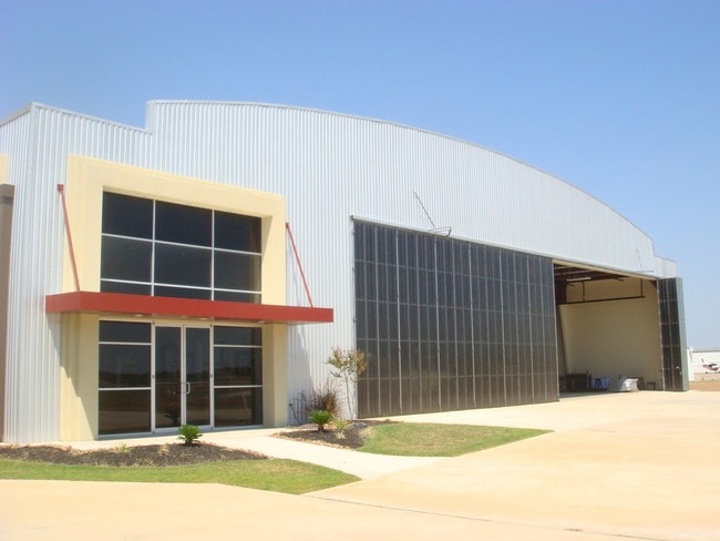
Property Record
9472 Airport Rd, Conroe, TX 77303
NEARBY LISTINGS FOR SALE OR LEASE
-
-
View all Conroe listings for lease on LoopNet.com
Property Detail
9472 Airport Rd
0498-00-00100
Singleton J W
Commercialnec
A0498 SINGLETON J W, TRACT 1, MONT CO AIRPORT/PARK, ACRES 249.256
X
Montgomery
48339C0385G
Texas
0
249.26 AC
2025
Outlying Montgomery Cnty
693901
Houston
38,742 SF
Houston-Pasadena-The Woodlands, TX
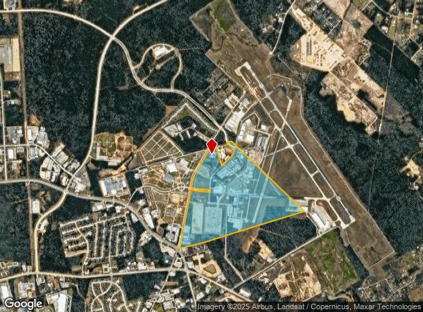
DEMOGRAPHICS near 9472 Airport Rd
1 Mile
3 Mile
5 Mile
2024 Total Population
709
26,250
78,704
2029 Population
860
31,877
96,437
Pop Growth 2024-2029
+ 21.30%
+ 21.44%
+ 22.53%
Average Age
38
35
36
2024 Total Households
207
7,752
26,792
HH Growth 2024-2029
+ 21.74%
+ 23.22%
+ 23.20%
Median Household Inc
$49,478
$61,921
$59,234
Avg Household Size
2.70
3.00
2.80
2024 Avg HH Vehicles
2.00
2.00
2.00
Median Home Value
$207,692
$197,261
$208,745
Median Year Built
2000
1999
1998
Nearby Places
Map Layers
Map Styles
 Street
 Aerial
- Restaurants
- Banks
- Shops
- Fitness
- Groceries
PUBLIC TRANSPORTATION
AIRPORT
George Bush Intcntl/Houston
DRIVE
WALK
Distance
George Bush Intcntl/Houston
47 min
36.9 mi
Freight Ports
Port of Houston
DRIVE
WALK
Distance
Port of Houston
70 min
52.6 mi
SALE & LEASE HISTORY
LISTING DATE
SALE/LEASE

Sep 15, 2020
For Lease
Sep 04, 2018
For Lease
Nov 02, 2016
For Lease
May 03, 2017
For Sale
Jul 08, 2021
For Lease
Nearby Properties
Address
Land Use
TOTAL SIZE
Lot Size
Zoning
Address
Land Use
TOTAL SIZE
Lot Size
Zoning
322,082 SF
36.56 AC
1
Address
Land Use
TOTAL SIZE
Lot Size
Zoning
776,164 SF
71.74 AC
Address
Land Use
TOTAL SIZE
Lot Size
Zoning
165,071 SF
16.01 AC
Address
Land Use
TOTAL SIZE
Lot Size
Zoning
398,842 SF
23.75 AC
1
Address
Land Use
TOTAL SIZE
Lot Size
Zoning
619,770 SF
81.76 AC
Address
Land Use
TOTAL SIZE
Lot Size
Zoning
191,700 SF
19.41 AC
1
Address
Land Use
TOTAL SIZE
Lot Size
Zoning
366,709 SF
27.72 AC
Address
Land Use
TOTAL SIZE
Lot Size
Zoning
399,360 SF
30 AC
Address
Land Use
TOTAL SIZE
Lot Size
Zoning
206,008 SF
107.61 AC
Address
Land Use
TOTAL SIZE
Lot Size
Zoning
141,100 SF
25.34 AC
Address
Land Use
TOTAL SIZE
Lot Size
Zoning
62,296 SF
20.62 AC
Address
Land Use
TOTAL SIZE
Lot Size
Zoning
214,039 SF
20 AC
Address
Land Use
TOTAL SIZE
Lot Size
Zoning
123,674 SF
21.67 AC
Address
Land Use
TOTAL SIZE
Lot Size
Zoning
376,980 SF
24.37 AC
1
Address
Land Use
TOTAL SIZE
Lot Size
Zoning
242,944 SF
179.58 AC
Address
Land Use
TOTAL SIZE
Lot Size
Zoning
235,219 SF
40.03 AC
Address
Land Use
TOTAL SIZE
Lot Size
Zoning
205,088 SF
79.14 AC
Address
Land Use
TOTAL SIZE
Lot Size
Zoning
93,668 SF
45.56 AC
Address
Land Use
TOTAL SIZE
Lot Size
Zoning
236,986 SF
19.54 AC
Address
Land Use
TOTAL SIZE
Lot Size
Zoning
210,383 SF
15.84 AC
Address
Land Use
TOTAL SIZE
Lot Size
Zoning
186,100 SF
29.68 AC
1
Address
Land Use
TOTAL SIZE
Lot Size
Zoning
192,624 SF
25.16 AC
Address
Land Use
TOTAL SIZE
Lot Size
Zoning
188,128 SF
30.49 AC
1
Address
Land Use
TOTAL SIZE
Lot Size
Zoning
82,078 SF
61.15 AC
1
Address
Land Use
TOTAL SIZE
Lot Size
Zoning
115,276 SF
15 AC
Address
Land Use
TOTAL SIZE
Lot Size
Zoning
41,700 SF
24.68 AC
Address
Land Use
TOTAL SIZE
Lot Size
Zoning
66,712 SF
17.28 AC
Address
Land Use
TOTAL SIZE
Lot Size
Zoning
163,014 SF
9.81 AC
1
Address
Land Use
TOTAL SIZE
Lot Size
Zoning
262,564 SF
51.89 AC
1
The World's #1 Commercial Real Estate Marketplace
Connect with us
© 2026 CoStar Group
The information above has been obtained from sources believed reliable. While we do not doubt its accuracy we have not verified it and make no guarantee, warranty or representation about it. It is your responsibility to independently confirm its accuracy and completeness. Any projections, opinions, assumptions, or estimates used are for example only and do not represent the current or future performance of the property. The value of this transaction to you depends on tax and other factors which should be evaluated by your tax, financial, and legal advisors. You and your advisors should conduct a careful, independent investigation of the property to determine to your satisfaction the suitability of the property for your needs.