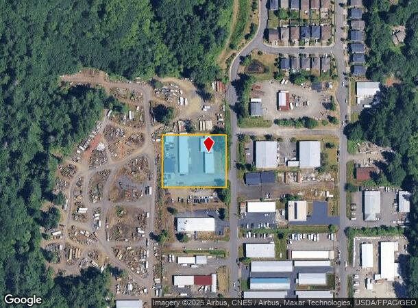
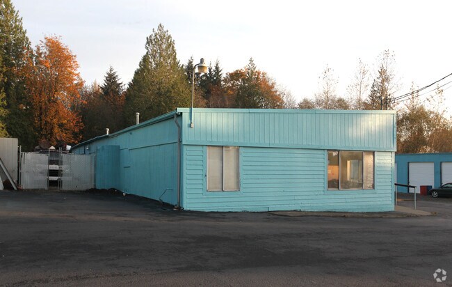
Property Record
5017 Joppa St Sw, Tumwater, WA 98512

NEARBY LISTINGS FOR SALE OR LEASE
Property Detail
5017 Joppa St Sw
Olympia-Tumwater, WA
Beehive Industrial Park
33720000500
SECTION 33 TOWNSHIP 18 RANGE 2W PLAT BEEHIVE INDUSTRIAL PARK LT 5 020063
Commercialnec
Thurston
X
Washington
53067C0168H
5
2024
1.17 AC
2024
Tumwater/S Olympia
010920
Olympia
10,488 SF
DEMOGRAPHICS near 5017 Joppa St Sw
1 Mile
3 Mile
5 Mile
2024 Total Population
5,085
44,561
101,049
2029 Population
5,445
47,202
106,820
Pop Growth 2024-2029
+ 7.08%
+ 5.93%
+ 5.71%
Average Age
44
41
41
2024 Total Households
2,270
19,221
42,648
HH Growth 2024-2029
+ 7.27%
+ 5.97%
+ 5.83%
Median Household Inc
$65,292
$69,476
$77,180
Avg Household Size
2.20
2.20
2.30
2024 Avg HH Vehicles
2.00
2.00
2.00
Median Home Value
$365,884
$412,965
$418,749
Median Year Built
1991
1987
1987
Nearby Places
Map Layers
Map Styles
 Street
 Aerial
- Restaurants
- Banks
- Shops
- Fitness
- Groceries
PUBLIC TRANSPORTATION
COMMUTER RAIL
Olympia-Lacey Amtrak Station (Amtrak Cascades - Amtrak, Coast Starlight - Amtrak)
DRIVE
WALK
Distance
Olympia-Lacey Amtrak Station (Amtrak Cascades - Amtrak, Coast Starlight - Amtrak)
20 min
9.4 mi
Freight Ports
Port of Tacoma
DRIVE
WALK
Distance
Port of Tacoma
47 min
35.0 mi
Nearby Properties
Address
Land Use
TOTAL SIZE
Lot Size
Zoning
Address
Land Use
TOTAL SIZE
Lot Size
Zoning
1,446,648 SF
8.29 AC
CAP
Address
Land Use
TOTAL SIZE
Lot Size
Zoning
830,626 SF
21.53 AC
CAP
Address
Land Use
TOTAL SIZE
Lot Size
Zoning
523,407 SF
86.49 AC
R-4-8
Address
Land Use
TOTAL SIZE
Lot Size
Zoning
485,918 SF
6.64 AC
CAP
Address
Land Use
TOTAL SIZE
Lot Size
Zoning
395,355 SF
35.74 AC
TC
Address
Land Use
TOTAL SIZE
Lot Size
Zoning
784,559 SF
13.09 AC
CAP
Address
Land Use
TOTAL SIZE
Lot Size
Zoning
288,270 SF
11.88 AC
CAP
Address
Land Use
TOTAL SIZE
Lot Size
Zoning
179,860 SF
1.28 AC
CAP
Address
Land Use
TOTAL SIZE
Lot Size
Zoning
353,503 SF
36.94 AC
MFM
Address
Land Use
TOTAL SIZE
Lot Size
Zoning
213,177 SF
1.28 AC
CAP
Address
Land Use
TOTAL SIZE
Lot Size
Zoning
184,887 SF
41 AC
SFM1
Address
Land Use
TOTAL SIZE
Lot Size
Zoning
602,509 SF
49.48 AC
HDC-4
Address
Land Use
TOTAL SIZE
Lot Size
Zoning
151,657 SF
2.62 AC
MS
Address
Land Use
TOTAL SIZE
Lot Size
Zoning
235,042 SF
17.16 AC
MFM
Address
Land Use
TOTAL SIZE
Lot Size
Zoning
226,221 SF
Address
Land Use
TOTAL SIZE
Lot Size
Zoning
243,845 SF
12.58 AC
RM-24
Address
Land Use
TOTAL SIZE
Lot Size
Zoning
273,091 SF
17.87 AC
PO/RM
Address
Land Use
TOTAL SIZE
Lot Size
Zoning
146,122 SF
Address
Land Use
TOTAL SIZE
Lot Size
Zoning
163,487 SF
34.49 AC
CS
Address
Land Use
TOTAL SIZE
Lot Size
Zoning
94,349 SF
6.02 AC
CAP
Address
Land Use
TOTAL SIZE
Lot Size
Zoning
217,366 SF
10.88 AC
RM-24
Address
Land Use
TOTAL SIZE
Lot Size
Zoning
102,698 SF
14.81 AC
LI
Address
Land Use
TOTAL SIZE
Lot Size
Zoning
197,571 SF
52.35 AC
R-4-8
Address
Land Use
TOTAL SIZE
Lot Size
Zoning
147,418 SF
11.74 AC
MFH
Address
Land Use
TOTAL SIZE
Lot Size
Zoning
241,689 SF
10.75 AC
RM-24
Address
Land Use
TOTAL SIZE
Lot Size
Zoning
175,938 SF
13 AC
MFM
Address
Land Use
TOTAL SIZE
Lot Size
Zoning
120,284 SF
118 AC
ARI2
Address
Land Use
TOTAL SIZE
Lot Size
Zoning
161,002 SF
8.66 AC
PO/RM
Address
Land Use
TOTAL SIZE
Lot Size
Zoning
155,386 SF
6.88 AC
CBC
Address
Land Use
TOTAL SIZE
Lot Size
Zoning
80,956 SF
20.97 AC
SFL
The World's #1 Commercial Real Estate Marketplace
Connect with us
© 2025 CoStar Group
The information above has been obtained from sources believed reliable. While we do not doubt its accuracy we have not verified it and make no guarantee, warranty or representation about it. It is your responsibility to independently confirm its accuracy and completeness. Any projections, opinions, assumptions, or estimates used are for example only and do not represent the current or future performance of the property. The value of this transaction to you depends on tax and other factors which should be evaluated by your tax, financial, and legal advisors. You and your advisors should conduct a careful, independent investigation of the property to determine to your satisfaction the suitability of the property for your needs.