Property Record
5017 Duncan Rd, Punta Gorda, FL 33982

Save to a Folder
{{folder.Name}}
{{folder.ListingIds.length}} Properties
{{folder.ListingIds.length}} Property
Create a New Folder
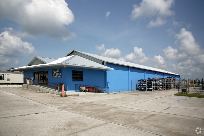
Property Detail
5017 Duncan Rd
402335126003
35-40-23 P-2 .6A BEG AT A POINT ON N LINE OF NE1/4 OF NW 1/4 ON NW R/W LINE OF HWAY 17 THEN SWERLY 300 FT THEN NW ERLY PERPEN DICULAR TO SAID HWAY TO N LINE OF N E1/4 OF NW1/4 THEN E TO BEG 311/696 506/843 900/80 E1112/741 1287/2029 3084/1271 ZZZ 2
Warehouse
Charlotte
CG
Florida
AE The base floodplain where base flood elevations are provided. AE Zones are now used on new format FIRMs instead of A1-A30 Zones.
21.19 AC
2024
Charlotte County
2025
Southwest Florida
010200
Punta Gorda, FL
8,750 SF
NEARBY LISTINGS FOR SALE OR LEASE
DEMOGRAPHICS near 5017 Duncan Rd
1 mile
3 mile
5 mile
2025 Total Population
1,684
8,733
39,569
2030 Population
1,839
9,593
43,687
Pop Growth 2025-2030
+ 9.20%
+ 9.85%
+ 10.41%
Average Age
50
50
51
2025 Total Households
791
3,974
18,059
HH Growth 2025-2030
+ 9.10%
+ 9.69%
+ 10.39%
Median Household Inc
$45,573
$59,627
$65,586
Avg Household Size
2.10
2.20
2.10
2025 Avg HH Vehicles
2.00
2.00
2.00
Median Home Value
$327,976
$338,125
$329,908
Median Year Built
1987
1991
1995
Nearby Places
Map Layers
Map Styles
 Street
 Aerial
Layers
 Traffic
 Biking
Places
Listings with unknown addresses are not visible on the map
- Restaurants
- Banks
- Shops
- Fitness
- Groceries
PUBLIC TRANSPORTATION
AIRPORT
Punta Gorda
Drive
Walk
Distance
Punta Gorda
8 min
4.6 mi
Freight Ports
Port Manatee
Drive
Walk
Distance
Port Manatee
85 min
72.8 mi
Nearby Properties
Address
Land Use
TOTAL SIZE
Lot Size
Zoning
Address
Land Use
TOTAL SIZE
Lot Size
Zoning
121,585 SF
696.03 AC
RE1
Address
Land Use
TOTAL SIZE
Lot Size
Zoning
249,777 SF
48 AC
RMF10
Address
Land Use
TOTAL SIZE
Lot Size
Zoning
254.31 AC
PD
Address
Land Use
TOTAL SIZE
Lot Size
Zoning
385,350 SF
374.81 AC
ECAP
Address
Land Use
TOTAL SIZE
Lot Size
Zoning
134,308 SF
16 AC
RSF3.5
Address
Land Use
TOTAL SIZE
Lot Size
Zoning
125.54 AC
PD
Address
Land Use
TOTAL SIZE
Lot Size
Zoning
116,186 SF
20.02 AC
RMF10
Address
Land Use
TOTAL SIZE
Lot Size
Zoning
60,000 SF
9.87 AC
ECAP
Address
Land Use
TOTAL SIZE
Lot Size
Zoning
66,461 SF
10.86 AC
CG
Address
Land Use
TOTAL SIZE
Lot Size
Zoning
103,870 SF
17.06 AC
CG
Address
Land Use
TOTAL SIZE
Lot Size
Zoning
1,556 SF
23.08 AC
CG
Address
Land Use
TOTAL SIZE
Lot Size
Zoning
7,964 SF
7.86 AC
ECAP
Address
Land Use
TOTAL SIZE
Lot Size
Zoning
60,000 SF
1.44 AC
ECAP
Address
Land Use
TOTAL SIZE
Lot Size
Zoning
60.56 AC
PD
Address
Land Use
TOTAL SIZE
Lot Size
Zoning
31,194 SF
7.93 AC
CG
Address
Land Use
TOTAL SIZE
Lot Size
Zoning
34,854 SF
655 AC
ES
Address
Land Use
TOTAL SIZE
Lot Size
Zoning
106.30 AC
PD
Address
Land Use
TOTAL SIZE
Lot Size
Zoning
37,150 SF
3.66 AC
ECAP
Address
Land Use
TOTAL SIZE
Lot Size
Zoning
28.40 AC
PD
Address
Land Use
TOTAL SIZE
Lot Size
Zoning
28.03 AC
PD
Address
Land Use
TOTAL SIZE
Lot Size
Zoning
15,085 SF
2.90 AC
CG
Address
Land Use
TOTAL SIZE
Lot Size
Zoning
2,400 SF
1.65 AC
IG
Address
Land Use
TOTAL SIZE
Lot Size
Zoning
9.31 AC
RMF10
Address
Land Use
TOTAL SIZE
Lot Size
Zoning
29,800 SF
4.09 AC
CG
Address
Land Use
TOTAL SIZE
Lot Size
Zoning
6,894 SF
4.63 AC
SP
Address
Land Use
TOTAL SIZE
Lot Size
Zoning
24,461 SF
4.97 AC
ECAP
Address
Land Use
TOTAL SIZE
Lot Size
Zoning
23,988 SF
1.85 AC
ECAP
Address
Land Use
TOTAL SIZE
Lot Size
Zoning
13,992 SF
4.16 AC
CG
Address
Land Use
TOTAL SIZE
Lot Size
Zoning
18,256 SF
5.20 AC
RE1
The World's #1 Commercial Real Estate Marketplace
Connect with us
© 2026 CoStar Group
The information above has been obtained from sources believed reliable. While we do not doubt its accuracy we have not verified it and make no guarantee, warranty or representation about it. It is your responsibility to independently confirm its accuracy and completeness. Any projections, opinions, assumptions, or estimates used are for example only and do not represent the current or future performance of the property. The value of this transaction to you depends on tax and other factors which should be evaluated by your tax, financial, and legal advisors. You and your advisors should conduct a careful, independent investigation of the property to determine to your satisfaction the suitability of the property for your needs.