Property Record
50180 Cesar Chavez St, Coachella, CA 92236
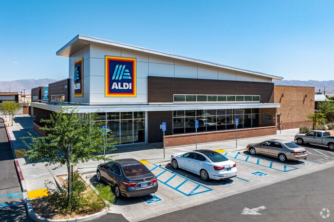

Property Detail
50180 Cesar Chavez St
Riverside-San Bernardino-Ontario, CA
ACRES 1.94000000 ACREAGEQUALCODE ML LOTTYPE P PARCEL 1 MAPPLATB 254 MAPPLATP 081 SUBDIVISIONNAME PM 37940
778-020-008
RIVERSIDE
Supermarket
California
2024
1.94 AC
2025
Coachella Valley
045707
Inland Empire (California)
21,016 SF
NEARBY LISTINGS FOR SALE OR LEASE
DEMOGRAPHICS near 50180 Cesar Chavez St
1 mile
3 mile
5 mile
2025 Total Population
17,233
60,246
125,886
2030 Population
17,563
62,200
130,666
Pop Growth 2025-2030
+ 1.91%
+ 3.24%
+ 3.80%
Average Age
34
35
37
2025 Total Households
4,101
15,594
36,321
HH Growth 2025-2030
+ 1.54%
+ 3.63%
+ 4.32%
Median Household Inc
$64,522
$69,810
$74,594
Avg Household Size
4.10
3.70
3.30
2025 Avg HH Vehicles
2.00
2.00
2.00
Median Home Value
$353,193
$414,215
$455,122
Median Year Built
1987
1998
1994
Nearby Places
Map Layers
Map Styles
 Street
 Aerial
Layers
 Traffic
 Biking
Places
Listings with unknown addresses are not visible on the map
- Restaurants
- Banks
- Shops
- Fitness
- Groceries
PUBLIC TRANSPORTATION
AIRPORT
Palm Springs International
Drive
Walk
Distance
Palm Springs International
34 min
26.0 mi
Freight Ports
Port of San Diego
Drive
Walk
Distance
Port of San Diego
179 min
150.2 mi
Nearby Properties
Address
Land Use
TOTAL SIZE
Lot Size
Zoning
Address
Land Use
TOTAL SIZE
Lot Size
Zoning
52,901 SF
6 AC
Address
Land Use
TOTAL SIZE
Lot Size
Zoning
133,694 SF
5.83 AC
Address
Land Use
TOTAL SIZE
Lot Size
Zoning
177,392 SF
25.40 AC
MH
Address
Land Use
TOTAL SIZE
Lot Size
Zoning
41,091 SF
4.65 AC
Address
Land Use
TOTAL SIZE
Lot Size
Zoning
105,122 SF
2.23 AC
Address
Land Use
TOTAL SIZE
Lot Size
Zoning
275,931 SF
37.69 AC
Address
Land Use
TOTAL SIZE
Lot Size
Zoning
100,110 SF
4.03 AC
Address
Land Use
TOTAL SIZE
Lot Size
Zoning
86,479 SF
6.46 AC
Address
Land Use
TOTAL SIZE
Lot Size
Zoning
44,511 SF
9.40 AC
CM
Address
Land Use
TOTAL SIZE
Lot Size
Zoning
34,312 SF
3.15 AC
Address
Land Use
TOTAL SIZE
Lot Size
Zoning
84,490 SF
4.20 AC
R3
Address
Land Use
TOTAL SIZE
Lot Size
Zoning
40,380 SF
17.55 AC
Address
Land Use
TOTAL SIZE
Lot Size
Zoning
30,000 SF
2.98 AC
Address
Land Use
TOTAL SIZE
Lot Size
Zoning
53,705 SF
5.10 AC
A1
Address
Land Use
TOTAL SIZE
Lot Size
Zoning
31,708 SF
5.07 AC
R3
Address
Land Use
TOTAL SIZE
Lot Size
Zoning
37,282 SF
9.92 AC
CG
Address
Land Use
TOTAL SIZE
Lot Size
Zoning
58,586 SF
6.03 AC
Address
Land Use
TOTAL SIZE
Lot Size
Zoning
13,888 SF
4.36 AC
R3
Address
Land Use
TOTAL SIZE
Lot Size
Zoning
74,437 SF
8.80 AC
R1
Address
Land Use
TOTAL SIZE
Lot Size
Zoning
42,247 SF
8.40 AC
Address
Land Use
TOTAL SIZE
Lot Size
Zoning
76.89 AC
A120
Address
Land Use
TOTAL SIZE
Lot Size
Zoning
140,069 SF
8.37 AC
M
Address
Land Use
TOTAL SIZE
Lot Size
Zoning
1,589 SF
65.71 AC
A110
Address
Land Use
TOTAL SIZE
Lot Size
Zoning
76,200 SF
11.19 AC
Address
Land Use
TOTAL SIZE
Lot Size
Zoning
19,059 SF
8.15 AC
Address
Land Use
TOTAL SIZE
Lot Size
Zoning
34,458 SF
4.27 AC
R3
Address
Land Use
TOTAL SIZE
Lot Size
Zoning
21,170 SF
7.27 AC
RM
Address
Land Use
TOTAL SIZE
Lot Size
Zoning
76,880 SF
8.30 AC
Address
Land Use
TOTAL SIZE
Lot Size
Zoning
25,370 SF
6.61 AC
A1050
Address
Land Use
TOTAL SIZE
Lot Size
Zoning
The World's #1 Commercial Real Estate Marketplace
Connect with us
© 2026 CoStar Group
The information above has been obtained from sources believed reliable. While we do not doubt its accuracy we have not verified it and make no guarantee, warranty or representation about it. It is your responsibility to independently confirm its accuracy and completeness. Any projections, opinions, assumptions, or estimates used are for example only and do not represent the current or future performance of the property. The value of this transaction to you depends on tax and other factors which should be evaluated by your tax, financial, and legal advisors. You and your advisors should conduct a careful, independent investigation of the property to determine to your satisfaction the suitability of the property for your needs.