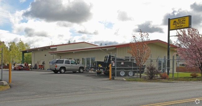
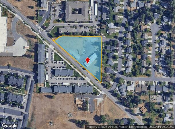
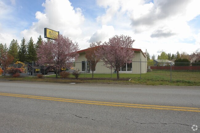
Property Record
5019 S Palouse Hwy, Spokane, WA 99223
NEARBY LISTINGS FOR SALE OR LEASE
Property Detail
5019 S Palouse Hwy
34032.9107
03 24 43 PTN OF N1/2 OF GOV L11 DAF; BEG 582.35 E & 127 S OF NW COR OF SD N1/2 OF GOV L11 & TRUE POB TH W345.81 T H ALG A TANGENT CURVE TO LEFT A RAD OF 100 THRU A C/A OF 48DE G 52MIN AN ARC DIST OF 85.29 TH ALG A TANGENT REVERSE CURVE T O RT WITH A
Storebuilding
Spokane
X
Washington
53063C0726D
11
2025
2.35 AC
2025
South Hill
004800
Spokane
6,075 SF
Spokane-Spokane Valley, WA
DEMOGRAPHICS near 5019 S Palouse Hwy
1 Mile
3 Mile
5 Mile
2024 Total Population
16,145
61,760
129,730
2029 Population
17,276
65,874
138,368
Pop Growth 2024-2029
+ 7.01%
+ 6.66%
+ 6.66%
Average Age
40
42
41
2024 Total Households
7,056
25,392
54,497
HH Growth 2024-2029
+ 7.16%
+ 6.85%
+ 7.01%
Median Household Inc
$73,278
$83,422
$65,384
Avg Household Size
2.30
2.40
2.20
2024 Avg HH Vehicles
2.00
2.00
2.00
Median Home Value
$410,327
$420,940
$390,652
Median Year Built
1994
1978
1973
Nearby Places
Map Layers
Map Styles
 Street
 Aerial
- Restaurants
- Banks
- Shops
- Fitness
- Groceries
PUBLIC TRANSPORTATION
COMMUTER RAIL
DRIVE
WALK
Distance
14 min
5.3 mi
AIRPORT
Spokane International
DRIVE
WALK
Distance
Spokane International
22 min
12.5 mi
Nearby Properties
Address
Land Use
TOTAL SIZE
Lot Size
Zoning
Address
Land Use
TOTAL SIZE
Lot Size
Zoning
226,702 SF
49.25 AC
RSF
Address
Land Use
TOTAL SIZE
Lot Size
Zoning
365,804 SF
16.13 AC
RSF
Address
Land Use
TOTAL SIZE
Lot Size
Zoning
270,262 SF
29.10 AC
Address
Land Use
TOTAL SIZE
Lot Size
Zoning
218,684 SF
13.29 AC
RMF
Address
Land Use
TOTAL SIZE
Lot Size
Zoning
124,234 SF
13.54 AC
RSF
Address
Land Use
TOTAL SIZE
Lot Size
Zoning
210,277 SF
19.18 AC
RMF
Address
Land Use
TOTAL SIZE
Lot Size
Zoning
289,573 SF
7.73 AC
RMF
Address
Land Use
TOTAL SIZE
Lot Size
Zoning
135,715 SF
4.73 AC
RMF
Address
Land Use
TOTAL SIZE
Lot Size
Zoning
119,933 SF
5.61 AC
Address
Land Use
TOTAL SIZE
Lot Size
Zoning
159,720 SF
6.84 AC
RMF
Address
Land Use
TOTAL SIZE
Lot Size
Zoning
78,990 SF
5.58 AC
RSF
Address
Land Use
TOTAL SIZE
Lot Size
Zoning
173,714 SF
9.98 AC
HDR
Address
Land Use
TOTAL SIZE
Lot Size
Zoning
142,500 SF
6.86 AC
RMF
Address
Land Use
TOTAL SIZE
Lot Size
Zoning
172,388 SF
13.59 AC
RSF
Address
Land Use
TOTAL SIZE
Lot Size
Zoning
59,826 SF
6.79 AC
RSF
Address
Land Use
TOTAL SIZE
Lot Size
Zoning
55,623 SF
4.46 AC
MU
Address
Land Use
TOTAL SIZE
Lot Size
Zoning
75,680 SF
3.93 AC
RSF
Address
Land Use
TOTAL SIZE
Lot Size
Zoning
107,442 SF
5.57 AC
MF-2
Address
Land Use
TOTAL SIZE
Lot Size
Zoning
144,382 SF
5.43 AC
CC2
Address
Land Use
TOTAL SIZE
Lot Size
Zoning
130,878 SF
5.57 AC
CC2
Address
Land Use
TOTAL SIZE
Lot Size
Zoning
105,728 SF
4.53 AC
RMF
Address
Land Use
TOTAL SIZE
Lot Size
Zoning
121,962 SF
3.80 AC
RMF
Address
Land Use
TOTAL SIZE
Lot Size
Zoning
108,609 SF
4.11 AC
MU
Address
Land Use
TOTAL SIZE
Lot Size
Zoning
50,179 SF
5.54 AC
RSF
Address
Land Use
TOTAL SIZE
Lot Size
Zoning
175,671 SF
10.89 AC
RSF
Address
Land Use
TOTAL SIZE
Lot Size
Zoning
117,668 SF
7.52 AC
CC2
Address
Land Use
TOTAL SIZE
Lot Size
Zoning
111,808 SF
5.65 AC
RMF
Address
Land Use
TOTAL SIZE
Lot Size
Zoning
102,441 SF
8.38 AC
Address
Land Use
TOTAL SIZE
Lot Size
Zoning
164,592 SF
12.01 AC
RMF
Address
Land Use
TOTAL SIZE
Lot Size
Zoning
265,644 SF
8.45 AC
RMF
The World's #1 Commercial Real Estate Marketplace
Connect with us
© 2025 CoStar Group
The information above has been obtained from sources believed reliable. While we do not doubt its accuracy we have not verified it and make no guarantee, warranty or representation about it. It is your responsibility to independently confirm its accuracy and completeness. Any projections, opinions, assumptions, or estimates used are for example only and do not represent the current or future performance of the property. The value of this transaction to you depends on tax and other factors which should be evaluated by your tax, financial, and legal advisors. You and your advisors should conduct a careful, independent investigation of the property to determine to your satisfaction the suitability of the property for your needs.