Property Record
502 Box Elder Rd W, Box Elder, SD 57719


Save to a Folder
{{folder.Name}}
{{folder.ListingIds.length}} Properties
{{folder.ListingIds.length}} Property
Create a New Folder
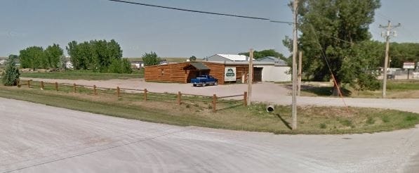
Property Detail
502 Box Elder Rd W
0000256
S24, T2N, R08E, BLACK HILLS MERIDIAN, LOT 2 OF TRACT B OF NE1/4SW1/4
Autorepair
Pennington
AE The base floodplain where base flood elevations are provided. AE Zones are now used on new format FIRMs instead of A1-A30 Zones.
South Dakota
2025
2
2025
3.06 AC
011800
Other Market Areas
3,880 SF
Rapid City, SD
NEARBY LISTINGS FOR SALE OR LEASE
-
-
View all Box Elder listings for sale on LoopNet.com
DEMOGRAPHICS near 502 Box Elder Rd W
1 mile
3 mile
5 mile
2025 Total Population
2,464
12,335
31,342
2030 Population
2,537
13,002
32,977
Pop Growth 2025-2030
+ 2.96%
+ 5.41%
+ 5.22%
Average Age
38
35
36
2025 Total Households
910
4,286
11,532
HH Growth 2025-2030
+ 2.53%
+ 5.88%
+ 5.53%
Median Household Inc
$78,268
$71,712
$79,451
Avg Household Size
2.60
2.70
2.60
2025 Avg HH Vehicles
3.00
2.00
2.00
Median Home Value
$246,101
$286,907
$283,059
Median Year Built
1987
2002
1999
Nearby Places
Map Layers
Map Styles
 Street
 Aerial
Layers
 Traffic
 Biking
Places
Listings with unknown addresses are not visible on the map
- Restaurants
- Banks
- Shops
- Fitness
- Groceries
PUBLIC TRANSPORTATION
AIRPORT
Rapid City Regional
Drive
Walk
Distance
Rapid City Regional
20 min
8.4 mi
SALE & LEASE HISTORY
LISTING DATE
SALE/LEASE

Sep 23, 2016
For Sale
Nov 21, 2016
For Lease
Feb 03, 2017
For Sale
Nearby Properties
Address
Land Use
TOTAL SIZE
Lot Size
Zoning
Address
Land Use
TOTAL SIZE
Lot Size
Zoning
19,781 SF
11.03 AC
Address
Land Use
TOTAL SIZE
Lot Size
Zoning
33,719 SF
8.15 AC
Address
Land Use
TOTAL SIZE
Lot Size
Zoning
2,632 SF
8.11 AC
Address
Land Use
TOTAL SIZE
Lot Size
Zoning
28,894 SF
2.17 AC
Address
Land Use
TOTAL SIZE
Lot Size
Zoning
29,196 SF
3.89 AC
Address
Land Use
TOTAL SIZE
Lot Size
Zoning
24,297 SF
5.15 AC
Address
Land Use
TOTAL SIZE
Lot Size
Zoning
39,374 SF
10 AC
Address
Land Use
TOTAL SIZE
Lot Size
Zoning
16,142 SF
1.92 AC
Address
Land Use
TOTAL SIZE
Lot Size
Zoning
19,376 SF
3 AC
Address
Land Use
TOTAL SIZE
Lot Size
Zoning
15,095 SF
11.39 AC
Address
Land Use
TOTAL SIZE
Lot Size
Zoning
15,555 SF
13.30 AC
Address
Land Use
TOTAL SIZE
Lot Size
Zoning
936 SF
3.49 AC
Address
Land Use
TOTAL SIZE
Lot Size
Zoning
14,519 SF
2.52 AC
Address
Land Use
TOTAL SIZE
Lot Size
Zoning
16,795 SF
3.60 AC
Address
Land Use
TOTAL SIZE
Lot Size
Zoning
58,800 SF
6.63 AC
Address
Land Use
TOTAL SIZE
Lot Size
Zoning
8,239 SF
20 AC
Address
Land Use
TOTAL SIZE
Lot Size
Zoning
48,842 SF
5.09 AC
Address
Land Use
TOTAL SIZE
Lot Size
Zoning
11,900 SF
10.85 AC
Address
Land Use
TOTAL SIZE
Lot Size
Zoning
12,561 SF
10.01 AC
Address
Land Use
TOTAL SIZE
Lot Size
Zoning
30,000 SF
7.19 AC
Address
Land Use
TOTAL SIZE
Lot Size
Zoning
12,092 SF
2.29 AC
Address
Land Use
TOTAL SIZE
Lot Size
Zoning
20,000 SF
6.83 AC
Address
Land Use
TOTAL SIZE
Lot Size
Zoning
41,250 SF
7.72 AC
Address
Land Use
TOTAL SIZE
Lot Size
Zoning
65,408 SF
14.81 AC
Address
Land Use
TOTAL SIZE
Lot Size
Zoning
9,839 SF
2.06 AC
Address
Land Use
TOTAL SIZE
Lot Size
Zoning
3,000 SF
10 AC
Address
Land Use
TOTAL SIZE
Lot Size
Zoning
10,824 SF
1.58 AC
Address
Land Use
TOTAL SIZE
Lot Size
Zoning
27,525 SF
5.83 AC
Address
Land Use
TOTAL SIZE
Lot Size
Zoning
40,200 SF
5.73 AC
Address
Land Use
TOTAL SIZE
Lot Size
Zoning
9,430 SF
4.27 AC
The World's #1 Commercial Real Estate Marketplace
Connect with us
© 2026 CoStar Group
The information above has been obtained from sources believed reliable. While we do not doubt its accuracy we have not verified it and make no guarantee, warranty or representation about it. It is your responsibility to independently confirm its accuracy and completeness. Any projections, opinions, assumptions, or estimates used are for example only and do not represent the current or future performance of the property. The value of this transaction to you depends on tax and other factors which should be evaluated by your tax, financial, and legal advisors. You and your advisors should conduct a careful, independent investigation of the property to determine to your satisfaction the suitability of the property for your needs.