Property Record
502 Cedar St, Cedar Hill, TX 75104

NEARBY LISTINGS FOR SALE OR LEASE
Property Detail
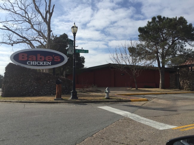
502 Cedar St
16000500000000000
Orig Town Cedar Hill
Restaurantbuilding
ORIG TOWN CEDAR HILL PUBLIC SQUARE ACS 0.9223 OT SHEET 1, SWC CEDAR @ MAIN CO-DC 0005000000000 21600050000
X
Dallas
48139C0030G
Texas
2024
0.92 AC
2025
C Hill/Dunc'vlle/Deso
016524
Dallas/Ft Worth
10,800 SF
Dallas-Fort Worth-Arlington, TX
DEMOGRAPHICS near 502 Cedar St
1 Mile
3 Mile
5 Mile
2024 Total Population
5,794
47,007
105,149
2029 Population
5,879
46,447
104,906
Pop Growth 2024-2029
+ 1.47%
(1.19%)
(0.23%)
Average Age
38
37
38
2024 Total Households
2,097
15,756
34,812
HH Growth 2024-2029
+ 1.34%
(1.34%)
(0.35%)
Median Household Inc
$64,674
$73,965
$82,436
Avg Household Size
2.70
2.90
3.00
2024 Avg HH Vehicles
2.00
2.00
2.00
Median Home Value
$223,905
$231,582
$249,512
Median Year Built
1990
1992
1992
Nearby Places
Map Layers
Map Styles
 Street
 Aerial
- Restaurants
- Banks
- Shops
- Fitness
- Groceries
PUBLIC TRANSPORTATION
AIRPORT
Dallas Love Field
DRIVE
WALK
Distance
Dallas Love Field
32 min
22.7 mi
Dallas-Fort Worth International
DRIVE
WALK
Distance
Dallas-Fort Worth International
36 min
26.7 mi
Freight Ports
Port of Shreveport
DRIVE
WALK
Distance
Port of Shreveport
222 min
207.1 mi
Nearby Properties
Address
Land Use
TOTAL SIZE
Lot Size
Zoning
Address
Land Use
TOTAL SIZE
Lot Size
Zoning
1,108,080 SF
66.41 AC
Address
Land Use
TOTAL SIZE
Lot Size
Zoning
446,164 SF
13.45 AC
Z137
Address
Land Use
TOTAL SIZE
Lot Size
Zoning
1,108,080 SF
32.88 AC
Z109
Address
Land Use
TOTAL SIZE
Lot Size
Zoning
494,366 SF
43.30 AC
Z137
Address
Land Use
TOTAL SIZE
Lot Size
Zoning
374,277 SF
17.41 AC
Z137
Address
Land Use
TOTAL SIZE
Lot Size
Zoning
217,510 SF
67.57 AC
Z268
Address
Land Use
TOTAL SIZE
Lot Size
Zoning
248,819 SF
92.33 AC
AA1
Address
Land Use
TOTAL SIZE
Lot Size
Zoning
219,128 SF
11.62 AC
Z160
Address
Land Use
TOTAL SIZE
Lot Size
Zoning
219,152 SF
14.31 AC
Z160
Address
Land Use
TOTAL SIZE
Lot Size
Zoning
420,000 SF
35.38 AC
Z109
Address
Land Use
TOTAL SIZE
Lot Size
Zoning
188,600 SF
13.52 AC
Z160
Address
Land Use
TOTAL SIZE
Lot Size
Zoning
115,000 SF
15.89 AC
Z137
Address
Land Use
TOTAL SIZE
Lot Size
Zoning
223,899 SF
10 AC
Z160
Address
Land Use
TOTAL SIZE
Lot Size
Zoning
168,476 SF
8.15 AC
Z137
Address
Land Use
TOTAL SIZE
Lot Size
Zoning
299,986 SF
26.32 AC
Z137
Address
Land Use
TOTAL SIZE
Lot Size
Zoning
176,010 SF
16.72 AC
Z137
Address
Land Use
TOTAL SIZE
Lot Size
Zoning
347,760 SF
21.61 AC
Z109
Address
Land Use
TOTAL SIZE
Lot Size
Zoning
174,708 SF
9.78 AC
Z360
Address
Land Use
TOTAL SIZE
Lot Size
Zoning
308,880 SF
19.03 AC
Z109
Address
Land Use
TOTAL SIZE
Lot Size
Zoning
118,617 SF
23.20 AC
Z360
Address
Land Use
TOTAL SIZE
Lot Size
Zoning
321,600 SF
19.58 AC
Z109
Address
Land Use
TOTAL SIZE
Lot Size
Zoning
224,000 SF
15.42 AC
Address
Land Use
TOTAL SIZE
Lot Size
Zoning
148,971 SF
15.11 AC
Z137
Address
Land Use
TOTAL SIZE
Lot Size
Zoning
238,680 SF
5.12 AC
Z109
Address
Land Use
TOTAL SIZE
Lot Size
Zoning
152,144 SF
0.01 AC
AA1
Address
Land Use
TOTAL SIZE
Lot Size
Zoning
135,000 SF
23.91 AC
Z360
Address
Land Use
TOTAL SIZE
Lot Size
Zoning
156,000 SF
11.31 AC
Z14
Address
Land Use
TOTAL SIZE
Lot Size
Zoning
30,926 SF
109.20 AC
AA1
Address
Land Use
TOTAL SIZE
Lot Size
Zoning
164,480 SF
13.21 AC
Z111
Address
Land Use
TOTAL SIZE
Lot Size
Zoning
154,000 SF
14.49 AC
Z111
The World's #1 Commercial Real Estate Marketplace
Connect with us
© 2025 CoStar Group
The information above has been obtained from sources believed reliable. While we do not doubt its accuracy we have not verified it and make no guarantee, warranty or representation about it. It is your responsibility to independently confirm its accuracy and completeness. Any projections, opinions, assumptions, or estimates used are for example only and do not represent the current or future performance of the property. The value of this transaction to you depends on tax and other factors which should be evaluated by your tax, financial, and legal advisors. You and your advisors should conduct a careful, independent investigation of the property to determine to your satisfaction the suitability of the property for your needs.