Property Record
502 E Main St, Florence, CO 81226
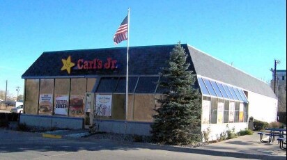

Property Detail
502 E Main St
000061006300
A TR OF LD IN THE N2N2 OF SEC 21 & THE S2S2 OF SEC 16-19-69 DESC AS FOLLS: BEG AT THE INTSEC OF THE S LN OF E MAIN ST WITH THE E LN OF S ROBINSON AVE; TH S77-30-00E ALG THE S LN OF E MAIN ST A DIST OF 149.0 FT; TH S12-30-00W A DIST OF 130.0 FT; TH S7
Miscellaneous
Fremont
AH Areas with a 1% annual chance of shallow flooding, usually in the form of a pond, withan average depth ranging from 1 to 3 feet. These areas have a 26% chance of flooding over the life of a 30-year mortgage.
Colorado
2025
0.94 AC
2025
Colorado Southwest Area
978200
Other Market Areas
3,978 SF
Cañon City, CO
NEARBY LISTINGS FOR SALE OR LEASE
DEMOGRAPHICS near 502 E Main St
1 mile
3 mile
5 mile
2025 Total Population
3,091
6,012
7,351
2030 Population
3,097
6,027
7,355
Pop Growth 2025-2030
+ 0.19%
+ 0.25%
+ 0.05%
Average Age
44
44
45
2025 Total Households
1,336
2,513
3,044
HH Growth 2025-2030
+ 0.15%
+ 0.16%
0.00%
Median Household Inc
$58,711
$59,450
$60,165
Avg Household Size
2.30
2.30
2.40
2025 Avg HH Vehicles
2.00
2.00
2.00
Median Home Value
$232,345
$240,852
$246,264
Median Year Built
1969
1975
1976
Nearby Places
Map Layers
Map Styles
 Street
 Aerial
Transit
 Traffic
 Biking
Places
Listings with unknown addresses are not visible on the map
- Restaurants
- Banks
- Shops
- Fitness
- Groceries
PUBLIC TRANSPORTATION
AIRPORT
City of Colorado Springs Municipal
Drive
Walk
Distance
City of Colorado Springs Municipal
69 min
45.9 mi
Nearby Properties
Address
Land Use
TOTAL SIZE
Lot Size
Zoning
Address
Land Use
TOTAL SIZE
Lot Size
Zoning
114,358 SF
2,944.07 AC
Address
Land Use
TOTAL SIZE
Lot Size
Zoning
16,368 SF
7.54 AC
Address
Land Use
TOTAL SIZE
Lot Size
Zoning
34,100 SF
2.95 AC
Address
Land Use
TOTAL SIZE
Lot Size
Zoning
26,712 SF
7.78 AC
Address
Land Use
TOTAL SIZE
Lot Size
Zoning
17,600 SF
10.94 AC
Address
Land Use
TOTAL SIZE
Lot Size
Zoning
13,367 SF
2.34 AC
Address
Land Use
TOTAL SIZE
Lot Size
Zoning
130,044 SF
102.77 AC
Address
Land Use
TOTAL SIZE
Lot Size
Zoning
3,184 SF
3.80 AC
Address
Land Use
TOTAL SIZE
Lot Size
Zoning
6,300 SF
374.29 AC
Address
Land Use
TOTAL SIZE
Lot Size
Zoning
9,042 SF
1.36 AC
Address
Land Use
TOTAL SIZE
Lot Size
Zoning
22,000 SF
1.32 AC
Address
Land Use
TOTAL SIZE
Lot Size
Zoning
9,450 SF
0.68 AC
Address
Land Use
TOTAL SIZE
Lot Size
Zoning
9,409 SF
0.85 AC
Address
Land Use
TOTAL SIZE
Lot Size
Zoning
157.85 AC
Address
Land Use
TOTAL SIZE
Lot Size
Zoning
13,824 SF
8.64 AC
Address
Land Use
TOTAL SIZE
Lot Size
Zoning
33,456 SF
2.64 AC
Address
Land Use
TOTAL SIZE
Lot Size
Zoning
7,957 SF
0.84 AC
Address
Land Use
TOTAL SIZE
Lot Size
Zoning
95,364 SF
3.14 AC
Address
Land Use
TOTAL SIZE
Lot Size
Zoning
19,320 SF
0.52 AC
Address
Land Use
TOTAL SIZE
Lot Size
Zoning
4,312 SF
1 AC
Address
Land Use
TOTAL SIZE
Lot Size
Zoning
4,800 SF
0.79 AC
Address
Land Use
TOTAL SIZE
Lot Size
Zoning
11,000 SF
0.13 AC
Address
Land Use
TOTAL SIZE
Lot Size
Zoning
9,796 SF
0.24 AC
Address
Land Use
TOTAL SIZE
Lot Size
Zoning
928 SF
9.21 AC
Address
Land Use
TOTAL SIZE
Lot Size
Zoning
16,672 SF
1.64 AC
Address
Land Use
TOTAL SIZE
Lot Size
Zoning
63.43 AC
Address
Land Use
TOTAL SIZE
Lot Size
Zoning
7,200 SF
2.81 AC
Address
Land Use
TOTAL SIZE
Lot Size
Zoning
4,640 SF
0.16 AC
Address
Land Use
TOTAL SIZE
Lot Size
Zoning
10,044 SF
0.14 AC
The World's #1 Commercial Real Estate Marketplace
Connect with us
© 2026 CoStar Group
The information above has been obtained from sources believed reliable. While we do not doubt its accuracy we have not verified it and make no guarantee, warranty or representation about it. It is your responsibility to independently confirm its accuracy and completeness. Any projections, opinions, assumptions, or estimates used are for example only and do not represent the current or future performance of the property. The value of this transaction to you depends on tax and other factors which should be evaluated by your tax, financial, and legal advisors. You and your advisors should conduct a careful, independent investigation of the property to determine to your satisfaction the suitability of the property for your needs.