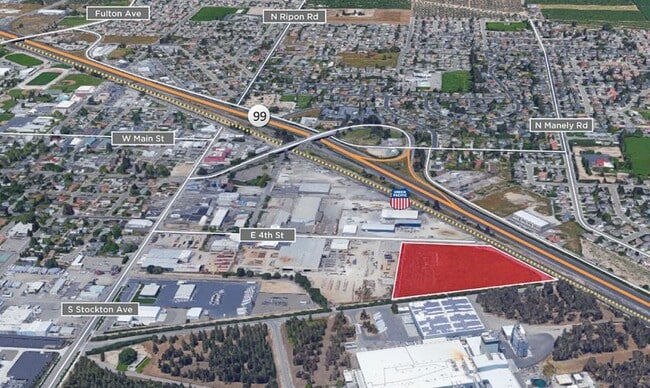
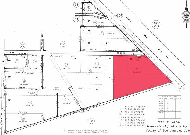
Property Record
502 Fourth St, Ripon, CA 95366

Property Detail
502 Fourth St
Stockton-Lodi, CA
08-FM PT 259-360-04/PT TO 31/32 07202041/07202042
259-360-33
SAN JOAQUIN
Publicstorage
California
B and X Area of moderate flood hazard, usually the area between the limits of the 100-year and 500-year floods.
7.82 AC
2025
Tracy/Manteca
2025
Stockton/Modesto
005001
NEARBY LISTINGS FOR SALE OR LEASE
DEMOGRAPHICS near 502 Fourth St
1 mile
3 mile
5 mile
2024 Total Population
6,109
29,235
45,738
2029 Population
6,322
29,812
46,672
Pop Growth 2024-2029
+ 3.49%
+ 1.97%
+ 2.04%
Average Age
41
38
38
2024 Total Households
2,237
9,437
14,854
HH Growth 2024-2029
+ 3.67%
+ 2.19%
+ 2.11%
Median Household Inc
$120,664
$106,656
$105,097
Avg Household Size
2.70
3.00
3.00
2024 Avg HH Vehicles
2.00
2.00
2.00
Median Home Value
$757,490
$627,812
$620,980
Median Year Built
1980
1993
1991
Nearby Places
Map Layers
Map Styles
 Street
 Aerial
Transit
 Traffic
 Biking
Places
Listings with unknown addresses are not visible on the map
- Restaurants
- Banks
- Shops
- Fitness
- Groceries
PUBLIC TRANSPORTATION
AIRPORT
Stockton Metro
Drive
Walk
Distance
Stockton Metro
23 min
16.0 mi
Freight Ports
Port of Stockton
Drive
Walk
Distance
Port of Stockton
32 min
24.5 mi
SALE & LEASE HISTORY
LISTING DATE
SALE/LEASE

Sep 16, 2020
For Sale
Nearby Properties
Address
Land Use
TOTAL SIZE
Lot Size
Zoning
Address
Land Use
TOTAL SIZE
Lot Size
Zoning
541,375 SF
37.18 AC
Address
Land Use
TOTAL SIZE
Lot Size
Zoning
25,000 SF
131.14 AC
Address
Land Use
TOTAL SIZE
Lot Size
Zoning
6,160 SF
46.47 AC
Address
Land Use
TOTAL SIZE
Lot Size
Zoning
7,812 SF
6.13 AC
CC
Address
Land Use
TOTAL SIZE
Lot Size
Zoning
85,040 SF
4.46 AC
Address
Land Use
TOTAL SIZE
Lot Size
Zoning
7,590 SF
3.51 AC
Address
Land Use
TOTAL SIZE
Lot Size
Zoning
4.36 AC
Address
Land Use
TOTAL SIZE
Lot Size
Zoning
139,638 SF
39.25 AC
Address
Land Use
TOTAL SIZE
Lot Size
Zoning
1,052 SF
360.20 AC
A240
Address
Land Use
TOTAL SIZE
Lot Size
Zoning
6,450 SF
17.97 AC
Address
Land Use
TOTAL SIZE
Lot Size
Zoning
87,000 SF
5.08 AC
COUPD
Address
Land Use
TOTAL SIZE
Lot Size
Zoning
24,995 SF
9.81 AC
MX
Address
Land Use
TOTAL SIZE
Lot Size
Zoning
75,945 SF
30.87 AC
Address
Land Use
TOTAL SIZE
Lot Size
Zoning
15,325 SF
16.91 AC
Address
Land Use
TOTAL SIZE
Lot Size
Zoning
9,238 SF
8.68 AC
Address
Land Use
TOTAL SIZE
Lot Size
Zoning
2.44 AC
R3
Address
Land Use
TOTAL SIZE
Lot Size
Zoning
49,883 SF
23.70 AC
Address
Land Use
TOTAL SIZE
Lot Size
Zoning
9,135 SF
2.06 AC
Address
Land Use
TOTAL SIZE
Lot Size
Zoning
35,414 SF
4 AC
Address
Land Use
TOTAL SIZE
Lot Size
Zoning
2.18 AC
Address
Land Use
TOTAL SIZE
Lot Size
Zoning
127,951 SF
21.11 AC
Address
Land Use
TOTAL SIZE
Lot Size
Zoning
49,726 SF
8.09 AC
Address
Land Use
TOTAL SIZE
Lot Size
Zoning
9,900 SF
6 AC
Address
Land Use
TOTAL SIZE
Lot Size
Zoning
39,972 SF
1.38 AC
COUC2
Address
Land Use
TOTAL SIZE
Lot Size
Zoning
1.56 AC
Address
Land Use
TOTAL SIZE
Lot Size
Zoning
21,782 SF
4.56 AC
Address
Land Use
TOTAL SIZE
Lot Size
Zoning
1,768 SF
184.34 AC
Address
Land Use
TOTAL SIZE
Lot Size
Zoning
7.24 AC
Address
Land Use
TOTAL SIZE
Lot Size
Zoning
51,742 SF
4.82 AC
The World's #1 Commercial Real Estate Marketplace
Connect with us
© 2026 CoStar Group
The information above has been obtained from sources believed reliable. While we do not doubt its accuracy we have not verified it and make no guarantee, warranty or representation about it. It is your responsibility to independently confirm its accuracy and completeness. Any projections, opinions, assumptions, or estimates used are for example only and do not represent the current or future performance of the property. The value of this transaction to you depends on tax and other factors which should be evaluated by your tax, financial, and legal advisors. You and your advisors should conduct a careful, independent investigation of the property to determine to your satisfaction the suitability of the property for your needs.