Property Record
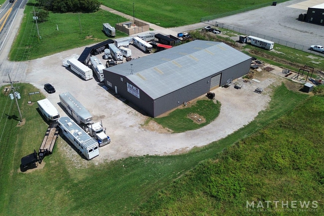
502 Highway 377, Pilot Point, TX 76258
Property Detail
502 Highway 377
253199
G-0459 GASS PETER A-G0459, ACRES 1.479
Commercialnec
GRAYSON
B and X Area of moderate flood hazard, usually the area between the limits of the 100-year and 500-year floods.
Texas
2024
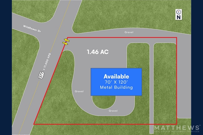
1.48 AC
2025
Outlying Denton County
020129
Other Market Areas
8,400 SF
Sherman-Denison, TX
NEARBY LISTINGS FOR SALE OR LEASE
DEMOGRAPHICS near 502 Highway 377
1 mile
3 mile
5 mile
2025 Total Population
1,062
7,009
9,452
2030 Population
1,216
8,067
10,738
Pop Growth 2025-2030
+ 14.50%
+ 15.09%
+ 13.61%
Average Age
40
40
40
2025 Total Households
370
2,434
3,345
HH Growth 2025-2030
+ 14.59%
+ 15.20%
+ 13.60%
Median Household Inc
$105,392
$103,867
$101,113
Avg Household Size
2.80
2.80
2.80
2025 Avg HH Vehicles
3.00
3.00
3.00
Median Home Value
$395,312
$401,493
$388,692
Median Year Built
2002
2002
2000
Nearby Places
Map Layers
Map Styles
 Street
 Aerial
Transit
 Traffic
 Biking
Places
Listings with unknown addresses are not visible on the map
- Restaurants
- Banks
- Shops
- Fitness
- Groceries
Nearby Properties
Address
Land Use
TOTAL SIZE
Lot Size
Zoning
Address
Land Use
TOTAL SIZE
Lot Size
Zoning
83,087 SF
23.24 AC
Address
Land Use
TOTAL SIZE
Lot Size
Zoning
118,721 SF
4.68 AC
Address
Land Use
TOTAL SIZE
Lot Size
Zoning
107,421 SF
15.99 AC
Address
Land Use
TOTAL SIZE
Lot Size
Zoning
312.59 AC
Address
Land Use
TOTAL SIZE
Lot Size
Zoning
210,260 SF
17.39 AC
Address
Land Use
TOTAL SIZE
Lot Size
Zoning
17.59 AC
Address
Land Use
TOTAL SIZE
Lot Size
Zoning
53,500 SF
3.30 AC
Address
Land Use
TOTAL SIZE
Lot Size
Zoning
42,263 SF
4.95 AC
Address
Land Use
TOTAL SIZE
Lot Size
Zoning
19,558 SF
2.53 AC
Address
Land Use
TOTAL SIZE
Lot Size
Zoning
51,500 SF
10 AC
Address
Land Use
TOTAL SIZE
Lot Size
Zoning
18,629 SF
1.61 AC
Address
Land Use
TOTAL SIZE
Lot Size
Zoning
8,640 SF
16.40 AC
Address
Land Use
TOTAL SIZE
Lot Size
Zoning
Address
Land Use
TOTAL SIZE
Lot Size
Zoning
Address
Land Use
TOTAL SIZE
Lot Size
Zoning
1,200 SF
15 AC
Address
Land Use
TOTAL SIZE
Lot Size
Zoning
Address
Land Use
TOTAL SIZE
Lot Size
Zoning
41,862 SF
3.25 AC
Address
Land Use
TOTAL SIZE
Lot Size
Zoning
10,400 SF
0.46 AC
Address
Land Use
TOTAL SIZE
Lot Size
Zoning
10,995 SF
0.79 AC
Address
Land Use
TOTAL SIZE
Lot Size
Zoning
24,460 SF
0.23 AC
Address
Land Use
TOTAL SIZE
Lot Size
Zoning
20,725 SF
1.86 AC
Address
Land Use
TOTAL SIZE
Lot Size
Zoning
5,735 SF
0.90 AC
Address
Land Use
TOTAL SIZE
Lot Size
Zoning
9,400 SF
0.98 AC
Address
Land Use
TOTAL SIZE
Lot Size
Zoning
484 SF
33.49 AC
Address
Land Use
TOTAL SIZE
Lot Size
Zoning
45,047 SF
4.41 AC
Address
Land Use
TOTAL SIZE
Lot Size
Zoning
23,276 SF
0.93 AC
12A
Address
Land Use
TOTAL SIZE
Lot Size
Zoning
Address
Land Use
TOTAL SIZE
Lot Size
Zoning
23,808 SF
1.88 AC
Address
Land Use
TOTAL SIZE
Lot Size
Zoning
15,854 SF
1.54 AC
Address
Land Use
TOTAL SIZE
Lot Size
Zoning
19,614 SF
15.60 AC
The World's #1 Commercial Real Estate Marketplace
Connect with us
© 2026 CoStar Group
The information above has been obtained from sources believed reliable. While we do not doubt its accuracy we have not verified it and make no guarantee, warranty or representation about it. It is your responsibility to independently confirm its accuracy and completeness. Any projections, opinions, assumptions, or estimates used are for example only and do not represent the current or future performance of the property. The value of this transaction to you depends on tax and other factors which should be evaluated by your tax, financial, and legal advisors. You and your advisors should conduct a careful, independent investigation of the property to determine to your satisfaction the suitability of the property for your needs.