Property Record
502 Main St, Gorham, ME 04038
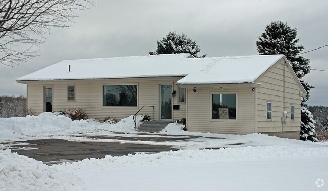
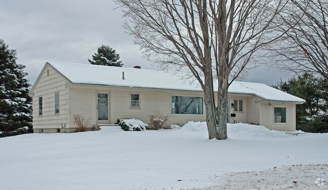
Property Detail
502 Main St
Officebuilding
Cumberland
CO
Maine
B and X Area of moderate flood hazard, usually the area between the limits of the 100-year and 500-year floods.
1.70 AC
2025
SW Cumberland County
2025
Portland/South Portland
004001
Portland-South Portland, ME
3,231 SF
GRHM-000031-000001
NEARBY LISTINGS FOR SALE OR LEASE
DEMOGRAPHICS near 502 Main St
1 mile
3 mile
5 mile
2024 Total Population
1,318
28,883
49,059
2029 Population
1,361
30,295
50,804
Pop Growth 2024-2029
+ 3.26%
+ 4.89%
+ 3.56%
Average Age
43
39
40
2024 Total Households
512
11,135
19,147
HH Growth 2024-2029
+ 3.32%
+ 4.94%
+ 3.62%
Median Household Inc
$121,064
$108,377
$106,559
Avg Household Size
2.40
2.40
2.40
2024 Avg HH Vehicles
2.00
2.00
2.00
Median Home Value
$480,239
$458,769
$445,066
Median Year Built
1991
1985
1980
Nearby Places
Map Layers
Map Styles
 Street
 Aerial
Transit
 Traffic
 Biking
Places
Listings with unknown addresses are not visible on the map
- Restaurants
- Banks
- Shops
- Fitness
- Groceries
PUBLIC TRANSPORTATION
COMMUTER RAIL
Drive
Walk
Distance
13 min
7.5 mi
AIRPORT
Portland International Jetport
Drive
Walk
Distance
Portland International Jetport
15 min
7.0 mi
Freight Ports
Portland, ME
Drive
Walk
Distance
Portland, ME
18 min
9.9 mi
Nearby Properties
Address
Land Use
TOTAL SIZE
Lot Size
Zoning
Address
Land Use
TOTAL SIZE
Lot Size
Zoning
84,636 SF
31.70 AC
22
Address
Land Use
TOTAL SIZE
Lot Size
Zoning
10.08 AC
Address
Land Use
TOTAL SIZE
Lot Size
Zoning
53.27 AC
22
Address
Land Use
TOTAL SIZE
Lot Size
Zoning
13.20 AC
I
Address
Land Use
TOTAL SIZE
Lot Size
Zoning
19.46 AC
UR
Address
Land Use
TOTAL SIZE
Lot Size
Zoning
139,588 SF
0.85 AC
16
Address
Land Use
TOTAL SIZE
Lot Size
Zoning
93,041 SF
5.53 AC
UR
Address
Land Use
TOTAL SIZE
Lot Size
Zoning
12.15 AC
11
Address
Land Use
TOTAL SIZE
Lot Size
Zoning
148,964 SF
35.12 AC
UR
Address
Land Use
TOTAL SIZE
Lot Size
Zoning
82,514 SF
59.10 AC
SR
Address
Land Use
TOTAL SIZE
Lot Size
Zoning
2,014 SF
189.60 AC
DZ
Address
Land Use
TOTAL SIZE
Lot Size
Zoning
7,860 SF
3.07 AC
UC
Address
Land Use
TOTAL SIZE
Lot Size
Zoning
79.65 AC
UR
Address
Land Use
TOTAL SIZE
Lot Size
Zoning
3.44 AC
27
Address
Land Use
TOTAL SIZE
Lot Size
Zoning
83,135 SF
7.23 AC
11
Address
Land Use
TOTAL SIZE
Lot Size
Zoning
25.14 AC
I
Address
Land Use
TOTAL SIZE
Lot Size
Zoning
60,869 SF
17.96 AC
UR
Address
Land Use
TOTAL SIZE
Lot Size
Zoning
97,200 SF
12.50 AC
12
Address
Land Use
TOTAL SIZE
Lot Size
Zoning
74,261 SF
13.03 AC
ND
Address
Land Use
TOTAL SIZE
Lot Size
Zoning
11.27 AC
11
Address
Land Use
TOTAL SIZE
Lot Size
Zoning
9.12 AC
11
Address
Land Use
TOTAL SIZE
Lot Size
Zoning
86,000 SF
7.17 AC
22
Address
Land Use
TOTAL SIZE
Lot Size
Zoning
124,365 SF
14.72 AC
22
Address
Land Use
TOTAL SIZE
Lot Size
Zoning
3,094 SF
69.40 AC
12
Address
Land Use
TOTAL SIZE
Lot Size
Zoning
57,820 SF
8.16 AC
21
Address
Land Use
TOTAL SIZE
Lot Size
Zoning
46,764 SF
4.64 AC
UC
Address
Land Use
TOTAL SIZE
Lot Size
Zoning
Address
Land Use
TOTAL SIZE
Lot Size
Zoning
13.07 AC
11
Address
Land Use
TOTAL SIZE
Lot Size
Zoning
7.20 AC
11
Address
Land Use
TOTAL SIZE
Lot Size
Zoning
171,000 SF
1.47 AC
16
The World's #1 Commercial Real Estate Marketplace
Connect with us
© 2026 CoStar Group
The information above has been obtained from sources believed reliable. While we do not doubt its accuracy we have not verified it and make no guarantee, warranty or representation about it. It is your responsibility to independently confirm its accuracy and completeness. Any projections, opinions, assumptions, or estimates used are for example only and do not represent the current or future performance of the property. The value of this transaction to you depends on tax and other factors which should be evaluated by your tax, financial, and legal advisors. You and your advisors should conduct a careful, independent investigation of the property to determine to your satisfaction the suitability of the property for your needs.