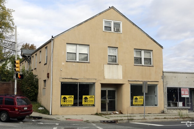
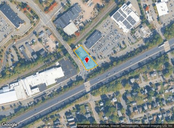
Property Record
502 Myrtle Ave, Boonton, NJ 07005
NEARBY LISTINGS FOR SALE OR LEASE
Property Detail
502 Myrtle Ave
Newark, NJ-PA
ADDITIONAL LOTS: 506 MYRTLE AVE
01-00069-0000-00075-04
Morris
Retailwithmorethanonenonretailuse
New Jersey
2024
75.4
2025
0.62 AC
041000
Parsippany
11,827 SF
Northern New Jersey
DEMOGRAPHICS near 502 Myrtle Ave
1 Mile
3 Mile
5 Mile
2024 Total Population
9,698
53,404
104,710
2029 Population
9,688
53,446
104,812
Pop Growth 2024-2029
(0.10%)
+ 0.08%
+ 0.10%
Average Age
42
42
43
2024 Total Households
3,778
20,304
38,663
HH Growth 2024-2029
+ 0.11%
+ 0.17%
+ 0.18%
Median Household Inc
$95,370
$110,471
$118,695
Avg Household Size
2.50
2.60
2.60
2024 Avg HH Vehicles
2.00
2.00
2.00
Median Home Value
$477,162
$583,648
$549,072
Median Year Built
1962
1968
1968
Nearby Places
Map Layers
Map Styles
 Street
 Aerial
- Restaurants
- Banks
- Shops
- Fitness
- Groceries
PUBLIC TRANSPORTATION
COMMUTER RAIL
Boonton (Montclair-Boonton Line - NJ Transit Commuter Rail (NJ Transit))
DRIVE
WALK
Distance
Boonton (Montclair-Boonton Line - NJ Transit Commuter Rail (NJ Transit))
1 min
12 min
0.6 mi
Mountain Lakes (Montclair-Boonton Line - NJ Transit Commuter Rail (NJ Transit))
DRIVE
WALK
Distance
Mountain Lakes (Montclair-Boonton Line - NJ Transit Commuter Rail (NJ Transit))
8 min
2.6 mi
AIRPORT
Newark Liberty International
DRIVE
WALK
Distance
Newark Liberty International
29 min
28.3 mi
LaGuardia
DRIVE
WALK
Distance
LaGuardia
50 min
43.3 mi
Freight Ports
Maher Terminal
DRIVE
WALK
Distance
Maher Terminal
1 min
19.7 mi
SALE & LEASE HISTORY
LISTING DATE
SALE/LEASE

Sep 24, 2016
For Sale
Nov 15, 2016
For Sale
Nov 09, 2017
For Sale
May 22, 2018
For Lease
Nearby Properties
Address
Land Use
TOTAL SIZE
Lot Size
Zoning
Address
Land Use
TOTAL SIZE
Lot Size
Zoning
98,228 SF
16.66 AC
I-1
Address
Land Use
TOTAL SIZE
Lot Size
Zoning
3.86 AC
O-3
Address
Land Use
TOTAL SIZE
Lot Size
Zoning
32.61 AC
R-5
Address
Land Use
TOTAL SIZE
Lot Size
Zoning
16.01 AC
R-C
Address
Land Use
TOTAL SIZE
Lot Size
Zoning
1,440 SF
38.80 AC
I-2
Address
Land Use
TOTAL SIZE
Lot Size
Zoning
140,560 SF
49.81 AC
R27A
Address
Land Use
TOTAL SIZE
Lot Size
Zoning
100,392 SF
19.18 AC
B-1
Address
Land Use
TOTAL SIZE
Lot Size
Zoning
4,172 SF
338 AC
R-1
Address
Land Use
TOTAL SIZE
Lot Size
Zoning
132,411 SF
24.87 AC
B-5
Address
Land Use
TOTAL SIZE
Lot Size
Zoning
10.80 AC
R-5
Address
Land Use
TOTAL SIZE
Lot Size
Zoning
5.87 AC
OL-2
Address
Land Use
TOTAL SIZE
Lot Size
Zoning
4.99 AC
OB
Address
Land Use
TOTAL SIZE
Lot Size
Zoning
171,032 SF
12.93 AC
POD
Address
Land Use
TOTAL SIZE
Lot Size
Zoning
4.02 AC
R-3
Address
Land Use
TOTAL SIZE
Lot Size
Zoning
11.52 AC
R-5
Address
Land Use
TOTAL SIZE
Lot Size
Zoning
184,993 SF
8.38 AC
POD
Address
Land Use
TOTAL SIZE
Lot Size
Zoning
13,971 SF
16.12 AC
B-1
Address
Land Use
TOTAL SIZE
Lot Size
Zoning
11.05 AC
R-5
Address
Land Use
TOTAL SIZE
Lot Size
Zoning
179,144 SF
40.54 AC
R-3
Address
Land Use
TOTAL SIZE
Lot Size
Zoning
Address
Land Use
TOTAL SIZE
Lot Size
Zoning
211,848 SF
18.57 AC
POD
Address
Land Use
TOTAL SIZE
Lot Size
Zoning
41.21 AC
R-A
Address
Land Use
TOTAL SIZE
Lot Size
Zoning
11.07 AC
R-5
Address
Land Use
TOTAL SIZE
Lot Size
Zoning
10.46 AC
R-3
Address
Land Use
TOTAL SIZE
Lot Size
Zoning
225,092 SF
16.83 AC
POD
Address
Land Use
TOTAL SIZE
Lot Size
Zoning
10 AC
RASH
Address
Land Use
TOTAL SIZE
Lot Size
Zoning
50,948 SF
5.60 AC
C-1
Address
Land Use
TOTAL SIZE
Lot Size
Zoning
9.66 AC
R-5
Address
Land Use
TOTAL SIZE
Lot Size
Zoning
130,270 SF
7.02 AC
O-3
Address
Land Use
TOTAL SIZE
Lot Size
Zoning
102,995 SF
10.56 AC
POD
The World's #1 Commercial Real Estate Marketplace
Connect with us
© 2025 CoStar Group
The information above has been obtained from sources believed reliable. While we do not doubt its accuracy we have not verified it and make no guarantee, warranty or representation about it. It is your responsibility to independently confirm its accuracy and completeness. Any projections, opinions, assumptions, or estimates used are for example only and do not represent the current or future performance of the property. The value of this transaction to you depends on tax and other factors which should be evaluated by your tax, financial, and legal advisors. You and your advisors should conduct a careful, independent investigation of the property to determine to your satisfaction the suitability of the property for your needs.