Property Record
502 N High Point Rd, Madison, WI 53717

NEARBY LISTINGS FOR SALE OR LEASE
Property Detail
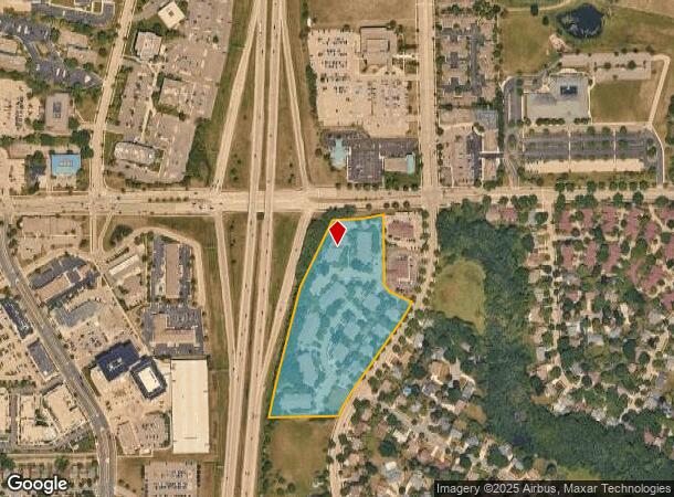
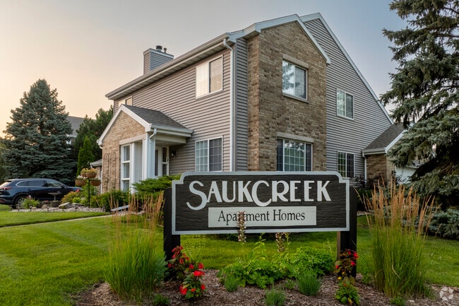
502 N High Point Rd
Madison, WI
Certified Survey Map No 5514 As Recorded
0708-232-1225-7
CERTIFIED SURVEY MAP NO 5514 AS RECORDED IN DANE COUNTY REGISTER OF DEEDS IN VOL 25 PAGE 126 OF CERTIFIED SURVEYS, LOTS 3 & 4.
Commercialnec
Dane
X
Wisconsin
55025C0384G
3
2024
10.32 AC
2024
West Madison
000204
Milwaukee/Madison
264,603 SF
DEMOGRAPHICS near 502 N High Point Rd
1 Mile
3 Mile
5 Mile
2024 Total Population
12,063
72,302
152,375
2029 Population
12,664
75,489
158,359
Pop Growth 2024-2029
+ 4.98%
+ 4.41%
+ 3.93%
Average Age
41
40
39
2024 Total Households
6,066
33,612
68,117
HH Growth 2024-2029
+ 4.90%
+ 4.51%
+ 4.03%
Median Household Inc
$81,520
$87,186
$88,423
Avg Household Size
2.00
2.10
2.20
2024 Avg HH Vehicles
2.00
2.00
2.00
Median Home Value
$390,302
$405,942
$388,211
Median Year Built
1992
1991
1987
Nearby Places
Map Layers
Map Styles
 Street
 Aerial
- Restaurants
- Banks
- Shops
- Fitness
- Groceries
PUBLIC TRANSPORTATION
AIRPORT
Dane County Regional/Truax Field
DRIVE
WALK
Distance
Dane County Regional/Truax Field
25 min
15.6 mi
Freight Ports
Port Milwaukee
DRIVE
WALK
Distance
Port Milwaukee
110 min
92.0 mi
Nearby Properties
Address
Land Use
TOTAL SIZE
Lot Size
Zoning
Address
Land Use
TOTAL SIZE
Lot Size
Zoning
82,796 SF
9.26 AC
SE
Address
Land Use
TOTAL SIZE
Lot Size
Zoning
69,336 SF
26.90 AC
SE
Address
Land Use
TOTAL SIZE
Lot Size
Zoning
354,461 SF
37.40 AC
RMX
Address
Land Use
TOTAL SIZE
Lot Size
Zoning
15.61 AC
Address
Land Use
TOTAL SIZE
Lot Size
Zoning
700,496 SF
23.94 AC
SR-V2
Address
Land Use
TOTAL SIZE
Lot Size
Zoning
56,000 SF
23.87 AC
SE
Address
Land Use
TOTAL SIZE
Lot Size
Zoning
37,909 SF
10.27 AC
SEC
Address
Land Use
TOTAL SIZE
Lot Size
Zoning
203,672 SF
7.34 AC
PD
Address
Land Use
TOTAL SIZE
Lot Size
Zoning
349,680 SF
6.28 AC
TR-U2
Address
Land Use
TOTAL SIZE
Lot Size
Zoning
420,780 SF
10.14 AC
PD
Address
Land Use
TOTAL SIZE
Lot Size
Zoning
8.48 AC
Address
Land Use
TOTAL SIZE
Lot Size
Zoning
1.44 AC
TE
Address
Land Use
TOTAL SIZE
Lot Size
Zoning
169,563 SF
19.82 AC
SEC
Address
Land Use
TOTAL SIZE
Lot Size
Zoning
51,205 SF
9.32 AC
SE
Address
Land Use
TOTAL SIZE
Lot Size
Zoning
27,201 SF
7.65 AC
TR-U2
Address
Land Use
TOTAL SIZE
Lot Size
Zoning
10.12 AC
Address
Land Use
TOTAL SIZE
Lot Size
Zoning
5.95 AC
Address
Land Use
TOTAL SIZE
Lot Size
Zoning
27,201 SF
10.08 AC
TR-U2
Address
Land Use
TOTAL SIZE
Lot Size
Zoning
11.09 AC
Address
Land Use
TOTAL SIZE
Lot Size
Zoning
161,767 SF
4.58 AC
CC-T
Address
Land Use
TOTAL SIZE
Lot Size
Zoning
2.91 AC
SE
Address
Land Use
TOTAL SIZE
Lot Size
Zoning
4.05 AC
CC-T
Address
Land Use
TOTAL SIZE
Lot Size
Zoning
326,724 SF
4.23 AC
PD
Address
Land Use
TOTAL SIZE
Lot Size
Zoning
311,672 SF
4.59 AC
PD
Address
Land Use
TOTAL SIZE
Lot Size
Zoning
254,922 SF
11.97 AC
PD
Address
Land Use
TOTAL SIZE
Lot Size
Zoning
324,920 SF
8.47 AC
PD
Address
Land Use
TOTAL SIZE
Lot Size
Zoning
159,686 SF
7.39 AC
SEC
Address
Land Use
TOTAL SIZE
Lot Size
Zoning
4.37 AC
Address
Land Use
TOTAL SIZE
Lot Size
Zoning
Address
Land Use
TOTAL SIZE
Lot Size
Zoning
320,074 SF
9.28 AC
SR-V2
The World's #1 Commercial Real Estate Marketplace
Connect with us
© 2025 CoStar Group
The information above has been obtained from sources believed reliable. While we do not doubt its accuracy we have not verified it and make no guarantee, warranty or representation about it. It is your responsibility to independently confirm its accuracy and completeness. Any projections, opinions, assumptions, or estimates used are for example only and do not represent the current or future performance of the property. The value of this transaction to you depends on tax and other factors which should be evaluated by your tax, financial, and legal advisors. You and your advisors should conduct a careful, independent investigation of the property to determine to your satisfaction the suitability of the property for your needs.