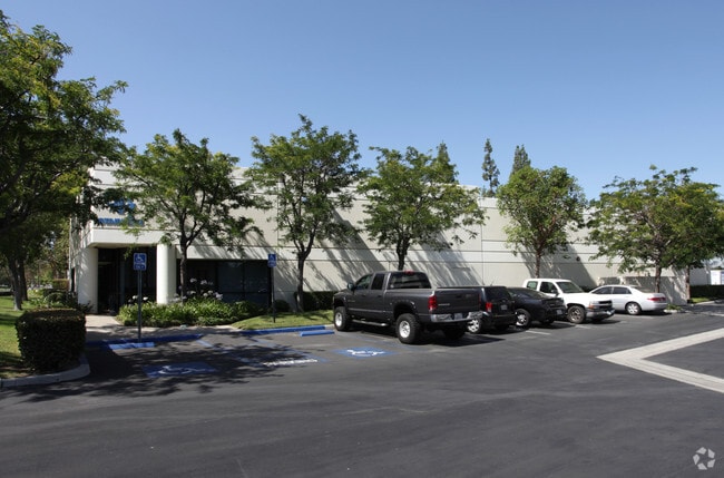
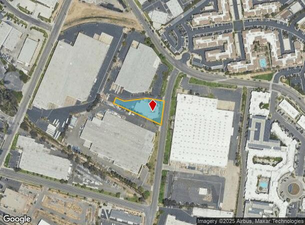
Property Record
502 N Sheridan St, Corona, CA 92878
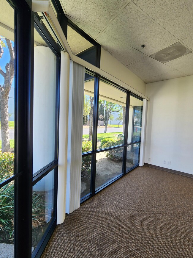
Current Lease Availabilities
NEARBY LISTINGS FOR SALE OR LEASE
Property Detail
502 N Sheridan St
119-290-048
.69 ACRES IN PAR 2 PM 158/023 PM 23210
Lightindustrial
Riverside
X
California
06065C0689H
2
2024
0.69 AC
2025
Corona/Eastvale
040616
Inland Empire (California)
11,511 SF
Riverside-San Bernardino-Ontario, CA
DEMOGRAPHICS near 502 N Sheridan St
1 Mile
3 Mile
5 Mile
2024 Total Population
16,619
123,793
232,952
2029 Population
17,366
129,874
244,230
Pop Growth 2024-2029
+ 4.49%
+ 4.91%
+ 4.84%
Average Age
33
37
37
2024 Total Households
4,928
35,345
66,690
HH Growth 2024-2029
+ 3.75%
+ 4.48%
+ 4.35%
Median Household Inc
$66,316
$86,658
$99,199
Avg Household Size
3.20
3.20
3.30
2024 Avg HH Vehicles
2.00
2.00
2.00
Median Home Value
$445,249
$593,858
$645,226
Median Year Built
1988
1983
1988
Nearby Places
Map Layers
Map Styles
 Street
 Aerial
- Restaurants
- Banks
- Shops
- Fitness
- Groceries
PUBLIC TRANSPORTATION
COMMUTER RAIL
North Main Corona (91 Line - Southern California Regional Rail Authority (Metrolink), Inland Empire-Orange County Line - Southern California Regional Rail Authority (Metrolink))
DRIVE
WALK
Distance
North Main Corona (91 Line - Southern California Regional Rail Authority (Metrolink), Inland Empire-Orange County Line - Southern California Regional Rail Authority (Metrolink))
2 min
12 min
0.6 mi
West Corona (91 Line - Southern California Regional Rail Authority (Metrolink), Inland Empire-Orange County Line - Southern California Regional Rail Authority (Metrolink))
DRIVE
WALK
Distance
West Corona (91 Line - Southern California Regional Rail Authority (Metrolink), Inland Empire-Orange County Line - Southern California Regional Rail Authority (Metrolink))
7 min
3.6 mi
AIRPORT
Ontario International
DRIVE
WALK
Distance
Ontario International
21 min
14.2 mi
John Wayne/Orange County
DRIVE
WALK
Distance
John Wayne/Orange County
35 min
28.6 mi
Long Beach (Daugherty Field)
DRIVE
WALK
Distance
Long Beach (Daugherty Field)
52 min
43.1 mi
Freight Ports
Port of Long Beach
DRIVE
WALK
Distance
Port of Long Beach
58 min
42.7 mi
Nearby Properties
Address
Land Use
TOTAL SIZE
Lot Size
Zoning
Address
Land Use
TOTAL SIZE
Lot Size
Zoning
32,924 SF
24.04 AC
Address
Land Use
TOTAL SIZE
Lot Size
Zoning
12.69 AC
Address
Land Use
TOTAL SIZE
Lot Size
Zoning
91,619 SF
12.54 AC
HDR
Address
Land Use
TOTAL SIZE
Lot Size
Zoning
29,695 SF
18.71 AC
R3
Address
Land Use
TOTAL SIZE
Lot Size
Zoning
335,820 SF
15.18 AC
Address
Land Use
TOTAL SIZE
Lot Size
Zoning
205,235 SF
10.30 AC
Address
Land Use
TOTAL SIZE
Lot Size
Zoning
364,193 SF
23.77 AC
Address
Land Use
TOTAL SIZE
Lot Size
Zoning
71,440 SF
14.37 AC
Address
Land Use
TOTAL SIZE
Lot Size
Zoning
289,297 SF
13.28 AC
M3
Address
Land Use
TOTAL SIZE
Lot Size
Zoning
186,190 SF
9.79 AC
Address
Land Use
TOTAL SIZE
Lot Size
Zoning
164,712 SF
10 AC
R3
Address
Land Use
TOTAL SIZE
Lot Size
Zoning
173,676 SF
10.96 AC
R3
Address
Land Use
TOTAL SIZE
Lot Size
Zoning
24,144 SF
13.34 AC
R3
Address
Land Use
TOTAL SIZE
Lot Size
Zoning
245,658 SF
15.38 AC
PD
Address
Land Use
TOTAL SIZE
Lot Size
Zoning
182,066 SF
9.31 AC
Address
Land Use
TOTAL SIZE
Lot Size
Zoning
152,369 SF
5.38 AC
Address
Land Use
TOTAL SIZE
Lot Size
Zoning
8.80 AC
R3
Address
Land Use
TOTAL SIZE
Lot Size
Zoning
150,404 SF
8.02 AC
Address
Land Use
TOTAL SIZE
Lot Size
Zoning
421,898 SF
3 AC
Address
Land Use
TOTAL SIZE
Lot Size
Zoning
217,299 SF
7.41 AC
Address
Land Use
TOTAL SIZE
Lot Size
Zoning
141,280 SF
9.31 AC
Address
Land Use
TOTAL SIZE
Lot Size
Zoning
171,707 SF
8.55 AC
Address
Land Use
TOTAL SIZE
Lot Size
Zoning
149,389 SF
6.72 AC
Address
Land Use
TOTAL SIZE
Lot Size
Zoning
359,304 SF
8.86 AC
R3
Address
Land Use
TOTAL SIZE
Lot Size
Zoning
154,581 SF
8.30 AC
Address
Land Use
TOTAL SIZE
Lot Size
Zoning
152,756 SF
7.07 AC
Address
Land Use
TOTAL SIZE
Lot Size
Zoning
159,517 SF
7.81 AC
Address
Land Use
TOTAL SIZE
Lot Size
Zoning
52,928 SF
9.69 AC
Address
Land Use
TOTAL SIZE
Lot Size
Zoning
138,800 SF
10 AC
M4
The World's #1 Commercial Real Estate Marketplace
Connect with us
© 2026 CoStar Group
The information above has been obtained from sources believed reliable. While we do not doubt its accuracy we have not verified it and make no guarantee, warranty or representation about it. It is your responsibility to independently confirm its accuracy and completeness. Any projections, opinions, assumptions, or estimates used are for example only and do not represent the current or future performance of the property. The value of this transaction to you depends on tax and other factors which should be evaluated by your tax, financial, and legal advisors. You and your advisors should conduct a careful, independent investigation of the property to determine to your satisfaction the suitability of the property for your needs.