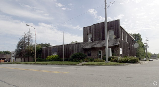
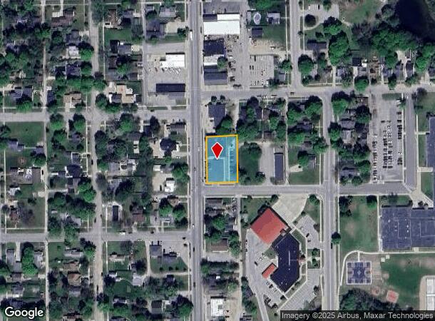
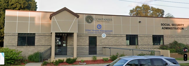
Property Record
502 N State St, Big Rapids, MI 49307
NEARBY LISTINGS FOR SALE OR LEASE
Property Detail
502 N State St
Big Rapids, MI
Warren And Bronson's First Subdivision
5417-011-303-002
000502 N STATE STREET: WARREN AND BRONSON'S FIRST SUBDIVISION -- BLK 2, LOTS 33 THRU 40 INCL
Commercialnec
Mecosta
X
Michigan
26107C0153C
33-40
2024
0.55 AC
2025
Michigan North Central Area
960500
Other Market Areas
17,220 SF
DEMOGRAPHICS near 502 N State St
1 Mile
3 Mile
5 Mile
2024 Total Population
4,861
12,071
15,791
2029 Population
5,099
12,849
16,760
Pop Growth 2024-2029
+ 4.90%
+ 6.45%
+ 6.14%
Average Age
36
34
36
2024 Total Households
2,173
4,869
6,333
HH Growth 2024-2029
+ 4.74%
+ 6.92%
+ 6.51%
Median Household Inc
$39,576
$33,603
$41,561
Avg Household Size
2.10
2.10
2.20
2024 Avg HH Vehicles
2.00
2.00
2.00
Median Home Value
$128,313
$156,566
$160,767
Median Year Built
1965
1977
1978
Nearby Places
Map Layers
Map Styles
 Street
 Aerial
- Restaurants
- Banks
- Shops
- Fitness
- Groceries
SALE & LEASE HISTORY
LISTING DATE
SALE/LEASE

Feb 24, 2025
For Lease
Nearby Properties
Address
Land Use
TOTAL SIZE
Lot Size
Zoning
Address
Land Use
TOTAL SIZE
Lot Size
Zoning
270,869 SF
19.75 AC
Address
Land Use
TOTAL SIZE
Lot Size
Zoning
56.64 AC
Address
Land Use
TOTAL SIZE
Lot Size
Zoning
205,711 SF
30.37 AC
Address
Land Use
TOTAL SIZE
Lot Size
Zoning
16.08 AC
Address
Land Use
TOTAL SIZE
Lot Size
Zoning
20,760 SF
36.80 AC
Address
Land Use
TOTAL SIZE
Lot Size
Zoning
95,044 SF
12.16 AC
Address
Land Use
TOTAL SIZE
Lot Size
Zoning
9.65 AC
Address
Land Use
TOTAL SIZE
Lot Size
Zoning
29.09 AC
Address
Land Use
TOTAL SIZE
Lot Size
Zoning
Address
Land Use
TOTAL SIZE
Lot Size
Zoning
23,240 SF
7.41 AC
Address
Land Use
TOTAL SIZE
Lot Size
Zoning
18,387 SF
6.21 AC
Address
Land Use
TOTAL SIZE
Lot Size
Zoning
10,080 SF
18.85 AC
Address
Land Use
TOTAL SIZE
Lot Size
Zoning
10,443 SF
5.81 AC
Address
Land Use
TOTAL SIZE
Lot Size
Zoning
14.05 AC
Address
Land Use
TOTAL SIZE
Lot Size
Zoning
60,416 SF
5.40 AC
Address
Land Use
TOTAL SIZE
Lot Size
Zoning
89,079 SF
6.90 AC
Address
Land Use
TOTAL SIZE
Lot Size
Zoning
14,094 SF
9.43 AC
Address
Land Use
TOTAL SIZE
Lot Size
Zoning
35.44 AC
Address
Land Use
TOTAL SIZE
Lot Size
Zoning
Address
Land Use
TOTAL SIZE
Lot Size
Zoning
103,416 SF
23.68 AC
Address
Land Use
TOTAL SIZE
Lot Size
Zoning
Address
Land Use
TOTAL SIZE
Lot Size
Zoning
263.37 AC
Address
Land Use
TOTAL SIZE
Lot Size
Zoning
11,319 SF
3.41 AC
Address
Land Use
TOTAL SIZE
Lot Size
Zoning
12.54 AC
Address
Land Use
TOTAL SIZE
Lot Size
Zoning
25,434 SF
4.39 AC
Address
Land Use
TOTAL SIZE
Lot Size
Zoning
131,210 SF
6.11 AC
Address
Land Use
TOTAL SIZE
Lot Size
Zoning
12,960 SF
6.14 AC
Address
Land Use
TOTAL SIZE
Lot Size
Zoning
20,300 SF
6.36 AC
Address
Land Use
TOTAL SIZE
Lot Size
Zoning
Address
Land Use
TOTAL SIZE
Lot Size
Zoning
39,316 SF
3.54 AC
The World's #1 Commercial Real Estate Marketplace
Connect with us
© 2026 CoStar Group
The information above has been obtained from sources believed reliable. While we do not doubt its accuracy we have not verified it and make no guarantee, warranty or representation about it. It is your responsibility to independently confirm its accuracy and completeness. Any projections, opinions, assumptions, or estimates used are for example only and do not represent the current or future performance of the property. The value of this transaction to you depends on tax and other factors which should be evaluated by your tax, financial, and legal advisors. You and your advisors should conduct a careful, independent investigation of the property to determine to your satisfaction the suitability of the property for your needs.