Property Record
502 S Main St, Mauldin, SC 29662
NEARBY LISTINGS FOR SALE OR LEASE
Property Detail
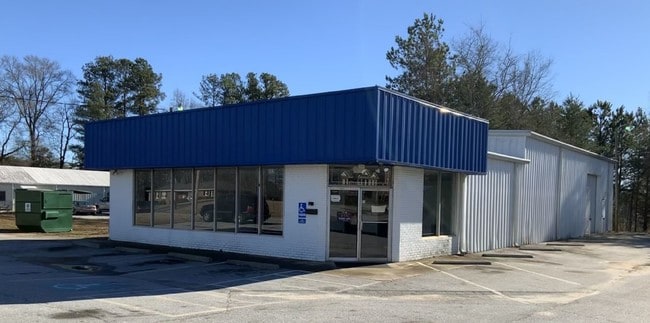
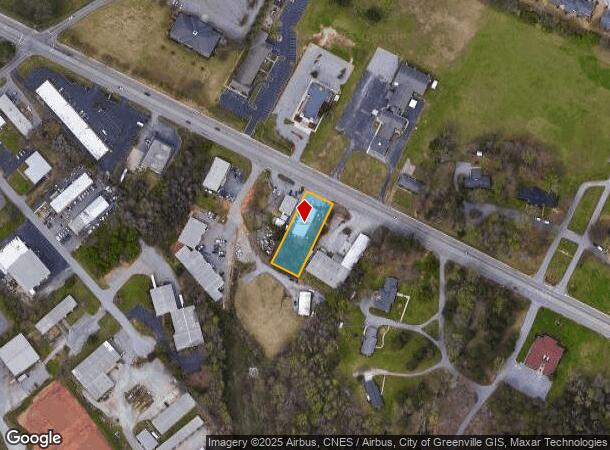
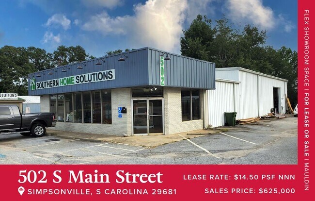
502 S Main St
Greenville-Anderson-Mauldin, SC
Property Of Manldin Auto Parts
0292.00-01-015.01
MAP 0292.00
Storebuilding
Greenville
X
South Carolina
45045C0418E
015.01
2025
0.58 AC
2024
W Butler/Mauldin
002903
Greenville/Spartanburg
DEMOGRAPHICS near 502 S Main St
1 Mile
3 Mile
5 Mile
2024 Total Population
4,630
49,116
132,467
2029 Population
5,089
54,174
146,412
Pop Growth 2024-2029
+ 9.91%
+ 10.30%
+ 10.53%
Average Age
42
40
40
2024 Total Households
1,975
19,971
52,657
HH Growth 2024-2029
+ 9.92%
+ 10.41%
+ 10.67%
Median Household Inc
$66,211
$81,295
$84,139
Avg Household Size
2.30
2.40
2.50
2024 Avg HH Vehicles
2.00
2.00
2.00
Median Home Value
$184,680
$237,518
$255,528
Median Year Built
1993
1996
1998
Nearby Places
Map Layers
Map Styles
 Street
 Aerial
- Restaurants
- Banks
- Shops
- Fitness
- Groceries
PUBLIC TRANSPORTATION
AIRPORT
Greenville Spartanburg International
DRIVE
WALK
Distance
Greenville Spartanburg International
19 min
13.0 mi
Freight Ports
North Charleston Terminal
DRIVE
WALK
Distance
North Charleston Terminal
215 min
193.3 mi
SALE & LEASE HISTORY
LISTING DATE
SALE/LEASE

Sep 25, 2016
For Lease
Sep 08, 2021
For Sale
Sep 08, 2021
For Lease
Oct 09, 2019
For Sale
Feb 07, 2019
For Lease
Nearby Properties
Address
Land Use
TOTAL SIZE
Lot Size
Zoning
Address
Land Use
TOTAL SIZE
Lot Size
Zoning
22.50 AC
S1
Address
Land Use
TOTAL SIZE
Lot Size
Zoning
10.20 AC
R12
Address
Land Use
TOTAL SIZE
Lot Size
Zoning
10.35 AC
R12
Address
Land Use
TOTAL SIZE
Lot Size
Zoning
23.23 AC
Address
Land Use
TOTAL SIZE
Lot Size
Zoning
11.91 AC
RM20
Address
Land Use
TOTAL SIZE
Lot Size
Zoning
7.53 AC
S1
Address
Land Use
TOTAL SIZE
Lot Size
Zoning
11.05 AC
S1
Address
Land Use
TOTAL SIZE
Lot Size
Zoning
6.27 AC
UVD
Address
Land Use
TOTAL SIZE
Lot Size
Zoning
12.31 AC
Address
Land Use
TOTAL SIZE
Lot Size
Zoning
17.59 AC
Address
Land Use
TOTAL SIZE
Lot Size
Zoning
29.21 AC
I1
Address
Land Use
TOTAL SIZE
Lot Size
Zoning
Address
Land Use
TOTAL SIZE
Lot Size
Zoning
5 AC
R12
Address
Land Use
TOTAL SIZE
Lot Size
Zoning
Address
Land Use
TOTAL SIZE
Lot Size
Zoning
10.78 AC
I1
Address
Land Use
TOTAL SIZE
Lot Size
Zoning
24.12 AC
S1
Address
Land Use
TOTAL SIZE
Lot Size
Zoning
195.23 AC
RRROW
Address
Land Use
TOTAL SIZE
Lot Size
Zoning
9.46 AC
I1
Address
Land Use
TOTAL SIZE
Lot Size
Zoning
12.43 AC
RS
Address
Land Use
TOTAL SIZE
Lot Size
Zoning
1,539 SF
11.20 AC
C2
Address
Land Use
TOTAL SIZE
Lot Size
Zoning
8.51 AC
S1
Address
Land Use
TOTAL SIZE
Lot Size
Zoning
50.13 AC
RM,S1
Address
Land Use
TOTAL SIZE
Lot Size
Zoning
50.76 AC
PDC
Address
Land Use
TOTAL SIZE
Lot Size
Zoning
96.14 AC
NZ
Address
Land Use
TOTAL SIZE
Lot Size
Zoning
26.30 AC
ROI
Address
Land Use
TOTAL SIZE
Lot Size
Zoning
Address
Land Use
TOTAL SIZE
Lot Size
Zoning
51.30 AC
RS
Address
Land Use
TOTAL SIZE
Lot Size
Zoning
2.86 AC
S1
Address
Land Use
TOTAL SIZE
Lot Size
Zoning
8.23 AC
S1
Address
Land Use
TOTAL SIZE
Lot Size
Zoning
6.50 AC
RM
The World's #1 Commercial Real Estate Marketplace
Connect with us
© 2025 CoStar Group
The information above has been obtained from sources believed reliable. While we do not doubt its accuracy we have not verified it and make no guarantee, warranty or representation about it. It is your responsibility to independently confirm its accuracy and completeness. Any projections, opinions, assumptions, or estimates used are for example only and do not represent the current or future performance of the property. The value of this transaction to you depends on tax and other factors which should be evaluated by your tax, financial, and legal advisors. You and your advisors should conduct a careful, independent investigation of the property to determine to your satisfaction the suitability of the property for your needs.