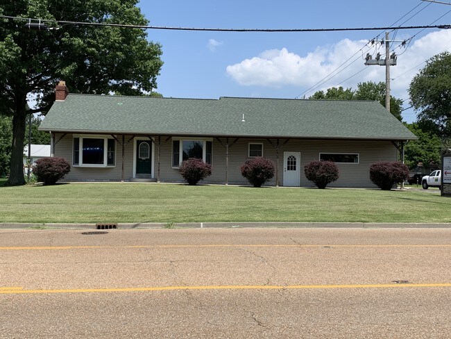
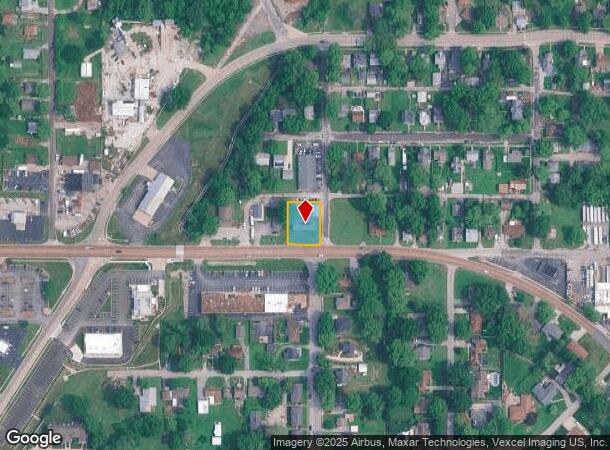
Property Record
502 W Highway 50, O Fallon, IL 62269
NEARBY LISTINGS FOR SALE OR LEASE
Property Detail
502 W Highway 50
St. Louis
Tiedemanns
St. Louis, MO-IL
TIEDEMANNS 2ND ADD. LOT/SEC-20 LT 19 & 20 DOC A02683076 EX PT FOR RD AS IN 2971-99
04-30.0-411-014
St. Clair
Specialpurpose
Illinois
2024
19,20
2024
0.30 AC
504354
Illinois
1,232 SF
DEMOGRAPHICS near 502 W Highway 50
1 Mile
3 Mile
5 Mile
2024 Total Population
7,994
31,701
66,667
2029 Population
7,651
30,448
64,126
Pop Growth 2024-2029
(4.29%)
(3.95%)
(3.81%)
Average Age
40
40
39
2024 Total Households
3,366
12,671
26,035
HH Growth 2024-2029
(4.22%)
(3.87%)
(3.83%)
Median Household Inc
$84,728
$100,518
$96,203
Avg Household Size
2.40
2.50
2.50
2024 Avg HH Vehicles
2.00
2.00
2.00
Median Home Value
$204,678
$243,342
$234,914
Median Year Built
1980
1992
1993
Nearby Places
Map Layers
Map Styles
 Street
 Aerial
- Restaurants
- Banks
- Shops
- Fitness
- Groceries
PUBLIC TRANSPORTATION
COMMUTER RAIL
Shiloh-Scott (Lambert Airport Shiloh-Scott - St. Louis MetroLink (MetroLink))
DRIVE
WALK
Distance
Shiloh-Scott (Lambert Airport Shiloh-Scott - St. Louis MetroLink (MetroLink))
10 min
5.1 mi
College (Lambert Airport Shiloh-Scott - St. Louis MetroLink (MetroLink))
DRIVE
WALK
Distance
College (Lambert Airport Shiloh-Scott - St. Louis MetroLink (MetroLink))
14 min
7.1 mi
AIRPORT
Scott AFB/Midamerica St Louis
DRIVE
WALK
Distance
Scott AFB/Midamerica St Louis
19 min
7.6 mi
St Louis Lambert International
DRIVE
WALK
Distance
St Louis Lambert International
41 min
29.2 mi
Freight Ports
Port Milwaukee
DRIVE
WALK
Distance
Port Milwaukee
416 min
366.2 mi
SALE & LEASE HISTORY
LISTING DATE
SALE/LEASE

Aug 02, 2019
For Sale
Nearby Properties
Address
Land Use
TOTAL SIZE
Lot Size
Zoning
Address
Land Use
TOTAL SIZE
Lot Size
Zoning
70,515 SF
27.95 AC
Address
Land Use
TOTAL SIZE
Lot Size
Zoning
21.84 AC
Address
Land Use
TOTAL SIZE
Lot Size
Zoning
Address
Land Use
TOTAL SIZE
Lot Size
Zoning
9,384 SF
15.93 AC
Address
Land Use
TOTAL SIZE
Lot Size
Zoning
2,937 SF
16.68 AC
Address
Land Use
TOTAL SIZE
Lot Size
Zoning
Address
Land Use
TOTAL SIZE
Lot Size
Zoning
17,676 SF
3.09 AC
Address
Land Use
TOTAL SIZE
Lot Size
Zoning
207,910 SF
13.42 AC
Address
Land Use
TOTAL SIZE
Lot Size
Zoning
30.86 AC
Address
Land Use
TOTAL SIZE
Lot Size
Zoning
167,235 SF
18.91 AC
Address
Land Use
TOTAL SIZE
Lot Size
Zoning
Address
Land Use
TOTAL SIZE
Lot Size
Zoning
10.08 AC
Address
Land Use
TOTAL SIZE
Lot Size
Zoning
Address
Land Use
TOTAL SIZE
Lot Size
Zoning
3.24 AC
Address
Land Use
TOTAL SIZE
Lot Size
Zoning
29,906 SF
4.24 AC
Address
Land Use
TOTAL SIZE
Lot Size
Zoning
140,850 SF
16.71 AC
Address
Land Use
TOTAL SIZE
Lot Size
Zoning
142,369 SF
12.01 AC
Address
Land Use
TOTAL SIZE
Lot Size
Zoning
8,141 SF
16.74 AC
Address
Land Use
TOTAL SIZE
Lot Size
Zoning
Address
Land Use
TOTAL SIZE
Lot Size
Zoning
9.63 AC
Address
Land Use
TOTAL SIZE
Lot Size
Zoning
1.94 AC
Address
Land Use
TOTAL SIZE
Lot Size
Zoning
81.90 AC
Address
Land Use
TOTAL SIZE
Lot Size
Zoning
7,004 SF
9.59 AC
Address
Land Use
TOTAL SIZE
Lot Size
Zoning
7.82 AC
Address
Land Use
TOTAL SIZE
Lot Size
Zoning
Address
Land Use
TOTAL SIZE
Lot Size
Zoning
37,197 SF
6.20 AC
Address
Land Use
TOTAL SIZE
Lot Size
Zoning
37,201 SF
4.52 AC
Address
Land Use
TOTAL SIZE
Lot Size
Zoning
125,576 SF
3.48 AC
Address
Land Use
TOTAL SIZE
Lot Size
Zoning
3.57 AC
Address
Land Use
TOTAL SIZE
Lot Size
Zoning
11,100 SF
1.53 AC
The World's #1 Commercial Real Estate Marketplace
Connect with us
© 2025 CoStar Group
The information above has been obtained from sources believed reliable. While we do not doubt its accuracy we have not verified it and make no guarantee, warranty or representation about it. It is your responsibility to independently confirm its accuracy and completeness. Any projections, opinions, assumptions, or estimates used are for example only and do not represent the current or future performance of the property. The value of this transaction to you depends on tax and other factors which should be evaluated by your tax, financial, and legal advisors. You and your advisors should conduct a careful, independent investigation of the property to determine to your satisfaction the suitability of the property for your needs.