Property Record
502 W Hudson Rd, Rogers, AR 72756
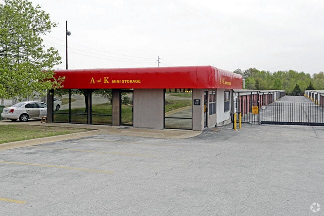

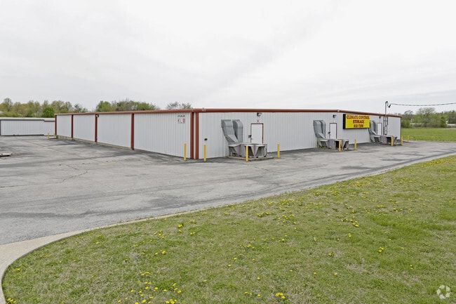
Property Detail
502 W Hudson Rd
02-00744-016
LEGAL DESCRIPTION - TRACT 3C A PART OF TRACT 3 OF THE BOUNDARY SURVEY LINDSEY SEXTON BALL & MONTGOMERY TRACTS HIGHWAY 62 & 102 ROGERS ARKANSAS AS RECORDED IN BOOK 6 PAGE 271 BENTON COUNTY ARKANSAS DESCRIBED AS BEGINNING AT THE NORTHEAST CORNER OF SAI
Publicstorage
Benton
AE The base floodplain where base flood elevations are provided. AE Zones are now used on new format FIRMs instead of A1-A30 Zones.
Arkansas
2025
3.76 AC
2025
East Rogers
020201
Fayetteville/Springdale/Rogers
63,400 SF
Fayetteville-Springdale-Rogers, AR
NEARBY LISTINGS FOR SALE OR LEASE
DEMOGRAPHICS near 502 W Hudson Rd
1 mile
3 mile
5 mile
2025 Total Population
5,075
42,101
92,789
2030 Population
5,534
46,180
102,489
Pop Growth 2025-2030
+ 9.04%
+ 9.69%
+ 10.45%
Average Age
36
38
37
2025 Total Households
1,682
15,240
34,643
HH Growth 2025-2030
+ 9.33%
+ 10.02%
+ 10.86%
Median Household Inc
$73,895
$70,628
$75,504
Avg Household Size
2.70
2.70
2.60
2025 Avg HH Vehicles
2.00
2.00
2.00
Median Home Value
$289,911
$284,928
$323,184
Median Year Built
1988
1989
1994
Nearby Places
Map Layers
Map Styles
 Street
 Aerial
Layers
 Traffic
 Biking
Places
Listings with unknown addresses are not visible on the map
- Restaurants
- Banks
- Shops
- Fitness
- Groceries
PUBLIC TRANSPORTATION
AIRPORT
Northwest Arkansas Ntl
Drive
Walk
Distance
Northwest Arkansas Ntl
31 min
15.9 mi
Freight Ports
Tulsa Port of Inola
Drive
Walk
Distance
Tulsa Port of Inola
118 min
101.1 mi
Nearby Properties
Address
Land Use
TOTAL SIZE
Lot Size
Zoning
Address
Land Use
TOTAL SIZE
Lot Size
Zoning
117,522 SF
0.12 AC
Address
Land Use
TOTAL SIZE
Lot Size
Zoning
746,783 SF
77.03 AC
Address
Land Use
TOTAL SIZE
Lot Size
Zoning
542,873 SF
16.52 AC
Address
Land Use
TOTAL SIZE
Lot Size
Zoning
573,476 SF
57.80 AC
Address
Land Use
TOTAL SIZE
Lot Size
Zoning
249,843 SF
19.21 AC
Address
Land Use
TOTAL SIZE
Lot Size
Zoning
214,791 SF
9.13 AC
Address
Land Use
TOTAL SIZE
Lot Size
Zoning
156,100 SF
7.89 AC
Address
Land Use
TOTAL SIZE
Lot Size
Zoning
274,312 SF
12.24 AC
Address
Land Use
TOTAL SIZE
Lot Size
Zoning
152,759 SF
12.01 AC
Address
Land Use
TOTAL SIZE
Lot Size
Zoning
114,250 SF
7.54 AC
Address
Land Use
TOTAL SIZE
Lot Size
Zoning
117,522 SF
13.66 AC
Address
Land Use
TOTAL SIZE
Lot Size
Zoning
231,576 SF
15.18 AC
Address
Land Use
TOTAL SIZE
Lot Size
Zoning
102,477 SF
7.15 AC
Address
Land Use
TOTAL SIZE
Lot Size
Zoning
46,851 SF
4.28 AC
Address
Land Use
TOTAL SIZE
Lot Size
Zoning
74,243 SF
14.03 AC
Address
Land Use
TOTAL SIZE
Lot Size
Zoning
205,851 SF
20.13 AC
Address
Land Use
TOTAL SIZE
Lot Size
Zoning
263,095 SF
13.17 AC
Address
Land Use
TOTAL SIZE
Lot Size
Zoning
402,500 SF
19.54 AC
Address
Land Use
TOTAL SIZE
Lot Size
Zoning
191,610 SF
43 AC
Address
Land Use
TOTAL SIZE
Lot Size
Zoning
112,935 SF
6.75 AC
Address
Land Use
TOTAL SIZE
Lot Size
Zoning
195,563 SF
15.49 AC
Address
Land Use
TOTAL SIZE
Lot Size
Zoning
141,332 SF
18.26 AC
Address
Land Use
TOTAL SIZE
Lot Size
Zoning
109,683 SF
Address
Land Use
TOTAL SIZE
Lot Size
Zoning
101,690 SF
8.76 AC
Address
Land Use
TOTAL SIZE
Lot Size
Zoning
123,791 SF
5.64 AC
Address
Land Use
TOTAL SIZE
Lot Size
Zoning
123,879 SF
5.31 AC
Address
Land Use
TOTAL SIZE
Lot Size
Zoning
143,368 SF
11.72 AC
Address
Land Use
TOTAL SIZE
Lot Size
Zoning
160,798 SF
14.84 AC
Address
Land Use
TOTAL SIZE
Lot Size
Zoning
57,609 SF
8.53 AC
Address
Land Use
TOTAL SIZE
Lot Size
Zoning
123,568 SF
12.12 AC
The World's #1 Commercial Real Estate Marketplace
Connect with us
© 2026 CoStar Group
The information above has been obtained from sources believed reliable. While we do not doubt its accuracy we have not verified it and make no guarantee, warranty or representation about it. It is your responsibility to independently confirm its accuracy and completeness. Any projections, opinions, assumptions, or estimates used are for example only and do not represent the current or future performance of the property. The value of this transaction to you depends on tax and other factors which should be evaluated by your tax, financial, and legal advisors. You and your advisors should conduct a careful, independent investigation of the property to determine to your satisfaction the suitability of the property for your needs.