Property Record
502 W Markey Rd, Belton, MO 64012


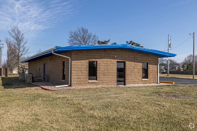
Property Detail
502 W Markey Rd
1402085
PT BLK 16 CIM TR AKA PT NW BG617E&40N NWCR S245X195
Officebuilding
Cass
B and X Area of moderate flood hazard, usually the area between the limits of the 100-year and 500-year floods.
Missouri
2024
1.17 AC
2025
Cass County
060100
Kansas City
2,356 SF
Kansas City, MO-KS
NEARBY LISTINGS FOR SALE OR LEASE
DEMOGRAPHICS near 502 W Markey Rd
1 mile
3 mile
5 mile
2025 Total Population
5,997
33,683
79,745
2030 Population
6,182
35,046
82,576
Pop Growth 2025-2030
+ 3.08%
+ 4.05%
+ 3.55%
Average Age
37
38
40
2025 Total Households
2,244
13,423
30,917
HH Growth 2025-2030
+ 3.25%
+ 4.29%
+ 3.63%
Median Household Inc
$72,873
$62,673
$73,140
Avg Household Size
2.60
2.50
2.50
2025 Avg HH Vehicles
2.00
2.00
2.00
Median Home Value
$158,695
$190,692
$263,180
Median Year Built
1977
1988
1988
Nearby Places
Map Layers
Map Styles
 Street
 Aerial
Layers
 Traffic
 Biking
Places
Listings with unknown addresses are not visible on the map
- Restaurants
- Banks
- Shops
- Fitness
- Groceries
SALE & LEASE HISTORY
LISTING DATE
SALE/LEASE

Jun 15, 2017
For Sale
Jan 19, 2025
For Lease
Aug 14, 2023
For Sale
Nearby Properties
Address
Land Use
TOTAL SIZE
Lot Size
Zoning
Address
Land Use
TOTAL SIZE
Lot Size
Zoning
1,314,506 SF
174 AC
Address
Land Use
TOTAL SIZE
Lot Size
Zoning
38.18 AC
Address
Land Use
TOTAL SIZE
Lot Size
Zoning
11.65 AC
Address
Land Use
TOTAL SIZE
Lot Size
Zoning
4,490 SF
27.52 AC
Address
Land Use
TOTAL SIZE
Lot Size
Zoning
456,840 SF
29.46 AC
Address
Land Use
TOTAL SIZE
Lot Size
Zoning
915,528 SF
72.47 AC
Address
Land Use
TOTAL SIZE
Lot Size
Zoning
319,892 SF
Address
Land Use
TOTAL SIZE
Lot Size
Zoning
366,600 SF
9 AC
Address
Land Use
TOTAL SIZE
Lot Size
Zoning
646,513 SF
113.86 AC
Address
Land Use
TOTAL SIZE
Lot Size
Zoning
447,462 SF
37.91 AC
Address
Land Use
TOTAL SIZE
Lot Size
Zoning
631,055 SF
71.76 AC
Address
Land Use
TOTAL SIZE
Lot Size
Zoning
267,428 SF
Address
Land Use
TOTAL SIZE
Lot Size
Zoning
227,676 SF
15.86 AC
Address
Land Use
TOTAL SIZE
Lot Size
Zoning
425,779 SF
23.23 AC
Address
Land Use
TOTAL SIZE
Lot Size
Zoning
372,085 SF
17.16 AC
Address
Land Use
TOTAL SIZE
Lot Size
Zoning
24,132 SF
36.55 AC
Address
Land Use
TOTAL SIZE
Lot Size
Zoning
446,900 SF
19.33 AC
Address
Land Use
TOTAL SIZE
Lot Size
Zoning
944,109 SF
17.75 AC
Address
Land Use
TOTAL SIZE
Lot Size
Zoning
90,842 SF
9 AC
Address
Land Use
TOTAL SIZE
Lot Size
Zoning
53,306 SF
6.70 AC
Address
Land Use
TOTAL SIZE
Lot Size
Zoning
313,997 SF
20.57 AC
Address
Land Use
TOTAL SIZE
Lot Size
Zoning
504,100 SF
39.25 AC
Address
Land Use
TOTAL SIZE
Lot Size
Zoning
303,625 SF
Address
Land Use
TOTAL SIZE
Lot Size
Zoning
94,080 SF
5.83 AC
Address
Land Use
TOTAL SIZE
Lot Size
Zoning
17,590 SF
18.30 AC
Address
Land Use
TOTAL SIZE
Lot Size
Zoning
80,976 SF
1.82 AC
Address
Land Use
TOTAL SIZE
Lot Size
Zoning
253,575 SF
43.62 AC
Address
Land Use
TOTAL SIZE
Lot Size
Zoning
402,609 SF
15.11 AC
Address
Land Use
TOTAL SIZE
Lot Size
Zoning
611,460 SF
23.70 AC
Address
Land Use
TOTAL SIZE
Lot Size
Zoning
94,123 SF
37.36 AC
The World's #1 Commercial Real Estate Marketplace
Connect with us
© 2026 CoStar Group
The information above has been obtained from sources believed reliable. While we do not doubt its accuracy we have not verified it and make no guarantee, warranty or representation about it. It is your responsibility to independently confirm its accuracy and completeness. Any projections, opinions, assumptions, or estimates used are for example only and do not represent the current or future performance of the property. The value of this transaction to you depends on tax and other factors which should be evaluated by your tax, financial, and legal advisors. You and your advisors should conduct a careful, independent investigation of the property to determine to your satisfaction the suitability of the property for your needs.