Property Record
5020 19 1/2 Ave, Riverdale, CA 93656
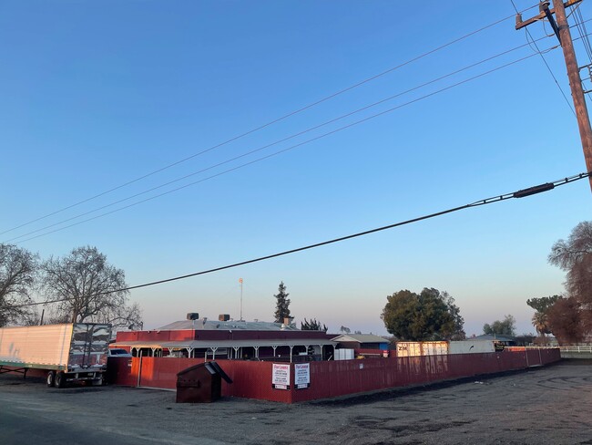

This Property Is For Sale
NEARBY LISTINGS FOR SALE OR LEASE
-
-
View all Riverdale listings for sale on LoopNet.com
Property Detail
5020 19 1/2 Ave
Hanford-Corcoran, CA
Laguna De Tache Grant
004-070-049-000
SEC 04/18/20 BEGINNING AT A POINT 180 FT SOUTH OF SOUTHERN PACIFIC RAILROAD RIGHT OF WAY BEING ON EAST LINE OF LOT 6, THENCE WEST 242 FT, THENCE NORTH 135 FT, THENCE EAST 242 FT, THENCE SOUTH 135 FT TO POINT OF BEGINNING EXCEPT WEST 50 FT OF NORTH 50
Restaurantbuilding
Kings
X
California
06019C2900J
6
2024
0.69 AC
2025
Outlying Kings County
000200
Fresno
5,404 SF
DEMOGRAPHICS near 5020 19 1/2 Ave
1 Mile
3 Mile
5 Mile
2024 Total Population
147
2,546
6,902
2029 Population
145
2,540
6,858
Pop Growth 2024-2029
(1.36%)
(0.24%)
(0.64%)
Average Age
37
36
36
2024 Total Households
46
761
2,049
HH Growth 2024-2029
(2.17%)
(0.26%)
(0.73%)
Median Household Inc
$63,333
$62,443
$60,644
Avg Household Size
3.20
3.30
3.30
2024 Avg HH Vehicles
3.00
3.00
2.00
Median Home Value
$381,249
$351,234
$353,392
Median Year Built
1975
1973
1973
Nearby Places
- Restaurants
- Banks
- Shops
- Fitness
- Groceries
PUBLIC TRANSPORTATION
AIRPORT
Fresno Yosemite International
DRIVE
WALK
Distance
Fresno Yosemite International
39 min
29.1 mi
Freight Ports
Port of Stockton
DRIVE
WALK
Distance
Port of Stockton
179 min
150.4 mi
Nearby Properties
Address
Land Use
TOTAL SIZE
Lot Size
Zoning
Address
Land Use
TOTAL SIZE
Lot Size
Zoning
2,183 SF
251.22 AC
AE20
Address
Land Use
TOTAL SIZE
Lot Size
Zoning
1,128 SF
74.92 AC
AE20
Address
Land Use
TOTAL SIZE
Lot Size
Zoning
36,174 SF
2.51 AC
R2
Address
Land Use
TOTAL SIZE
Lot Size
Zoning
359.01 AC
AG20
Address
Land Use
TOTAL SIZE
Lot Size
Zoning
20 AC
AG20
Address
Land Use
TOTAL SIZE
Lot Size
Zoning
1,934 SF
218 AC
AE20
Address
Land Use
TOTAL SIZE
Lot Size
Zoning
2,374 SF
207.20 AC
AE20
Address
Land Use
TOTAL SIZE
Lot Size
Zoning
21,640 SF
3.85 AC
C6
Address
Land Use
TOTAL SIZE
Lot Size
Zoning
1,645 SF
30.89 AC
AG20
Address
Land Use
TOTAL SIZE
Lot Size
Zoning
1,392 SF
71.82 AC
AE20
Address
Land Use
TOTAL SIZE
Lot Size
Zoning
4,118 SF
39.23 AC
AE20
Address
Land Use
TOTAL SIZE
Lot Size
Zoning
3,050 SF
38.80 AC
AG20
Address
Land Use
TOTAL SIZE
Lot Size
Zoning
1,542 SF
58.63 AC
AE20
Address
Land Use
TOTAL SIZE
Lot Size
Zoning
80 AC
AG20
Address
Land Use
TOTAL SIZE
Lot Size
Zoning
2,494 SF
37.32 AC
AE20
Address
Land Use
TOTAL SIZE
Lot Size
Zoning
1,968 SF
50.75 AC
AE20
Address
Land Use
TOTAL SIZE
Lot Size
Zoning
2,101 SF
48.16 AC
AE20
Address
Land Use
TOTAL SIZE
Lot Size
Zoning
1,066 SF
174.07 AC
AE20
Address
Land Use
TOTAL SIZE
Lot Size
Zoning
38.42 AC
AG20
Address
Land Use
TOTAL SIZE
Lot Size
Zoning
836 SF
26.93 AC
AE20
Address
Land Use
TOTAL SIZE
Lot Size
Zoning
2,613 SF
57.74 AC
AG20
Address
Land Use
TOTAL SIZE
Lot Size
Zoning
4,853 SF
20.05 AC
AG20
Address
Land Use
TOTAL SIZE
Lot Size
Zoning
4,509 SF
22.80 AC
AG20
Address
Land Use
TOTAL SIZE
Lot Size
Zoning
1,630 SF
120.76 AC
AG20
Address
Land Use
TOTAL SIZE
Lot Size
Zoning
39.24 AC
AE20
Address
Land Use
TOTAL SIZE
Lot Size
Zoning
2,138 SF
20 AC
AE20
Address
Land Use
TOTAL SIZE
Lot Size
Zoning
1,104 SF
63.22 AC
AG20
Address
Land Use
TOTAL SIZE
Lot Size
Zoning
4,381 SF
20.88 AC
AG20
Address
Land Use
TOTAL SIZE
Lot Size
Zoning
1,403 SF
30 AC
AE20
The World's #1 Commercial Real Estate Marketplace
Connect with us
© 2025 CoStar Group
The information above has been obtained from sources believed reliable. While we do not doubt its accuracy we have not verified it and make no guarantee, warranty or representation about it. It is your responsibility to independently confirm its accuracy and completeness. Any projections, opinions, assumptions, or estimates used are for example only and do not represent the current or future performance of the property. The value of this transaction to you depends on tax and other factors which should be evaluated by your tax, financial, and legal advisors. You and your advisors should conduct a careful, independent investigation of the property to determine to your satisfaction the suitability of the property for your needs.