Property Record
5020 Armor Duells Rd, Orchard Park, NY 14127
NEARBY LISTINGS FOR SALE OR LEASE
Property Detail
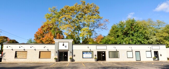
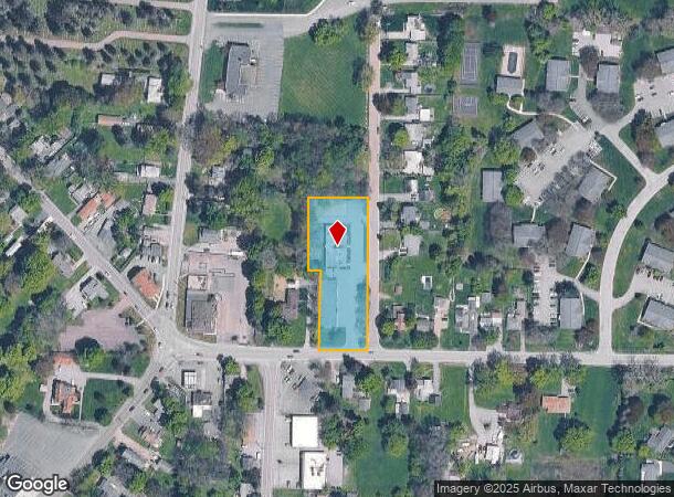
5020 Armor Duells Rd
146089-183-080-0004-006-000
Holland Land Companys Survey
Stripcommercialcenter
Erie
X
New York
36029C0481H
6.000
2025
1.30 AC
2024
South
013501
Buffalo/Niagara Falls
5,040 SF
Buffalo-Cheektowaga-Niagara Falls, NY
DEMOGRAPHICS near 5020 Armor Duells Rd
1 Mile
3 Mile
5 Mile
2024 Total Population
3,724
39,641
89,482
2029 Population
3,751
39,858
89,629
Pop Growth 2024-2029
+ 0.73%
+ 0.55%
+ 0.16%
Average Age
45
44
44
2024 Total Households
1,489
16,930
38,143
HH Growth 2024-2029
+ 0.60%
+ 0.46%
+ 0.07%
Median Household Inc
$86,886
$78,861
$76,740
Avg Household Size
2.40
2.20
2.30
2024 Avg HH Vehicles
2.00
2.00
2.00
Median Home Value
$266,634
$243,042
$236,818
Median Year Built
1978
1975
1972
Nearby Places
- Restaurants
- Banks
- Shops
- Fitness
- Groceries
PUBLIC TRANSPORTATION
AIRPORT
Buffalo Niagara International
DRIVE
WALK
Distance
Buffalo Niagara International
31 min
19.6 mi
Niagara Falls International
DRIVE
WALK
Distance
Niagara Falls International
50 min
32.4 mi
Freight Ports
Port of Toledo
DRIVE
WALK
Distance
Port of Toledo
350 min
295.4 mi
SALE & LEASE HISTORY
LISTING DATE
SALE/LEASE

May 06, 2019
For Lease
Aug 16, 2018
For Lease
Nearby Properties
Address
Land Use
TOTAL SIZE
Lot Size
Zoning
Address
Land Use
TOTAL SIZE
Lot Size
Zoning
49,500 SF
108.40 AC
R1
Address
Land Use
TOTAL SIZE
Lot Size
Zoning
14,835 SF
215.22 AC
C2
Address
Land Use
TOTAL SIZE
Lot Size
Zoning
22,754 SF
41.80 AC
Address
Land Use
TOTAL SIZE
Lot Size
Zoning
183,334 SF
50.90 AC
B2
Address
Land Use
TOTAL SIZE
Lot Size
Zoning
184,188 SF
110.75 AC
Address
Land Use
TOTAL SIZE
Lot Size
Zoning
77,270 SF
46.15 AC
C3
Address
Land Use
TOTAL SIZE
Lot Size
Zoning
11,383 SF
1,140.40 AC
A1
Address
Land Use
TOTAL SIZE
Lot Size
Zoning
118,358 SF
59.67 AC
Address
Land Use
TOTAL SIZE
Lot Size
Zoning
115,317 SF
17.87 AC
DR
Address
Land Use
TOTAL SIZE
Lot Size
Zoning
59,421 SF
75.40 AC
B1
Address
Land Use
TOTAL SIZE
Lot Size
Zoning
202,597 SF
24.22 AC
Address
Land Use
TOTAL SIZE
Lot Size
Zoning
97,709 SF
14.13 AC
R2
Address
Land Use
TOTAL SIZE
Lot Size
Zoning
91,618 SF
11.30 AC
Address
Land Use
TOTAL SIZE
Lot Size
Zoning
71,654 SF
24.35 AC
R2
Address
Land Use
TOTAL SIZE
Lot Size
Zoning
157,973 SF
16.50 AC
Address
Land Use
TOTAL SIZE
Lot Size
Zoning
10,486 SF
25.30 AC
R3
Address
Land Use
TOTAL SIZE
Lot Size
Zoning
221,896 SF
21.50 AC
Address
Land Use
TOTAL SIZE
Lot Size
Zoning
8,320 SF
22.10 AC
Address
Land Use
TOTAL SIZE
Lot Size
Zoning
137,276 SF
5.10 AC
Address
Land Use
TOTAL SIZE
Lot Size
Zoning
13,062 SF
26.07 AC
R4
Address
Land Use
TOTAL SIZE
Lot Size
Zoning
111,225 SF
10.52 AC
C2
Address
Land Use
TOTAL SIZE
Lot Size
Zoning
7,448 SF
24.51 AC
R3
Address
Land Use
TOTAL SIZE
Lot Size
Zoning
6,768 SF
13.89 AC
R3
Address
Land Use
TOTAL SIZE
Lot Size
Zoning
7,680 SF
14.20 AC
R3
Address
Land Use
TOTAL SIZE
Lot Size
Zoning
7,448 SF
12.16 AC
Address
Land Use
TOTAL SIZE
Lot Size
Zoning
74,669 SF
9.23 AC
Address
Land Use
TOTAL SIZE
Lot Size
Zoning
33,296 SF
12.50 AC
C1
Address
Land Use
TOTAL SIZE
Lot Size
Zoning
62,338 SF
10.27 AC
C1
Address
Land Use
TOTAL SIZE
Lot Size
Zoning
73,137 SF
R2
Address
Land Use
TOTAL SIZE
Lot Size
Zoning
89,371 SF
17.87 AC
R2
The World's #1 Commercial Real Estate Marketplace
Connect with us
© 2025 CoStar Group
The information above has been obtained from sources believed reliable. While we do not doubt its accuracy we have not verified it and make no guarantee, warranty or representation about it. It is your responsibility to independently confirm its accuracy and completeness. Any projections, opinions, assumptions, or estimates used are for example only and do not represent the current or future performance of the property. The value of this transaction to you depends on tax and other factors which should be evaluated by your tax, financial, and legal advisors. You and your advisors should conduct a careful, independent investigation of the property to determine to your satisfaction the suitability of the property for your needs.