Property Record
5020 Farwell St, Mcfarland, WI 53558

NEARBY LISTINGS FOR SALE OR LEASE
Property Detail
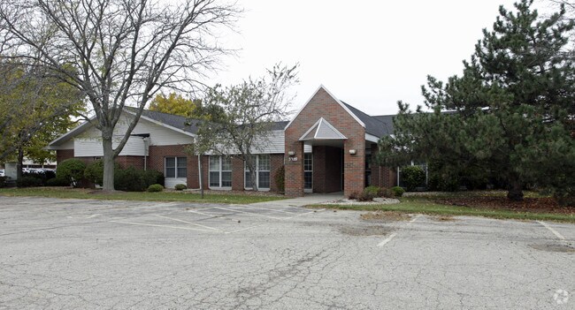
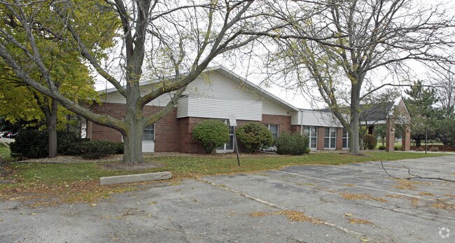
5020 Farwell St
Madison, WI
Farwell Street Plat
0610-031-4552-1
LOT 2 CSM 14352 CS98/98&102-9/28/2016 F/K/A LOTS 1, 2 & 3 CSM 14094 CS95/4&7-10/ 12/2015 F/K/A LOT 1 CSM 3246 CS12/356&357-7/20/79 F/K/A FARWELL STREET PLAT PRT LOT 9 & ALSO F/K/A LOTS 3 & 4 CSM 8478 CS46/159&160-2/10/97 F/K/A LOT 2 CSM 3246 CS12/356
Commercialnec
Dane
X
Wisconsin
55025C0443J
2,1,3
2024
0.95 AC
2024
Southeast Madison
010504
Milwaukee/Madison
DEMOGRAPHICS near 5020 Farwell St
1 Mile
3 Mile
5 Mile
2024 Total Population
8,182
16,385
50,735
2029 Population
8,494
17,019
52,601
Pop Growth 2024-2029
+ 3.81%
+ 3.87%
+ 3.68%
Average Age
40
40
41
2024 Total Households
3,331
6,530
21,614
HH Growth 2024-2029
+ 3.93%
+ 4.00%
+ 3.81%
Median Household Inc
$85,513
$97,180
$82,985
Avg Household Size
2.40
2.50
2.30
2024 Avg HH Vehicles
2.00
2.00
2.00
Median Home Value
$330,864
$338,606
$310,262
Median Year Built
1988
1991
1977
Nearby Places
Map Layers
Map Styles
 Street
 Aerial
- Restaurants
- Banks
- Shops
- Fitness
- Groceries
PUBLIC TRANSPORTATION
AIRPORT
Dane County Regional/Truax Field
DRIVE
WALK
Distance
Dane County Regional/Truax Field
18 min
11.1 mi
Freight Ports
Port Milwaukee
DRIVE
WALK
Distance
Port Milwaukee
96 min
81.7 mi
Nearby Properties
Address
Land Use
TOTAL SIZE
Lot Size
Zoning
Address
Land Use
TOTAL SIZE
Lot Size
Zoning
168,685 SF
14.05 AC
IL
Address
Land Use
TOTAL SIZE
Lot Size
Zoning
3.59 AC
Address
Land Use
TOTAL SIZE
Lot Size
Zoning
19.81 AC
Address
Land Use
TOTAL SIZE
Lot Size
Zoning
5.53 AC
Address
Land Use
TOTAL SIZE
Lot Size
Zoning
3.49 AC
Address
Land Use
TOTAL SIZE
Lot Size
Zoning
6,868 SF
18.35 AC
IL
Address
Land Use
TOTAL SIZE
Lot Size
Zoning
202,800 SF
13.05 AC
IL
Address
Land Use
TOTAL SIZE
Lot Size
Zoning
16.40 AC
IL
Address
Land Use
TOTAL SIZE
Lot Size
Zoning
10.45 AC
IL
Address
Land Use
TOTAL SIZE
Lot Size
Zoning
49,562 SF
4.42 AC
SE
Address
Land Use
TOTAL SIZE
Lot Size
Zoning
17,980 SF
6.25 AC
SR-V2
Address
Land Use
TOTAL SIZE
Lot Size
Zoning
9,030 SF
6.59 AC
SR-V2
Address
Land Use
TOTAL SIZE
Lot Size
Zoning
113,341 SF
11.66 AC
IL
Address
Land Use
TOTAL SIZE
Lot Size
Zoning
131,874 SF
8.98 AC
IL
Address
Land Use
TOTAL SIZE
Lot Size
Zoning
14.34 AC
IL
Address
Land Use
TOTAL SIZE
Lot Size
Zoning
11.76 AC
Address
Land Use
TOTAL SIZE
Lot Size
Zoning
7.98 AC
Address
Land Use
TOTAL SIZE
Lot Size
Zoning
221,410 SF
19.70 AC
IL
Address
Land Use
TOTAL SIZE
Lot Size
Zoning
7.24 AC
C-2
Address
Land Use
TOTAL SIZE
Lot Size
Zoning
2.07 AC
Address
Land Use
TOTAL SIZE
Lot Size
Zoning
10,440 SF
9.53 AC
IL
Address
Land Use
TOTAL SIZE
Lot Size
Zoning
Address
Land Use
TOTAL SIZE
Lot Size
Zoning
86,400 SF
6.53 AC
IL
Address
Land Use
TOTAL SIZE
Lot Size
Zoning
7.52 AC
IL
Address
Land Use
TOTAL SIZE
Lot Size
Zoning
3.30 AC
Address
Land Use
TOTAL SIZE
Lot Size
Zoning
122,500 SF
9.99 AC
IL
Address
Land Use
TOTAL SIZE
Lot Size
Zoning
64,151 SF
6.30 AC
IL
Address
Land Use
TOTAL SIZE
Lot Size
Zoning
233,145 SF
10.66 AC
IL
Address
Land Use
TOTAL SIZE
Lot Size
Zoning
50,000 SF
4.07 AC
IL
The World's #1 Commercial Real Estate Marketplace
Connect with us
© 2026 CoStar Group
The information above has been obtained from sources believed reliable. While we do not doubt its accuracy we have not verified it and make no guarantee, warranty or representation about it. It is your responsibility to independently confirm its accuracy and completeness. Any projections, opinions, assumptions, or estimates used are for example only and do not represent the current or future performance of the property. The value of this transaction to you depends on tax and other factors which should be evaluated by your tax, financial, and legal advisors. You and your advisors should conduct a careful, independent investigation of the property to determine to your satisfaction the suitability of the property for your needs.