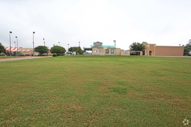
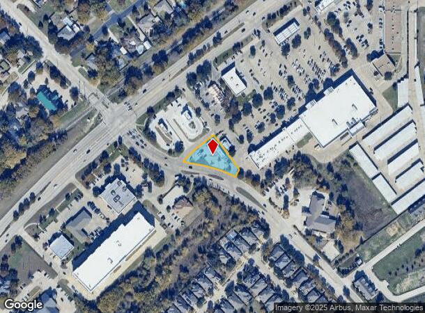
Property Record
5020 Highway 78, Sachse, TX 75048

NEARBY LISTINGS FOR SALE OR LEASE
Property Detail
5020 Highway 78
Dallas-Fort Worth-Arlington, TX
Oak Grove Plaza Amended
480040000A3AR0000
OAK GROVE PLAZA AMENDED BLK A LT 3AR ACS 0.513 INT201600239376 DD08262016 CO-DC 0040000A3AR00 2CK0040000A
Restaurantbuilding
Dallas
X
Texas
48113C0230K
3
2024
0.51 AC
2025
Garland
018154
Dallas/Ft Worth
1,875 SF
DEMOGRAPHICS near 5020 Highway 78
1 Mile
3 Mile
5 Mile
2024 Total Population
7,157
89,330
264,664
2029 Population
6,990
95,974
285,686
Pop Growth 2024-2029
(2.33%)
+ 7.44%
+ 7.94%
Average Age
40
39
38
2024 Total Households
2,467
30,387
87,726
HH Growth 2024-2029
(2.63%)
+ 7.05%
+ 7.66%
Median Household Inc
$114,107
$101,841
$90,614
Avg Household Size
2.90
2.90
3.00
2024 Avg HH Vehicles
3.00
2.00
2.00
Median Home Value
$296,629
$315,299
$290,507
Median Year Built
1998
1999
1994
Nearby Places
Map Layers
Map Styles
 Street
 Aerial
- Restaurants
- Banks
- Shops
- Fitness
- Groceries
PUBLIC TRANSPORTATION
AIRPORT
Dallas Love Field
DRIVE
WALK
Distance
Dallas Love Field
38 min
27.3 mi
Dallas-Fort Worth International
DRIVE
WALK
Distance
Dallas-Fort Worth International
43 min
35.4 mi
SALE & LEASE HISTORY
LISTING DATE
SALE/LEASE

Sep 30, 2016
For Lease
Sep 24, 2016
For Sale
Nearby Properties
Address
Land Use
TOTAL SIZE
Lot Size
Zoning
Address
Land Use
TOTAL SIZE
Lot Size
Zoning
768,061 SF
42.03 AC
Z02
Address
Land Use
TOTAL SIZE
Lot Size
Zoning
650,164 SF
66.57 AC
Z02
Address
Land Use
TOTAL SIZE
Lot Size
Zoning
548,300 SF
17.29 AC
Z239
Address
Land Use
TOTAL SIZE
Lot Size
Zoning
374,266 SF
19.42 AC
Z239
Address
Land Use
TOTAL SIZE
Lot Size
Zoning
350,553 SF
18.71 AC
MF-M
Address
Land Use
TOTAL SIZE
Lot Size
Zoning
353,347 SF
17 AC
Z02
Address
Land Use
TOTAL SIZE
Lot Size
Zoning
328,843 SF
11.70 AC
Z239
Address
Land Use
TOTAL SIZE
Lot Size
Zoning
433,745 SF
15.18 AC
Z02
Address
Land Use
TOTAL SIZE
Lot Size
Zoning
361,965 SF
11.12 AC
Z06
Address
Land Use
TOTAL SIZE
Lot Size
Zoning
231,434 SF
11.27 AC
Z06
Address
Land Use
TOTAL SIZE
Lot Size
Zoning
367,458 SF
13.42 AC
Address
Land Use
TOTAL SIZE
Lot Size
Zoning
310,382 SF
11.78 AC
Z148
Address
Land Use
TOTAL SIZE
Lot Size
Zoning
181,200 SF
15.11 AC
Address
Land Use
TOTAL SIZE
Lot Size
Zoning
320,801 SF
10.14 AC
Z236
Address
Land Use
TOTAL SIZE
Lot Size
Zoning
250,602 SF
4.99 AC
Z01
Address
Land Use
TOTAL SIZE
Lot Size
Zoning
423,253 SF
30.26 AC
Z239
Address
Land Use
TOTAL SIZE
Lot Size
Zoning
385,735 SF
13.13 AC
Address
Land Use
TOTAL SIZE
Lot Size
Zoning
261,164 SF
32.58 AC
Address
Land Use
TOTAL SIZE
Lot Size
Zoning
342,658 SF
4.94 AC
Z239
Address
Land Use
TOTAL SIZE
Lot Size
Zoning
366,600 SF
8.09 AC
Z06
Address
Land Use
TOTAL SIZE
Lot Size
Zoning
331,684 SF
9.80 AC
Z148
Address
Land Use
TOTAL SIZE
Lot Size
Zoning
403,206 SF
4 AC
Z239
Address
Land Use
TOTAL SIZE
Lot Size
Zoning
232,771 SF
15.69 AC
Z160
Address
Land Use
TOTAL SIZE
Lot Size
Zoning
245,596 SF
14.24 AC
Z160
Address
Land Use
TOTAL SIZE
Lot Size
Zoning
117,500 SF
16.71 AC
Z239
Address
Land Use
TOTAL SIZE
Lot Size
Zoning
65,595 SF
19.22 AC
Z239
Address
Land Use
TOTAL SIZE
Lot Size
Zoning
286,659 SF
9.94 AC
Z236
Address
Land Use
TOTAL SIZE
Lot Size
Zoning
259,280 SF
5.15 AC
Z01
Address
Land Use
TOTAL SIZE
Lot Size
Zoning
228,536 SF
10.54 AC
MF-M
Address
Land Use
TOTAL SIZE
Lot Size
Zoning
244,333 SF
14.52 AC
PD-MF2
The World's #1 Commercial Real Estate Marketplace
Connect with us
© 2025 CoStar Group
The information above has been obtained from sources believed reliable. While we do not doubt its accuracy we have not verified it and make no guarantee, warranty or representation about it. It is your responsibility to independently confirm its accuracy and completeness. Any projections, opinions, assumptions, or estimates used are for example only and do not represent the current or future performance of the property. The value of this transaction to you depends on tax and other factors which should be evaluated by your tax, financial, and legal advisors. You and your advisors should conduct a careful, independent investigation of the property to determine to your satisfaction the suitability of the property for your needs.