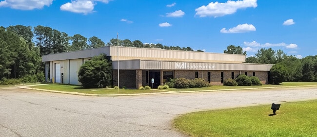
Property Record
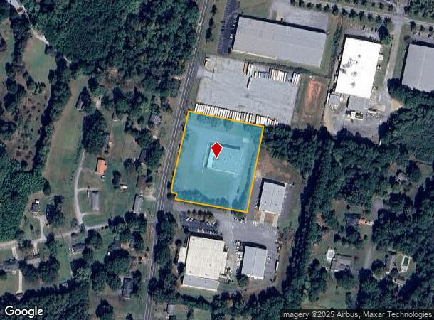
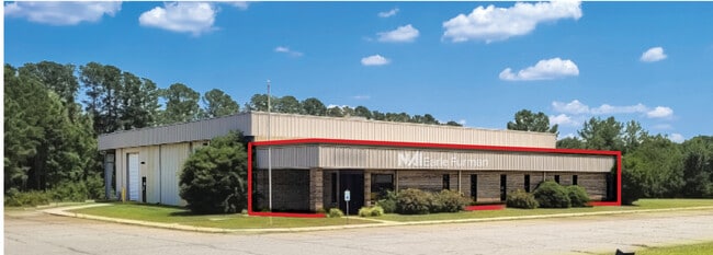
5020 N Blackstock Rd, Spartanburg, SC 29303
Current Lease Availabilities
NEARBY LISTINGS FOR SALE OR LEASE
Property Detail
5020 N Blackstock Rd
6-11-00-073.02
E SIDE N BLACKSTOCK RD & S OF OLD LOWE RD PB 118-399
Industrialgeneral
Spartanburg
X
South Carolina
45083C0231E
11,12
0
3.43 AC
2025
Upper Spartanburg Cty
021904
Greenville/Spartanburg
27,400 SF
Spartanburg, SC
DEMOGRAPHICS near 5020 N Blackstock Rd
1 Mile
3 Mile
5 Mile
2024 Total Population
1,270
21,049
79,705
2029 Population
1,472
23,702
90,377
Pop Growth 2024-2029
+ 15.91%
+ 12.60%
+ 13.39%
Average Age
40
37
38
2024 Total Households
511
7,867
29,954
HH Growth 2024-2029
+ 16.05%
+ 12.85%
+ 13.73%
Median Household Inc
$55,617
$49,959
$55,055
Avg Household Size
2.30
2.60
2.50
2024 Avg HH Vehicles
2.00
2.00
2.00
Median Home Value
$302,174
$177,599
$180,147
Median Year Built
1986
1987
1988
Nearby Places
- Restaurants
- Banks
- Shops
- Fitness
- Groceries
PUBLIC TRANSPORTATION
COMMUTER RAIL
Spartanburg Amtrak Station (Crescent - Amtrak)
DRIVE
WALK
Distance
Spartanburg Amtrak Station (Crescent - Amtrak)
15 min
6.8 mi
AIRPORT
Greenville Spartanburg International
DRIVE
WALK
Distance
Greenville Spartanburg International
24 min
15.3 mi
Freight Ports
North Charleston Terminal
DRIVE
WALK
Distance
North Charleston Terminal
221 min
197.1 mi
Nearby Properties
Address
Land Use
TOTAL SIZE
Lot Size
Zoning
Address
Land Use
TOTAL SIZE
Lot Size
Zoning
4,172 SF
15.98 AC
Address
Land Use
TOTAL SIZE
Lot Size
Zoning
175,000 SF
17.70 AC
Address
Land Use
TOTAL SIZE
Lot Size
Zoning
100,000 SF
8.29 AC
Address
Land Use
TOTAL SIZE
Lot Size
Zoning
239,095 SF
22.41 AC
Address
Land Use
TOTAL SIZE
Lot Size
Zoning
128,755 SF
4.47 AC
Address
Land Use
TOTAL SIZE
Lot Size
Zoning
11,830 SF
16.87 AC
Address
Land Use
TOTAL SIZE
Lot Size
Zoning
Address
Land Use
TOTAL SIZE
Lot Size
Zoning
64,092 SF
30.61 AC
Address
Land Use
TOTAL SIZE
Lot Size
Zoning
37.35 AC
Address
Land Use
TOTAL SIZE
Lot Size
Zoning
402,619 SF
58.63 AC
Address
Land Use
TOTAL SIZE
Lot Size
Zoning
23,884 SF
3.90 AC
Address
Land Use
TOTAL SIZE
Lot Size
Zoning
1,475 SF
41.85 AC
Address
Land Use
TOTAL SIZE
Lot Size
Zoning
1,092 SF
67.55 AC
Address
Land Use
TOTAL SIZE
Lot Size
Zoning
1,221,473 SF
36.50 AC
Address
Land Use
TOTAL SIZE
Lot Size
Zoning
341,895 SF
31.62 AC
Address
Land Use
TOTAL SIZE
Lot Size
Zoning
33,550 SF
3.77 AC
Address
Land Use
TOTAL SIZE
Lot Size
Zoning
101,622 SF
19.63 AC
Address
Land Use
TOTAL SIZE
Lot Size
Zoning
41,694 SF
4.01 AC
Address
Land Use
TOTAL SIZE
Lot Size
Zoning
5,888 SF
17.04 AC
Address
Land Use
TOTAL SIZE
Lot Size
Zoning
39.65 AC
Address
Land Use
TOTAL SIZE
Lot Size
Zoning
2,831 SF
10.07 AC
Address
Land Use
TOTAL SIZE
Lot Size
Zoning
69,836 SF
7.56 AC
Address
Land Use
TOTAL SIZE
Lot Size
Zoning
335,628 SF
17.93 AC
Address
Land Use
TOTAL SIZE
Lot Size
Zoning
157,500 SF
8.85 AC
Address
Land Use
TOTAL SIZE
Lot Size
Zoning
176,072 SF
13.72 AC
Address
Land Use
TOTAL SIZE
Lot Size
Zoning
201,900 SF
39.10 AC
Address
Land Use
TOTAL SIZE
Lot Size
Zoning
37,754 SF
47 AC
Address
Land Use
TOTAL SIZE
Lot Size
Zoning
124,696 SF
7.75 AC
Address
Land Use
TOTAL SIZE
Lot Size
Zoning
7,000 SF
3 AC
Address
Land Use
TOTAL SIZE
Lot Size
Zoning
193,279 SF
10.79 AC
The World's #1 Commercial Real Estate Marketplace
Connect with us
© 2025 CoStar Group
The information above has been obtained from sources believed reliable. While we do not doubt its accuracy we have not verified it and make no guarantee, warranty or representation about it. It is your responsibility to independently confirm its accuracy and completeness. Any projections, opinions, assumptions, or estimates used are for example only and do not represent the current or future performance of the property. The value of this transaction to you depends on tax and other factors which should be evaluated by your tax, financial, and legal advisors. You and your advisors should conduct a careful, independent investigation of the property to determine to your satisfaction the suitability of the property for your needs.