Property Record
5021 W Loop 289, Lubbock, TX 79414
Property Detail
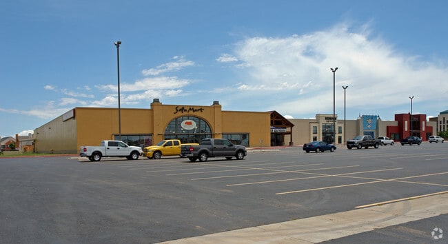
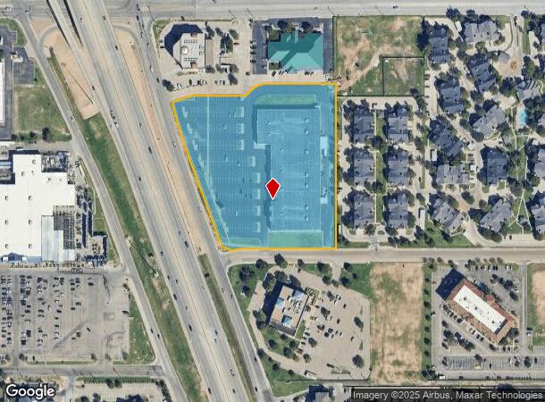
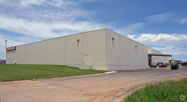
5021 W Loop 289
R151836
Furniture Row
Storebuilding
FURNITURE ROW TR A1
AE
Lubbock
48303C0295G
Texas
2024
6.84 AC
2025
Southwest Inner Loop
001708
Lubbock
86,273 SF
Lubbock, TX
NEARBY LISTINGS FOR SALE OR LEASE
DEMOGRAPHICS near 5021 W Loop 289
1 mile
3 mile
5 mile
2024 Total Population
10,643
95,848
216,867
2029 Population
11,309
101,627
230,410
Pop Growth 2024-2029
+ 6.26%
+ 6.03%
+ 6.24%
Average Age
34
37
36
2024 Total Households
5,096
40,869
88,747
HH Growth 2024-2029
+ 6.59%
+ 6.37%
+ 6.51%
Median Household Inc
$37,161
$59,659
$59,082
Avg Household Size
2.00
2.30
2.40
2024 Avg HH Vehicles
1.00
2.00
2.00
Median Home Value
$153,191
$190,307
$192,551
Median Year Built
1978
1982
1985
Nearby Places
Map Layers
Map Styles
 Street
 Aerial
Transit
 Traffic
 Biking
Places
Listings with unknown addresses are not visible on the map
- Restaurants
- Banks
- Shops
- Fitness
- Groceries
PUBLIC TRANSPORTATION
AIRPORT
Lubbock Preston Smith International
Drive
Walk
Distance
Lubbock Preston Smith International
33 min
16.7 mi
Freight Ports
Tulsa Port Of Catoosa
Drive
Walk
Distance
Tulsa Port Of Catoosa
512 min
476.2 mi
Nearby Properties
Address
Land Use
TOTAL SIZE
Lot Size
Zoning
Address
Land Use
TOTAL SIZE
Lot Size
Zoning
791,096 SF
63.76 AC
Address
Land Use
TOTAL SIZE
Lot Size
Zoning
391,942 SF
17.89 AC
Address
Land Use
TOTAL SIZE
Lot Size
Zoning
236,871 SF
6.77 AC
Address
Land Use
TOTAL SIZE
Lot Size
Zoning
276,552 SF
12.05 AC
Address
Land Use
TOTAL SIZE
Lot Size
Zoning
290,322 SF
11.96 AC
Address
Land Use
TOTAL SIZE
Lot Size
Zoning
106,894 SF
5.83 AC
Address
Land Use
TOTAL SIZE
Lot Size
Zoning
303,724 SF
17.32 AC
Address
Land Use
TOTAL SIZE
Lot Size
Zoning
64,800 SF
0.94 AC
Address
Land Use
TOTAL SIZE
Lot Size
Zoning
153,416 SF
3.14 AC
Address
Land Use
TOTAL SIZE
Lot Size
Zoning
289,796 SF
14.67 AC
Address
Land Use
TOTAL SIZE
Lot Size
Zoning
247,870 SF
11.48 AC
Address
Land Use
TOTAL SIZE
Lot Size
Zoning
186,763 SF
12 AC
Address
Land Use
TOTAL SIZE
Lot Size
Zoning
207,374 SF
15.51 AC
Address
Land Use
TOTAL SIZE
Lot Size
Zoning
108,363 SF
11.35 AC
Address
Land Use
TOTAL SIZE
Lot Size
Zoning
215,338 SF
26.49 AC
Address
Land Use
TOTAL SIZE
Lot Size
Zoning
169,556 SF
12 AC
Address
Land Use
TOTAL SIZE
Lot Size
Zoning
196,103 SF
12.33 AC
Address
Land Use
TOTAL SIZE
Lot Size
Zoning
246,478 SF
13 AC
Address
Land Use
TOTAL SIZE
Lot Size
Zoning
177,643 SF
10.13 AC
Address
Land Use
TOTAL SIZE
Lot Size
Zoning
156,495 SF
15.85 AC
Address
Land Use
TOTAL SIZE
Lot Size
Zoning
138,202 SF
11.33 AC
Address
Land Use
TOTAL SIZE
Lot Size
Zoning
24,540 SF
8.06 AC
Address
Land Use
TOTAL SIZE
Lot Size
Zoning
178,895 SF
7.85 AC
Address
Land Use
TOTAL SIZE
Lot Size
Zoning
156,038 SF
12.05 AC
Address
Land Use
TOTAL SIZE
Lot Size
Zoning
69.21 AC
Address
Land Use
TOTAL SIZE
Lot Size
Zoning
190,032 SF
11.89 AC
Address
Land Use
TOTAL SIZE
Lot Size
Zoning
103,560 SF
7.04 AC
Address
Land Use
TOTAL SIZE
Lot Size
Zoning
79,733 SF
3.14 AC
Address
Land Use
TOTAL SIZE
Lot Size
Zoning
205,567 SF
34.16 AC
Address
Land Use
TOTAL SIZE
Lot Size
Zoning
100,132 SF
8.42 AC
The World's #1 Commercial Real Estate Marketplace
Connect with us
© 2026 CoStar Group
The information above has been obtained from sources believed reliable. While we do not doubt its accuracy we have not verified it and make no guarantee, warranty or representation about it. It is your responsibility to independently confirm its accuracy and completeness. Any projections, opinions, assumptions, or estimates used are for example only and do not represent the current or future performance of the property. The value of this transaction to you depends on tax and other factors which should be evaluated by your tax, financial, and legal advisors. You and your advisors should conduct a careful, independent investigation of the property to determine to your satisfaction the suitability of the property for your needs.