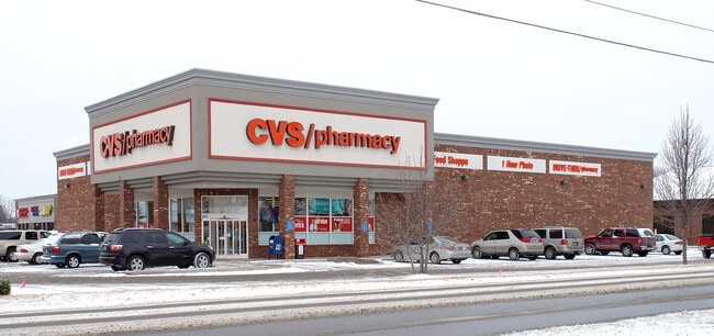
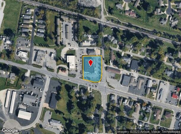
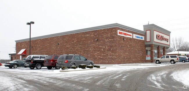
Property Record
5026 W Us Highway 52, New Palestine, IN 46163
NEARBY LISTINGS FOR SALE OR LEASE
Property Detail
5026 W Us Highway 52
30-10-30-100-003.001-013
NE NE 30-15-6 1.244 AC
Wholesaleoutletdiscountstore
Hancock
X
Indiana
18145C0010C
1.24 AC
2024
Hancock County
2024
Indianapolis
410802
Indianapolis-Carmel-Anderson, IN
10,941 SF
DEMOGRAPHICS near 5026 W Us Highway 52
1 Mile
3 Mile
5 Mile
2024 Total Population
4,331
11,568
28,606
2029 Population
4,787
12,697
30,613
Pop Growth 2024-2029
+ 10.53%
+ 9.76%
+ 7.02%
Average Age
42
42
41
2024 Total Households
1,664
4,330
10,647
HH Growth 2024-2029
+ 10.94%
+ 10.16%
+ 7.52%
Median Household Inc
$98,376
$98,313
$95,258
Avg Household Size
2.60
2.60
2.60
2024 Avg HH Vehicles
2.00
3.00
2.00
Median Home Value
$265,336
$265,771
$256,709
Median Year Built
1992
1990
1991
Nearby Places
Map Layers
Map Styles
 Street
 Aerial
- Restaurants
- Banks
- Shops
- Fitness
- Groceries
PUBLIC TRANSPORTATION
AIRPORT
Indianapolis International
DRIVE
WALK
Distance
Indianapolis International
46 min
26.4 mi
Freight Ports
Port of Toledo
DRIVE
WALK
Distance
Port of Toledo
274 min
221.1 mi
Nearby Properties
Address
Land Use
TOTAL SIZE
Lot Size
Zoning
Address
Land Use
TOTAL SIZE
Lot Size
Zoning
107,950 SF
10.93 AC
Address
Land Use
TOTAL SIZE
Lot Size
Zoning
48,838 SF
15.09 AC
Address
Land Use
TOTAL SIZE
Lot Size
Zoning
16,282 SF
10.23 AC
Address
Land Use
TOTAL SIZE
Lot Size
Zoning
53,658 SF
12.24 AC
Address
Land Use
TOTAL SIZE
Lot Size
Zoning
21,778 SF
3.17 AC
Address
Land Use
TOTAL SIZE
Lot Size
Zoning
53,337 SF
10 AC
Address
Land Use
TOTAL SIZE
Lot Size
Zoning
3,168 SF
2.56 AC
Address
Land Use
TOTAL SIZE
Lot Size
Zoning
5,805 SF
2.54 AC
Address
Land Use
TOTAL SIZE
Lot Size
Zoning
3,806 SF
4.96 AC
Address
Land Use
TOTAL SIZE
Lot Size
Zoning
10,454 SF
8.69 AC
Address
Land Use
TOTAL SIZE
Lot Size
Zoning
9,900 SF
3.86 AC
Address
Land Use
TOTAL SIZE
Lot Size
Zoning
21,737 SF
6 AC
Address
Land Use
TOTAL SIZE
Lot Size
Zoning
4,956 SF
1.52 AC
Address
Land Use
TOTAL SIZE
Lot Size
Zoning
5,120 SF
2.79 AC
Address
Land Use
TOTAL SIZE
Lot Size
Zoning
13,000 SF
1.17 AC
Address
Land Use
TOTAL SIZE
Lot Size
Zoning
9,065 SF
1.59 AC
Address
Land Use
TOTAL SIZE
Lot Size
Zoning
Address
Land Use
TOTAL SIZE
Lot Size
Zoning
4,200 SF
5 AC
Address
Land Use
TOTAL SIZE
Lot Size
Zoning
7,200 SF
6.62 AC
Address
Land Use
TOTAL SIZE
Lot Size
Zoning
6,264 SF
161.88 AC
Address
Land Use
TOTAL SIZE
Lot Size
Zoning
6,852 SF
2 AC
Address
Land Use
TOTAL SIZE
Lot Size
Zoning
12,800 SF
5.52 AC
Address
Land Use
TOTAL SIZE
Lot Size
Zoning
1,025 SF
25.30 AC
Address
Land Use
TOTAL SIZE
Lot Size
Zoning
11,088 SF
1.23 AC
Address
Land Use
TOTAL SIZE
Lot Size
Zoning
7,834 SF
1.54 AC
Address
Land Use
TOTAL SIZE
Lot Size
Zoning
8,394 SF
1.26 AC
Address
Land Use
TOTAL SIZE
Lot Size
Zoning
5,280 SF
1.21 AC
Address
Land Use
TOTAL SIZE
Lot Size
Zoning
4,688 SF
1.70 AC
Address
Land Use
TOTAL SIZE
Lot Size
Zoning
5,491 SF
1.49 AC
The World's #1 Commercial Real Estate Marketplace
Connect with us
© 2025 CoStar Group
The information above has been obtained from sources believed reliable. While we do not doubt its accuracy we have not verified it and make no guarantee, warranty or representation about it. It is your responsibility to independently confirm its accuracy and completeness. Any projections, opinions, assumptions, or estimates used are for example only and do not represent the current or future performance of the property. The value of this transaction to you depends on tax and other factors which should be evaluated by your tax, financial, and legal advisors. You and your advisors should conduct a careful, independent investigation of the property to determine to your satisfaction the suitability of the property for your needs.