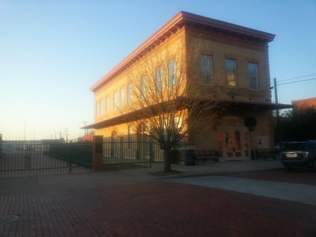
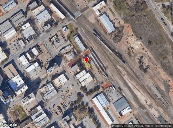
Property Record
503 8Th St, Wichita Falls, TX 76301
NEARBY LISTINGS FOR SALE OR LEASE
Property Detail
503 8Th St
Wichita Falls, TX
Original Town, Wf
159405
NW 30X90 FT LOTS 1&2 BLK 177 ORIGINAL TOWN, WF
Officebuilding
Wichita
X
Texas
48485C0340G
1,2
2024
0.06 AC
2025
Downtown Wichita Falls
010100
Other Market Areas
5,520 SF
DEMOGRAPHICS near 503 8Th St
1 Mile
3 Mile
5 Mile
2024 Total Population
5,599
37,060
80,164
2029 Population
5,912
38,378
82,270
Pop Growth 2024-2029
+ 5.59%
+ 3.56%
+ 2.63%
Average Age
38
38
37
2024 Total Households
2,241
15,019
30,998
HH Growth 2024-2029
+ 5.98%
+ 3.66%
+ 2.79%
Median Household Inc
$22,286
$38,645
$46,019
Avg Household Size
2.20
2.30
2.30
2024 Avg HH Vehicles
1.00
2.00
2.00
Median Home Value
$66,476
$78,950
$115,766
Median Year Built
1956
1957
1967
Nearby Places
Map Layers
Map Styles
 Street
 Aerial
- Restaurants
- Banks
- Shops
- Fitness
- Groceries
Nearby Properties
Address
Land Use
TOTAL SIZE
Lot Size
Zoning
Address
Land Use
TOTAL SIZE
Lot Size
Zoning
400,968 SF
123.30 AC
Address
Land Use
TOTAL SIZE
Lot Size
Zoning
164,255 SF
5.23 AC
Address
Land Use
TOTAL SIZE
Lot Size
Zoning
398,646 SF
7.51 AC
GC
Address
Land Use
TOTAL SIZE
Lot Size
Zoning
203,569 SF
27.74 AC
Address
Land Use
TOTAL SIZE
Lot Size
Zoning
245,152 SF
5.12 AC
GC
Address
Land Use
TOTAL SIZE
Lot Size
Zoning
233,084 SF
44.31 AC
SF2
Address
Land Use
TOTAL SIZE
Lot Size
Zoning
24,741 SF
37.75 AC
Address
Land Use
TOTAL SIZE
Lot Size
Zoning
266,509 SF
14.25 AC
SF2
Address
Land Use
TOTAL SIZE
Lot Size
Zoning
200,421 SF
18.57 AC
MFR
Address
Land Use
TOTAL SIZE
Lot Size
Zoning
167,247 SF
2.61 AC
CBD
Address
Land Use
TOTAL SIZE
Lot Size
Zoning
51,240 SF
3.46 AC
GC
Address
Land Use
TOTAL SIZE
Lot Size
Zoning
125,992 SF
4.22 AC
Address
Land Use
TOTAL SIZE
Lot Size
Zoning
80,294 SF
9.17 AC
Address
Land Use
TOTAL SIZE
Lot Size
Zoning
136,522 SF
4.11 AC
Address
Land Use
TOTAL SIZE
Lot Size
Zoning
82,217 SF
10.57 AC
SF2
Address
Land Use
TOTAL SIZE
Lot Size
Zoning
95,926 SF
1.21 AC
CBD
Address
Land Use
TOTAL SIZE
Lot Size
Zoning
179,865 SF
11.46 AC
Address
Land Use
TOTAL SIZE
Lot Size
Zoning
70,577 SF
8.22 AC
Address
Land Use
TOTAL SIZE
Lot Size
Zoning
125,809 SF
2.01 AC
GC
Address
Land Use
TOTAL SIZE
Lot Size
Zoning
109,536 SF
27.02 AC
Address
Land Use
TOTAL SIZE
Lot Size
Zoning
54,320 SF
4.64 AC
SF2
Address
Land Use
TOTAL SIZE
Lot Size
Zoning
108,972 SF
1.41 AC
CBD
Address
Land Use
TOTAL SIZE
Lot Size
Zoning
115,350 SF
4.86 AC
SF2
Address
Land Use
TOTAL SIZE
Lot Size
Zoning
34,268 SF
1.27 AC
Address
Land Use
TOTAL SIZE
Lot Size
Zoning
143,878 SF
20.85 AC
MFR
Address
Land Use
TOTAL SIZE
Lot Size
Zoning
99,097 SF
15.01 AC
GC
Address
Land Use
TOTAL SIZE
Lot Size
Zoning
64,637 SF
25.40 AC
Address
Land Use
TOTAL SIZE
Lot Size
Zoning
81,007 SF
23.24 AC
GC
Address
Land Use
TOTAL SIZE
Lot Size
Zoning
115,934 SF
2.63 AC
RDD
Address
Land Use
TOTAL SIZE
Lot Size
Zoning
138,450 SF
2.61 AC
CBD
The World's #1 Commercial Real Estate Marketplace
Connect with us
© 2025 CoStar Group
The information above has been obtained from sources believed reliable. While we do not doubt its accuracy we have not verified it and make no guarantee, warranty or representation about it. It is your responsibility to independently confirm its accuracy and completeness. Any projections, opinions, assumptions, or estimates used are for example only and do not represent the current or future performance of the property. The value of this transaction to you depends on tax and other factors which should be evaluated by your tax, financial, and legal advisors. You and your advisors should conduct a careful, independent investigation of the property to determine to your satisfaction the suitability of the property for your needs.