Property Record
503 Access Rd, Van Buren, AR 72956
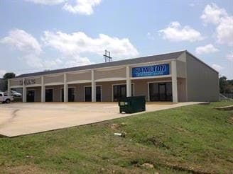

Property Detail
503 Access Rd
Fort Smith, AR-OK
PER DOC#2013004697 FILED 5/7/2013: TRACT 1 INTERSTATE 40 ACCESS ROAD TRACTS 1 THRU 3, BEING A PART OF THE NORTHEAST QUARTER O
700-03278-201-C
Crawford
Stripcommercialcenter
Arkansas
B and X Area of moderate flood hazard, usually the area between the limits of the 100-year and 500-year floods.
tk1
2025
0.81 AC
2025
Crawford County
020302
Fort Smith
6,000 SF
NEARBY LISTINGS FOR SALE OR LEASE
DEMOGRAPHICS near 503 Access Rd
1 mile
3 mile
5 mile
2025 Total Population
6,428
24,168
49,675
2030 Population
6,618
25,007
50,965
Pop Growth 2025-2030
+ 2.96%
+ 3.47%
+ 2.60%
Average Age
39
39
38
2025 Total Households
2,489
9,351
18,109
HH Growth 2025-2030
+ 2.97%
+ 3.53%
+ 2.68%
Median Household Inc
$57,559
$58,555
$53,332
Avg Household Size
2.50
2.50
2.60
2025 Avg HH Vehicles
2.00
2.00
2.00
Median Home Value
$187,640
$194,100
$164,571
Median Year Built
1992
1988
1981
Nearby Places
Map Layers
Map Styles
 Street
 Aerial
Layers
 Traffic
 Biking
Places
Listings with unknown addresses are not visible on the map
- Restaurants
- Banks
- Shops
- Fitness
- Groceries
PUBLIC TRANSPORTATION
AIRPORT
Fort Smith Regional
Drive
Walk
Distance
Fort Smith Regional
21 min
12.9 mi
Freight Ports
Tulsa Port of Inola
Drive
Walk
Distance
Tulsa Port of Inola
132 min
110.1 mi
Nearby Properties
Address
Land Use
TOTAL SIZE
Lot Size
Zoning
Address
Land Use
TOTAL SIZE
Lot Size
Zoning
856,730 SF
78.67 AC
Address
Land Use
TOTAL SIZE
Lot Size
Zoning
59,938 SF
48.92 AC
Address
Land Use
TOTAL SIZE
Lot Size
Zoning
194,508 SF
19.02 AC
Address
Land Use
TOTAL SIZE
Lot Size
Zoning
606,782 SF
92.40 AC
Address
Land Use
TOTAL SIZE
Lot Size
Zoning
154,830 SF
9.82 AC
Address
Land Use
TOTAL SIZE
Lot Size
Zoning
197,067 SF
17.34 AC
Address
Land Use
TOTAL SIZE
Lot Size
Zoning
581,085 SF
30.29 AC
Address
Land Use
TOTAL SIZE
Lot Size
Zoning
103,548 SF
4.78 AC
Address
Land Use
TOTAL SIZE
Lot Size
Zoning
138,756 SF
15.82 AC
Address
Land Use
TOTAL SIZE
Lot Size
Zoning
56,330 SF
12.75 AC
Address
Land Use
TOTAL SIZE
Lot Size
Zoning
69,745 SF
6.82 AC
Address
Land Use
TOTAL SIZE
Lot Size
Zoning
70,901 SF
3.21 AC
Address
Land Use
TOTAL SIZE
Lot Size
Zoning
102,973 SF
13.05 AC
Address
Land Use
TOTAL SIZE
Lot Size
Zoning
8,960 SF
1.12 AC
Address
Land Use
TOTAL SIZE
Lot Size
Zoning
233,541 SF
23.71 AC
Address
Land Use
TOTAL SIZE
Lot Size
Zoning
21,659 SF
3.11 AC
Address
Land Use
TOTAL SIZE
Lot Size
Zoning
52,341 SF
11.52 AC
Address
Land Use
TOTAL SIZE
Lot Size
Zoning
94,763 SF
11.29 AC
Address
Land Use
TOTAL SIZE
Lot Size
Zoning
11,189 SF
1.39 AC
Address
Land Use
TOTAL SIZE
Lot Size
Zoning
96,327 SF
6.06 AC
Address
Land Use
TOTAL SIZE
Lot Size
Zoning
51,884 SF
5 AC
Address
Land Use
TOTAL SIZE
Lot Size
Zoning
37,164 SF
15.82 AC
Address
Land Use
TOTAL SIZE
Lot Size
Zoning
37,247 SF
11.32 AC
Address
Land Use
TOTAL SIZE
Lot Size
Zoning
37,597 SF
3.20 AC
Address
Land Use
TOTAL SIZE
Lot Size
Zoning
186,250 SF
15.30 AC
Address
Land Use
TOTAL SIZE
Lot Size
Zoning
47,816 SF
1.60 AC
Address
Land Use
TOTAL SIZE
Lot Size
Zoning
27,404 SF
2.13 AC
Address
Land Use
TOTAL SIZE
Lot Size
Zoning
4,428 SF
45 AC
Address
Land Use
TOTAL SIZE
Lot Size
Zoning
30,335 SF
3.21 AC
Address
Land Use
TOTAL SIZE
Lot Size
Zoning
13,018 SF
8 AC
The World's #1 Commercial Real Estate Marketplace
Connect with us
© 2026 CoStar Group
The information above has been obtained from sources believed reliable. While we do not doubt its accuracy we have not verified it and make no guarantee, warranty or representation about it. It is your responsibility to independently confirm its accuracy and completeness. Any projections, opinions, assumptions, or estimates used are for example only and do not represent the current or future performance of the property. The value of this transaction to you depends on tax and other factors which should be evaluated by your tax, financial, and legal advisors. You and your advisors should conduct a careful, independent investigation of the property to determine to your satisfaction the suitability of the property for your needs.