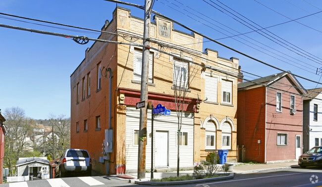
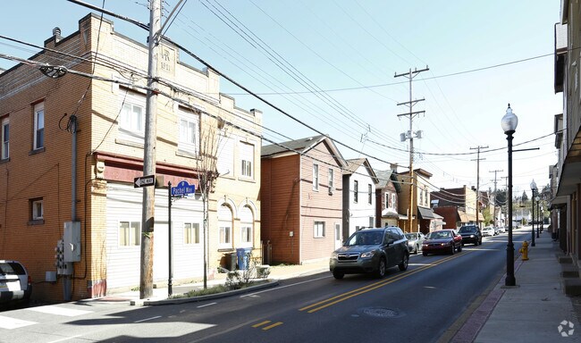
Property Record
503 Carothers Ave, Carnegie, PA 15106

Save to a Folder
{{folder.Name}}
{{folder.ListingIds.length}} Properties
{{folder.ListingIds.length}} Property
Create a New Folder
Property Detail
503 Carothers Ave
Pittsburgh, PA
CUBBAGE ADDN PLAN PT 33 ALL 34 LOT 39.16X106.58X36 .04 RR IN ALL CAROTHERS AVE 2 STY BRK V HSE 503-505
0102-G-00108-0000-00
Allegheny
Apartment
Pennsylvania
B and X Area of moderate flood hazard, usually the area between the limits of the 100-year and 500-year floods.
108
2026
0.09 AC
2026
Scott Township
470600
Pittsburgh
NEARBY LISTINGS FOR SALE OR LEASE
DEMOGRAPHICS near 503 Carothers Ave
1 mile
3 mile
5 mile
2025 Total Population
13,649
79,439
205,494
2030 Population
13,409
77,622
201,954
Pop Growth 2025-2030
(1.76%)
(2.29%)
(1.72%)
Average Age
43
44
43
2025 Total Households
6,569
36,039
91,822
HH Growth 2025-2030
(1.83%)
(2.37%)
(1.78%)
Median Household Inc
$71,714
$90,326
$85,818
Avg Household Size
2.00
2.10
2.20
2025 Avg HH Vehicles
1.00
2.00
2.00
Median Home Value
$190,465
$256,782
$244,038
Median Year Built
1953
1955
1955
Nearby Places
Map Layers
Map Styles
 Street
 Aerial
Layers
 Traffic
 Biking
Places
Listings with unknown addresses are not visible on the map
- Restaurants
- Banks
- Shops
- Fitness
- Groceries
PUBLIC TRANSPORTATION
COMMUTER RAIL
Drive
Walk
Distance
14 min
7.3 mi
AIRPORT
Pittsburgh International
Drive
Walk
Distance
Pittsburgh International
25 min
13.5 mi
Nearby Properties
Address
Land Use
TOTAL SIZE
Lot Size
Zoning
Address
Land Use
TOTAL SIZE
Lot Size
Zoning
Address
Land Use
TOTAL SIZE
Lot Size
Zoning
62.76 AC
Address
Land Use
TOTAL SIZE
Lot Size
Zoning
15.88 AC
Address
Land Use
TOTAL SIZE
Lot Size
Zoning
28.59 AC
Address
Land Use
TOTAL SIZE
Lot Size
Zoning
14.32 AC
Address
Land Use
TOTAL SIZE
Lot Size
Zoning
21.38 AC
Address
Land Use
TOTAL SIZE
Lot Size
Zoning
Address
Land Use
TOTAL SIZE
Lot Size
Zoning
12.68 AC
Address
Land Use
TOTAL SIZE
Lot Size
Zoning
17.50 AC
Address
Land Use
TOTAL SIZE
Lot Size
Zoning
Address
Land Use
TOTAL SIZE
Lot Size
Zoning
Address
Land Use
TOTAL SIZE
Lot Size
Zoning
36.95 AC
Address
Land Use
TOTAL SIZE
Lot Size
Zoning
17.04 AC
Address
Land Use
TOTAL SIZE
Lot Size
Zoning
15.26 AC
Address
Land Use
TOTAL SIZE
Lot Size
Zoning
37.96 AC
Address
Land Use
TOTAL SIZE
Lot Size
Zoning
16.70 AC
Address
Land Use
TOTAL SIZE
Lot Size
Zoning
1,272 SF
40.99 AC
Address
Land Use
TOTAL SIZE
Lot Size
Zoning
Address
Land Use
TOTAL SIZE
Lot Size
Zoning
Address
Land Use
TOTAL SIZE
Lot Size
Zoning
Address
Land Use
TOTAL SIZE
Lot Size
Zoning
20.31 AC
Address
Land Use
TOTAL SIZE
Lot Size
Zoning
8.62 AC
Address
Land Use
TOTAL SIZE
Lot Size
Zoning
12.34 AC
Address
Land Use
TOTAL SIZE
Lot Size
Zoning
Address
Land Use
TOTAL SIZE
Lot Size
Zoning
13.32 AC
Address
Land Use
TOTAL SIZE
Lot Size
Zoning
14.95 AC
Address
Land Use
TOTAL SIZE
Lot Size
Zoning
Address
Land Use
TOTAL SIZE
Lot Size
Zoning
Address
Land Use
TOTAL SIZE
Lot Size
Zoning
1.80 AC
Address
Land Use
TOTAL SIZE
Lot Size
Zoning
16.01 AC
The World's #1 Commercial Real Estate Marketplace
Connect with us
© 2026 CoStar Group
The information above has been obtained from sources believed reliable. While we do not doubt its accuracy we have not verified it and make no guarantee, warranty or representation about it. It is your responsibility to independently confirm its accuracy and completeness. Any projections, opinions, assumptions, or estimates used are for example only and do not represent the current or future performance of the property. The value of this transaction to you depends on tax and other factors which should be evaluated by your tax, financial, and legal advisors. You and your advisors should conduct a careful, independent investigation of the property to determine to your satisfaction the suitability of the property for your needs.