No Photo
Property Record
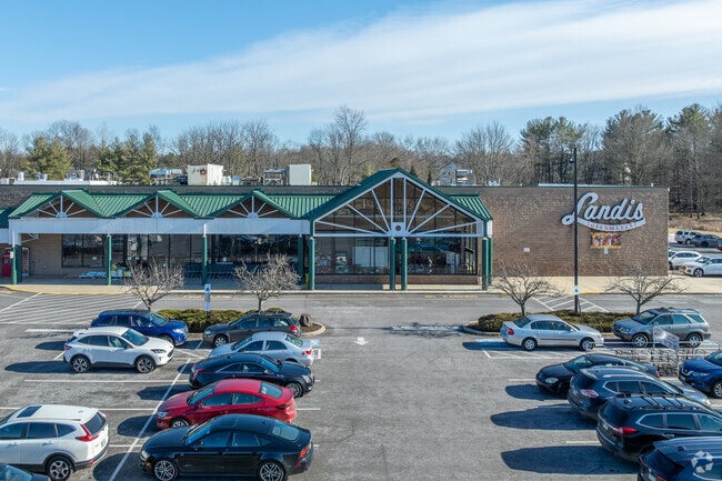
503 Constitution Ave, Perkasie, PA 18944


Property Detail
503 Constitution Ave
33-009-001
22.184AC ES CONSTITUTION 836 S OF SPRUCE ST 1140 ON CONSTITUTION AVE
Regionalshoppingcenterormallwithanchorstore
BUCKS
I2
Pennsylvania
AE The base floodplain where base flood elevations are provided. AE Zones are now used on new format FIRMs instead of A1-A30 Zones.
22.18 AC
2024
Upper Bucks County
2025
Philadelphia
102402
Philadelphia-Camden-Wilmington, PA-NJ-DE-MD
92,018 SF
NEARBY LISTINGS FOR SALE OR LEASE
DEMOGRAPHICS near 503 Constitution Ave
1 mile
3 mile
5 mile
2025 Total Population
11,992
33,842
71,217
2030 Population
12,083
34,050
71,960
Pop Growth 2025-2030
+ 0.76%
+ 0.61%
+ 1.04%
Average Age
41
42
43
2025 Total Households
4,697
13,049
27,357
HH Growth 2025-2030
+ 0.75%
+ 0.58%
+ 1.02%
Median Household Inc
$102,521
$109,388
$105,869
Avg Household Size
2.50
2.50
2.60
2025 Avg HH Vehicles
2.00
2.00
2.00
Median Home Value
$374,462
$401,872
$408,719
Median Year Built
1973
1979
1976
Nearby Places
Map Layers
Map Styles
 Street
 Aerial
Layers
 Traffic
 Biking
Places
Listings with unknown addresses are not visible on the map
- Restaurants
- Banks
- Shops
- Fitness
- Groceries
PUBLIC TRANSPORTATION
COMMUTER RAIL
Link Belt (R5 - Southeastern Pennsylvania Transportation Authority Regional Rail (SEPTA Regional Rail))
Drive
Walk
Distance
Link Belt (R5 - Southeastern Pennsylvania Transportation Authority Regional Rail (SEPTA Regional Rail))
14 min
8.1 mi
Chalfont (R5 - Southeastern Pennsylvania Transportation Authority Regional Rail (SEPTA Regional Rail))
Drive
Walk
Distance
Chalfont (R5 - Southeastern Pennsylvania Transportation Authority Regional Rail (SEPTA Regional Rail))
16 min
8.4 mi
AIRPORT
Lehigh Valley International
Drive
Walk
Distance
Lehigh Valley International
45 min
26.2 mi
Trenton Mercer
Drive
Walk
Distance
Trenton Mercer
59 min
33.6 mi
Freight Ports
Port of Philadelphia
Drive
Walk
Distance
Port of Philadelphia
54 min
32.3 mi
SALE & LEASE HISTORY
LISTING DATE
SALE/LEASE

Sep 25, 2016
For Lease
Jun 20, 2018
For Lease
Nearby Properties
Address
Land Use
TOTAL SIZE
Lot Size
Zoning
Address
Land Use
TOTAL SIZE
Lot Size
Zoning
412,306 SF
40.91 AC
I
Address
Land Use
TOTAL SIZE
Lot Size
Zoning
98,397 SF
8.23 AC
LI
Address
Land Use
TOTAL SIZE
Lot Size
Zoning
125,845 SF
11.85 AC
LI
Address
Land Use
TOTAL SIZE
Lot Size
Zoning
27,623 SF
4.44 AC
A
Address
Land Use
TOTAL SIZE
Lot Size
Zoning
80,544 SF
5.30 AC
LI
Address
Land Use
TOTAL SIZE
Lot Size
Zoning
256,512 SF
21.31 AC
CR
Address
Land Use
TOTAL SIZE
Lot Size
Zoning
205,462 SF
34.20 AC
52PI
Address
Land Use
TOTAL SIZE
Lot Size
Zoning
22,910 SF
7.23 AC
PMR
Address
Land Use
TOTAL SIZE
Lot Size
Zoning
1,261,187 SF
13.86 AC
CR
Address
Land Use
TOTAL SIZE
Lot Size
Zoning
63,069 SF
9.37 AC
C
Address
Land Use
TOTAL SIZE
Lot Size
Zoning
29,166 SF
2.18 AC
LI
Address
Land Use
TOTAL SIZE
Lot Size
Zoning
27,500 SF
2.37 AC
LI
Address
Land Use
TOTAL SIZE
Lot Size
Zoning
59,996 SF
17.61 AC
PC-1
Address
Land Use
TOTAL SIZE
Lot Size
Zoning
24,612 SF
2.34 AC
LI
Address
Land Use
TOTAL SIZE
Lot Size
Zoning
213,419 SF
33.19 AC
PI
Address
Land Use
TOTAL SIZE
Lot Size
Zoning
131,218 SF
14.23 AC
PRD
Address
Land Use
TOTAL SIZE
Lot Size
Zoning
137,040 SF
18.95 AC
LI
Address
Land Use
TOTAL SIZE
Lot Size
Zoning
63,433 SF
8.20 AC
CO
Address
Land Use
TOTAL SIZE
Lot Size
Zoning
13,250 SF
2.41 AC
LI
Address
Land Use
TOTAL SIZE
Lot Size
Zoning
66,214 SF
22.92 AC
PC
Address
Land Use
TOTAL SIZE
Lot Size
Zoning
18,780 SF
2.45 AC
LI
Address
Land Use
TOTAL SIZE
Lot Size
Zoning
68,463 SF
10.86 AC
IS
Address
Land Use
TOTAL SIZE
Lot Size
Zoning
34,630 SF
5 AC
PMR
Address
Land Use
TOTAL SIZE
Lot Size
Zoning
7.61 AC
CR
Address
Land Use
TOTAL SIZE
Lot Size
Zoning
37,444 SF
96.24 AC
PI
Address
Land Use
TOTAL SIZE
Lot Size
Zoning
94,897 SF
14.52 AC
PC-1
Address
Land Use
TOTAL SIZE
Lot Size
Zoning
105,840 SF
2.42 AC
R1B
Address
Land Use
TOTAL SIZE
Lot Size
Zoning
101,920 SF
21.05 AC
R1B
Address
Land Use
TOTAL SIZE
Lot Size
Zoning
98,213 SF
8.24 AC
LI
The World's #1 Commercial Real Estate Marketplace
Connect with us
© 2026 CoStar Group
The information above has been obtained from sources believed reliable. While we do not doubt its accuracy we have not verified it and make no guarantee, warranty or representation about it. It is your responsibility to independently confirm its accuracy and completeness. Any projections, opinions, assumptions, or estimates used are for example only and do not represent the current or future performance of the property. The value of this transaction to you depends on tax and other factors which should be evaluated by your tax, financial, and legal advisors. You and your advisors should conduct a careful, independent investigation of the property to determine to your satisfaction the suitability of the property for your needs.