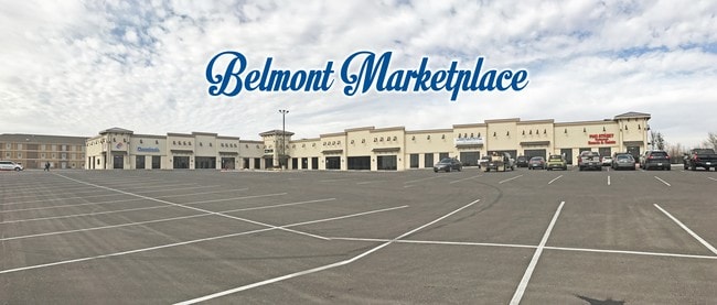
Property Record
503 E Interstate 20, Midland, TX 79701

Property Detail
503 E Interstate 20
Midland, TX
ACRES: 3.326 BLK: 062 LOT: 06A ADDN: BELMONT SEC 23
R000209-889
Midland
Parkinglot
Texas
2025
6a
2025
3.33 AC
001400
Midland & Odessa
2,300 SF
Other Market Areas
NEARBY LISTINGS FOR SALE OR LEASE
DEMOGRAPHICS near 503 E Interstate 20
1 mile
3 mile
5 mile
2025 Total Population
6,944
37,849
102,240
2030 Population
7,687
41,697
112,323
Pop Growth 2025-2030
+ 10.70%
+ 10.17%
+ 9.86%
Average Age
32
35
35
2025 Total Households
2,222
12,806
36,097
HH Growth 2025-2030
+ 11.84%
+ 11.35%
+ 11.08%
Median Household Inc
$44,339
$66,988
$81,648
Avg Household Size
2.90
2.80
2.70
2025 Avg HH Vehicles
2.00
2.00
2.00
Median Home Value
$176,823
$215,368
$256,599
Median Year Built
1990
1971
1975
Nearby Places
Map Layers
Map Styles
 Street
 Aerial
Transit
 Traffic
 Biking
Places
Listings with unknown addresses are not visible on the map
- Restaurants
- Banks
- Shops
- Fitness
- Groceries
PUBLIC TRANSPORTATION
AIRPORT
Midland International Air And Space Port
Drive
Walk
Distance
Midland International Air And Space Port
18 min
12.2 mi
Freight Ports
Calhoun Port
Drive
Walk
Distance
Calhoun Port
523 min
470.4 mi
SALE & LEASE HISTORY
LISTING DATE
SALE/LEASE

Sep 25, 2016
For Lease
Nearby Properties
Address
Land Use
TOTAL SIZE
Lot Size
Zoning
Address
Land Use
TOTAL SIZE
Lot Size
Zoning
15,052 SF
4.68 AC
C1
Address
Land Use
TOTAL SIZE
Lot Size
Zoning
245,203 SF
18.40 AC
Address
Land Use
TOTAL SIZE
Lot Size
Zoning
29,645 SF
2.07 AC
C1
Address
Land Use
TOTAL SIZE
Lot Size
Zoning
10,228 SF
15.98 AC
Address
Land Use
TOTAL SIZE
Lot Size
Zoning
8,004 SF
3.58 AC
C1
Address
Land Use
TOTAL SIZE
Lot Size
Zoning
133,056 SF
2.07 AC
C1
Address
Land Use
TOTAL SIZE
Lot Size
Zoning
7,200 SF
2.07 AC
C1
Address
Land Use
TOTAL SIZE
Lot Size
Zoning
46,512 SF
0.96 AC
C1
Address
Land Use
TOTAL SIZE
Lot Size
Zoning
96,390 SF
0.96 AC
C1
Address
Land Use
TOTAL SIZE
Lot Size
Zoning
7,008 SF
0.96 AC
C1
Address
Land Use
TOTAL SIZE
Lot Size
Zoning
41,790 SF
1.50 AC
C1
Address
Land Use
TOTAL SIZE
Lot Size
Zoning
12.91 AC
Address
Land Use
TOTAL SIZE
Lot Size
Zoning
800 SF
75.53 AC
Address
Land Use
TOTAL SIZE
Lot Size
Zoning
276 SF
0.48 AC
C1
Address
Land Use
TOTAL SIZE
Lot Size
Zoning
97,700 SF
10.79 AC
Address
Land Use
TOTAL SIZE
Lot Size
Zoning
26,390 SF
1.01 AC
C1
Address
Land Use
TOTAL SIZE
Lot Size
Zoning
21,609 SF
5.45 AC
O2
Address
Land Use
TOTAL SIZE
Lot Size
Zoning
86,922 SF
1.87 AC
PDMC
Address
Land Use
TOTAL SIZE
Lot Size
Zoning
6,510 SF
0.48 AC
C1
Address
Land Use
TOTAL SIZE
Lot Size
Zoning
218,900 SF
0.40 AC
C1
Address
Land Use
TOTAL SIZE
Lot Size
Zoning
1,116 SF
0.56 AC
C1
Address
Land Use
TOTAL SIZE
Lot Size
Zoning
9,650 SF
13 AC
MF1
Address
Land Use
TOTAL SIZE
Lot Size
Zoning
215,322 SF
19.80 AC
PDSC
Address
Land Use
TOTAL SIZE
Lot Size
Zoning
103,500 SF
0.20 AC
C1
Address
Land Use
TOTAL SIZE
Lot Size
Zoning
15,068 SF
2.77 AC
LR2
Address
Land Use
TOTAL SIZE
Lot Size
Zoning
720 SF
1.86 AC
Address
Land Use
TOTAL SIZE
Lot Size
Zoning
4,263 SF
8.01 AC
Address
Land Use
TOTAL SIZE
Lot Size
Zoning
17,022 SF
1.60 AC
Address
Land Use
TOTAL SIZE
Lot Size
Zoning
34,204 SF
53.45 AC
Address
Land Use
TOTAL SIZE
Lot Size
Zoning
13,440 SF
53.69 AC
The World's #1 Commercial Real Estate Marketplace
Connect with us
© 2026 CoStar Group
The information above has been obtained from sources believed reliable. While we do not doubt its accuracy we have not verified it and make no guarantee, warranty or representation about it. It is your responsibility to independently confirm its accuracy and completeness. Any projections, opinions, assumptions, or estimates used are for example only and do not represent the current or future performance of the property. The value of this transaction to you depends on tax and other factors which should be evaluated by your tax, financial, and legal advisors. You and your advisors should conduct a careful, independent investigation of the property to determine to your satisfaction the suitability of the property for your needs.