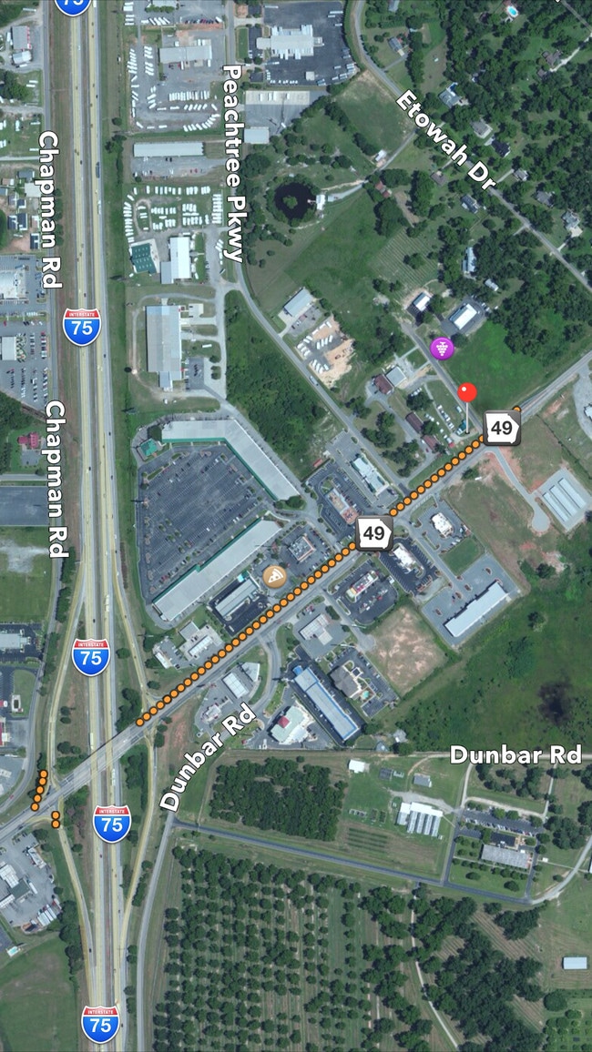
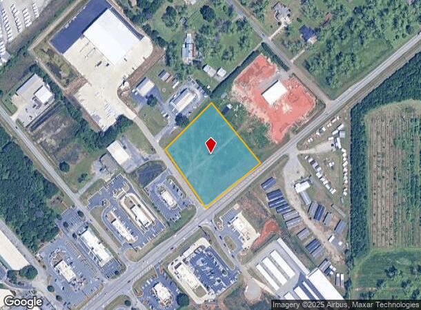
Property Record
503 Ga Highway 49 Pkwy N, Byron, GA 31008
NEARBY LISTINGS FOR SALE OR LEASE
Property Detail
503 Ga Highway 49 Pkwy N
Warner Robins, GA
Byron Commercial 404
055D-099
LL 30 LD 5TH \ 2.605 ACRES
Commercialacreage
Peach
X
Georgia
13021C0240G
30
2024
2.61 AC
2024
Perry/Warner Robins
040104
Other Market Areas
DEMOGRAPHICS near 503 Ga Highway 49 Pkwy N
1 Mile
3 Mile
5 Mile
2024 Total Population
846
14,607
39,898
2029 Population
889
15,659
42,422
Pop Growth 2024-2029
+ 5.08%
+ 7.20%
+ 6.33%
Average Age
45
40
40
2024 Total Households
366
5,616
15,726
HH Growth 2024-2029
+ 4.92%
+ 6.98%
+ 6.24%
Median Household Inc
$70,499
$70,293
$65,730
Avg Household Size
2.30
2.60
2.50
2024 Avg HH Vehicles
2.00
2.00
2.00
Median Home Value
$159,467
$147,181
$156,879
Median Year Built
2007
1994
1993
Nearby Places
Map Layers
Map Styles
 Street
 Aerial
- Restaurants
- Banks
- Shops
- Fitness
- Groceries
SALE & LEASE HISTORY
LISTING DATE
SALE/LEASE

Sep 24, 2016
For Sale
Nearby Properties
Address
Land Use
TOTAL SIZE
Lot Size
Zoning
Address
Land Use
TOTAL SIZE
Lot Size
Zoning
10,000 SF
1,163 AC
R-AG
Address
Land Use
TOTAL SIZE
Lot Size
Zoning
10,000 SF
43.93 AC
I-1
Address
Land Use
TOTAL SIZE
Lot Size
Zoning
80,825 SF
7.20 AC
I-1
Address
Land Use
TOTAL SIZE
Lot Size
Zoning
70,500 SF
18.47 AC
R1
Address
Land Use
TOTAL SIZE
Lot Size
Zoning
47,568 SF
1.51 AC
C-3
Address
Land Use
TOTAL SIZE
Lot Size
Zoning
42,056 SF
2.14 AC
C-3
Address
Land Use
TOTAL SIZE
Lot Size
Zoning
58,534 SF
7.82 AC
MULTI
Address
Land Use
TOTAL SIZE
Lot Size
Zoning
35,004 SF
1.45 AC
C-3
Address
Land Use
TOTAL SIZE
Lot Size
Zoning
17,388 SF
7.02 AC
MULTI
Address
Land Use
TOTAL SIZE
Lot Size
Zoning
24,400 SF
7 AC
MULTI
Address
Land Use
TOTAL SIZE
Lot Size
Zoning
57,888 SF
1.01 AC
I-1
Address
Land Use
TOTAL SIZE
Lot Size
Zoning
1,800 SF
33 AC
I-1
Address
Land Use
TOTAL SIZE
Lot Size
Zoning
26,131 SF
5.96 AC
C-1
Address
Land Use
TOTAL SIZE
Lot Size
Zoning
54,175 SF
12.72 AC
C-3
Address
Land Use
TOTAL SIZE
Lot Size
Zoning
5,110 SF
2.03 AC
C-3
Address
Land Use
TOTAL SIZE
Lot Size
Zoning
7,680 SF
1.31 AC
C2
Address
Land Use
TOTAL SIZE
Lot Size
Zoning
35,784 SF
6.23 AC
C-3
Address
Land Use
TOTAL SIZE
Lot Size
Zoning
4,294 SF
12 AC
R-AG
Address
Land Use
TOTAL SIZE
Lot Size
Zoning
12,026 SF
11.75 AC
R-1
Address
Land Use
TOTAL SIZE
Lot Size
Zoning
5,346 SF
2.13 AC
C-3
Address
Land Use
TOTAL SIZE
Lot Size
Zoning
11,083 SF
6.14 AC
C-2
Address
Land Use
TOTAL SIZE
Lot Size
Zoning
12,154 SF
15.06 AC
R-1
Address
Land Use
TOTAL SIZE
Lot Size
Zoning
22,688 SF
19.01 AC
R1
Address
Land Use
TOTAL SIZE
Lot Size
Zoning
7,232 SF
5.25 AC
C-1
Address
Land Use
TOTAL SIZE
Lot Size
Zoning
15,946 SF
2.26 AC
C-2
Address
Land Use
TOTAL SIZE
Lot Size
Zoning
3,000 SF
6.19 AC
C-3
Address
Land Use
TOTAL SIZE
Lot Size
Zoning
44,700 SF
6.20 AC
I-1
Address
Land Use
TOTAL SIZE
Lot Size
Zoning
3,500 SF
2.90 AC
C-1
Address
Land Use
TOTAL SIZE
Lot Size
Zoning
8,810 SF
5.48 AC
C-3
Address
Land Use
TOTAL SIZE
Lot Size
Zoning
12,780 SF
3.99 AC
R1
The World's #1 Commercial Real Estate Marketplace
Connect with us
© 2025 CoStar Group
The information above has been obtained from sources believed reliable. While we do not doubt its accuracy we have not verified it and make no guarantee, warranty or representation about it. It is your responsibility to independently confirm its accuracy and completeness. Any projections, opinions, assumptions, or estimates used are for example only and do not represent the current or future performance of the property. The value of this transaction to you depends on tax and other factors which should be evaluated by your tax, financial, and legal advisors. You and your advisors should conduct a careful, independent investigation of the property to determine to your satisfaction the suitability of the property for your needs.