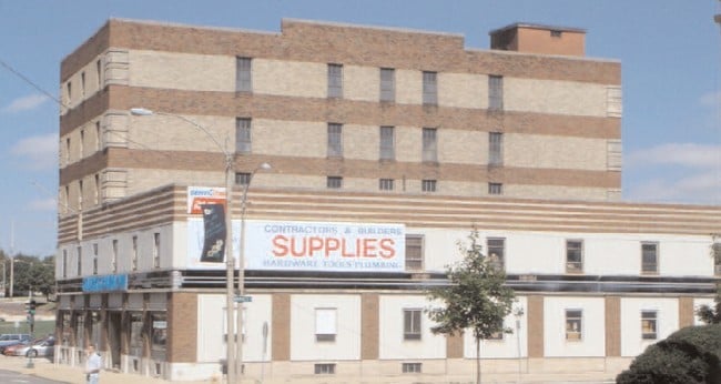
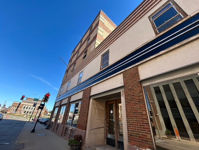
Property Record
501 N East St, Bloomington, IL 61701


Current Lease Availabilities
NEARBY LISTINGS FOR SALE OR LEASE
Property Detail
501 N East St
Bloomington, IL
Durley Addition
21-04-185-004
WALTON PLOW CO SUB LOT 6 BLK 18- DURLEY ADD & LOT 3 TO 8 BLK 2 KH FELLS 2ND ADD LOT 14 THRU 17
Commercialnec
Mclean
X
Illinois
17113C0501E
6
2022
0.20 AC
2024
Downtown Bloomington
001600
Other Market Areas
34,053 SF
DEMOGRAPHICS near 501 N East St
1 Mile
3 Mile
5 Mile
2024 Total Population
17,368
84,304
131,120
2029 Population
17,594
84,647
131,373
Pop Growth 2024-2029
+ 1.30%
+ 0.41%
+ 0.19%
Average Age
37
36
37
2024 Total Households
7,797
35,541
53,768
HH Growth 2024-2029
+ 1.35%
+ 0.39%
+ 0.21%
Median Household Inc
$40,620
$52,334
$65,930
Avg Household Size
1.90
2.10
2.20
2024 Avg HH Vehicles
1.00
2.00
2.00
Median Home Value
$110,042
$151,169
$181,860
Median Year Built
1947
1973
1981
Nearby Places
Map Layers
Map Styles
 Street
 Aerial
- Restaurants
- Banks
- Shops
- Fitness
- Groceries
PUBLIC TRANSPORTATION
COMMUTER RAIL
Bloomington-Normal (Lincoln Service - Amtrak, Lincoln Service Missouri River Runner - Amtrak, Texas Eagle - Amtrak)
DRIVE
WALK
Distance
Bloomington-Normal (Lincoln Service - Amtrak, Lincoln Service Missouri River Runner - Amtrak, Texas Eagle - Amtrak)
6 min
2.2 mi
AIRPORT
Central Il Regional/Bloomington-Normal
DRIVE
WALK
Distance
Central Il Regional/Bloomington-Normal
14 min
5.0 mi
Freight Ports
Port Milwaukee
DRIVE
WALK
Distance
Port Milwaukee
245 min
207.1 mi
Nearby Properties
Address
Land Use
TOTAL SIZE
Lot Size
Zoning
Address
Land Use
TOTAL SIZE
Lot Size
Zoning
131.22 AC
Address
Land Use
TOTAL SIZE
Lot Size
Zoning
1,867,780 SF
48.61 AC
Address
Land Use
TOTAL SIZE
Lot Size
Zoning
682,885 SF
44.48 AC
Address
Land Use
TOTAL SIZE
Lot Size
Zoning
562,852 SF
48.94 AC
Address
Land Use
TOTAL SIZE
Lot Size
Zoning
154,502 SF
1.25 AC
Address
Land Use
TOTAL SIZE
Lot Size
Zoning
493,944 SF
2.95 AC
R-3A
Address
Land Use
TOTAL SIZE
Lot Size
Zoning
445,676 SF
20.86 AC
Address
Land Use
TOTAL SIZE
Lot Size
Zoning
426,806 SF
20.93 AC
Address
Land Use
TOTAL SIZE
Lot Size
Zoning
127,569 SF
1.54 AC
Address
Land Use
TOTAL SIZE
Lot Size
Zoning
1,624,618 SF
54.32 AC
Address
Land Use
TOTAL SIZE
Lot Size
Zoning
333,419 SF
35.07 AC
Address
Land Use
TOTAL SIZE
Lot Size
Zoning
158,508 SF
3.13 AC
R1C
Address
Land Use
TOTAL SIZE
Lot Size
Zoning
351,208 SF
15.91 AC
Address
Land Use
TOTAL SIZE
Lot Size
Zoning
126,418 SF
1.06 AC
Address
Land Use
TOTAL SIZE
Lot Size
Zoning
123,016 SF
18.52 AC
C-2
Address
Land Use
TOTAL SIZE
Lot Size
Zoning
432,093 SF
15 AC
Address
Land Use
TOTAL SIZE
Lot Size
Zoning
10.13 AC
R2
Address
Land Use
TOTAL SIZE
Lot Size
Zoning
228,378 SF
7.99 AC
Address
Land Use
TOTAL SIZE
Lot Size
Zoning
136,382 SF
9.53 AC
Address
Land Use
TOTAL SIZE
Lot Size
Zoning
733,822 SF
18.01 AC
Address
Land Use
TOTAL SIZE
Lot Size
Zoning
422,234 SF
23.17 AC
Address
Land Use
TOTAL SIZE
Lot Size
Zoning
200,445 SF
8.33 AC
Address
Land Use
TOTAL SIZE
Lot Size
Zoning
275,860 SF
12.17 AC
Address
Land Use
TOTAL SIZE
Lot Size
Zoning
454,529 SF
19.25 AC
Address
Land Use
TOTAL SIZE
Lot Size
Zoning
122,112 SF
7.16 AC
Address
Land Use
TOTAL SIZE
Lot Size
Zoning
276,695 SF
12.68 AC
Address
Land Use
TOTAL SIZE
Lot Size
Zoning
388,851 SF
4.40 AC
Address
Land Use
TOTAL SIZE
Lot Size
Zoning
191,880 SF
3 AC
B-1
Address
Land Use
TOTAL SIZE
Lot Size
Zoning
2,907 SF
96.29 AC
The World's #1 Commercial Real Estate Marketplace
Connect with us
© 2026 CoStar Group
The information above has been obtained from sources believed reliable. While we do not doubt its accuracy we have not verified it and make no guarantee, warranty or representation about it. It is your responsibility to independently confirm its accuracy and completeness. Any projections, opinions, assumptions, or estimates used are for example only and do not represent the current or future performance of the property. The value of this transaction to you depends on tax and other factors which should be evaluated by your tax, financial, and legal advisors. You and your advisors should conduct a careful, independent investigation of the property to determine to your satisfaction the suitability of the property for your needs.