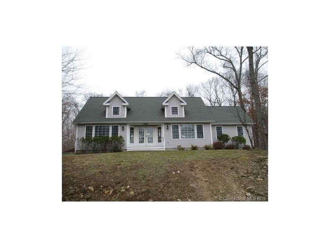
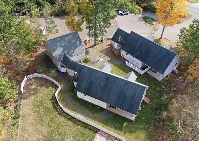
Property Record
503 Old Toll Rd, Madison, CT 06443

Property Detail
503 Old Toll Rd
Commercialofficeresidentialmixeduse
South Central Ct
RU-1
Connecticut
B and X Area of moderate flood hazard, usually the area between the limits of the 100-year and 500-year floods.
1.97 AC
2025
Guilford
2025
Westchester/So Connecticut
194202
New Haven, CT
1,235 SF
MADI-000143-000000-000020
NEARBY LISTINGS FOR SALE OR LEASE
-
-
View all Madison listings for lease on LoopNet.com
DEMOGRAPHICS near 503 Old Toll Rd
1 mile
3 mile
5 mile
2025 Total Population
1,384
8,025
26,912
2030 Population
1,392
8,098
27,254
Pop Growth 2025-2030
+ 0.58%
+ 0.91%
+ 1.27%
Average Age
43
44
45
2025 Total Households
497
2,854
9,944
HH Growth 2025-2030
+ 0.60%
+ 0.84%
+ 1.22%
Median Household Inc
$189,772
$183,076
$148,337
Avg Household Size
2.80
2.80
2.70
2025 Avg HH Vehicles
3.00
3.00
2.00
Median Home Value
$487,074
$527,226
$512,634
Median Year Built
1984
1980
1978
Nearby Places
Map Layers
Map Styles
 Street
 Aerial
Layers
 Traffic
 Biking
Places
Listings with unknown addresses are not visible on the map
- Restaurants
- Banks
- Shops
- Fitness
- Groceries
PUBLIC TRANSPORTATION
COMMUTER RAIL
Madison (Shore Line East - Shore Line East)
Drive
Walk
Distance
Madison (Shore Line East - Shore Line East)
11 min
6.4 mi
Drive
Walk
Distance
19 min
8.8 mi
AIRPORT
Tweed/New Haven
Drive
Walk
Distance
Tweed/New Haven
29 min
17.0 mi
SALE & LEASE HISTORY
LISTING DATE
SALE/LEASE

Sep 23, 2016
For Sale
Sep 11, 2019
For Lease
Dec 22, 2017
For Sale
Apr 10, 2017
For Sale
Nearby Properties
Address
Land Use
TOTAL SIZE
Lot Size
Zoning
Address
Land Use
TOTAL SIZE
Lot Size
Zoning
42,200 SF
53 AC
RU-1
Address
Land Use
TOTAL SIZE
Lot Size
Zoning
345 AC
R-2
Address
Land Use
TOTAL SIZE
Lot Size
Zoning
1,353 SF
132.69 AC
RU-1
Address
Land Use
TOTAL SIZE
Lot Size
Zoning
1,224 SF
599.16 AC
RU-1
Address
Land Use
TOTAL SIZE
Lot Size
Zoning
3,479 SF
255.50 AC
R-2
Address
Land Use
TOTAL SIZE
Lot Size
Zoning
32,640 SF
10.37 AC
R-S
Address
Land Use
TOTAL SIZE
Lot Size
Zoning
3,344 SF
21.31 AC
RU-1
Address
Land Use
TOTAL SIZE
Lot Size
Zoning
14,112 SF
9.25 AC
RU-1
Address
Land Use
TOTAL SIZE
Lot Size
Zoning
5,977 SF
2 AC
RU-1
Address
Land Use
TOTAL SIZE
Lot Size
Zoning
125.40 AC
R-2
Address
Land Use
TOTAL SIZE
Lot Size
Zoning
7,120 SF
0.38 AC
RU-1
Address
Land Use
TOTAL SIZE
Lot Size
Zoning
69.80 AC
RU-1
Address
Land Use
TOTAL SIZE
Lot Size
Zoning
77.06 AC
RU-1
Address
Land Use
TOTAL SIZE
Lot Size
Zoning
54.41 AC
RU-1
Address
Land Use
TOTAL SIZE
Lot Size
Zoning
49 AC
RU-1
Address
Land Use
TOTAL SIZE
Lot Size
Zoning
5.03 AC
R-2
Address
Land Use
TOTAL SIZE
Lot Size
Zoning
2,898 SF
42.16 AC
RU-1
Address
Land Use
TOTAL SIZE
Lot Size
Zoning
2,295.68 AC
RU-1
Address
Land Use
TOTAL SIZE
Lot Size
Zoning
47.13 AC
RU-1
Address
Land Use
TOTAL SIZE
Lot Size
Zoning
6,480 SF
4 AC
RU-1
Address
Land Use
TOTAL SIZE
Lot Size
Zoning
Address
Land Use
TOTAL SIZE
Lot Size
Zoning
1,596 SF
43.40 AC
R-2
Address
Land Use
TOTAL SIZE
Lot Size
Zoning
780 SF
6.60 AC
R-2
Address
Land Use
TOTAL SIZE
Lot Size
Zoning
2,590 SF
4.55 AC
RU-1
Address
Land Use
TOTAL SIZE
Lot Size
Zoning
4,696 SF
1.99 AC
RU-1
Address
Land Use
TOTAL SIZE
Lot Size
Zoning
33 AC
RU-1
Address
Land Use
TOTAL SIZE
Lot Size
Zoning
1,747 SF
3.84 AC
RU-1
Address
Land Use
TOTAL SIZE
Lot Size
Zoning
2,520 SF
2.65 AC
RU-1
Address
Land Use
TOTAL SIZE
Lot Size
Zoning
1,584 SF
1.30 AC
RU-1
Address
Land Use
TOTAL SIZE
Lot Size
Zoning
185 AC
R-2
The World's #1 Commercial Real Estate Marketplace
Connect with us
© 2026 CoStar Group
The information above has been obtained from sources believed reliable. While we do not doubt its accuracy we have not verified it and make no guarantee, warranty or representation about it. It is your responsibility to independently confirm its accuracy and completeness. Any projections, opinions, assumptions, or estimates used are for example only and do not represent the current or future performance of the property. The value of this transaction to you depends on tax and other factors which should be evaluated by your tax, financial, and legal advisors. You and your advisors should conduct a careful, independent investigation of the property to determine to your satisfaction the suitability of the property for your needs.