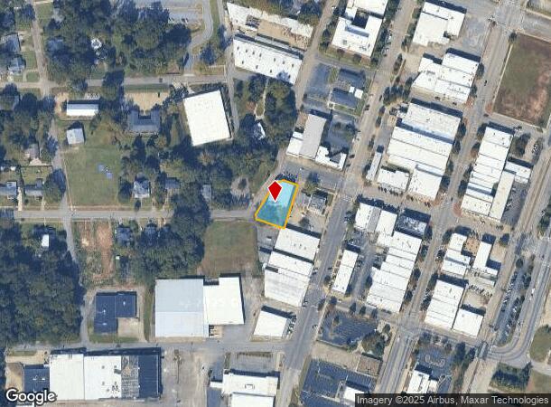
Property Record
503 W 8Th St, West Point, GA 31833


NEARBY LISTINGS FOR SALE OR LEASE
-
-
View all West Point listings for sale on LoopNet.com
Property Detail
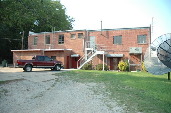
503 W 8Th St
094-3W-015-001
Country Cove
Apartment
503 W 8TH ST
AE
Troup
13285C0218F
Georgia
2024
0.35 AC
2025
Troup County
961000
Columbus GA
11,818 SF
LaGrange, GA
DEMOGRAPHICS near 503 W 8Th St
1 Mile
3 Mile
5 Mile
2024 Total Population
4,771
14,549
21,984
2029 Population
4,915
14,665
21,911
Pop Growth 2024-2029
+ 3.02%
+ 0.80%
(0.33%)
Average Age
40
41
41
2024 Total Households
1,810
5,781
8,857
HH Growth 2024-2029
+ 3.48%
+ 0.92%
(0.24%)
Median Household Inc
$46,783
$46,955
$47,433
Avg Household Size
2.50
2.40
2.40
2024 Avg HH Vehicles
2.00
2.00
2.00
Median Home Value
$133,158
$139,207
$129,254
Median Year Built
1975
1971
1974
Nearby Places
Map Layers
Map Styles
 Street
 Aerial
- Restaurants
- Banks
- Shops
- Fitness
- Groceries
PUBLIC TRANSPORTATION
AIRPORT
Columbus
DRIVE
WALK
Distance
Columbus
47 min
34.9 mi
Freight Ports
Port of Panama City
DRIVE
WALK
Distance
Port of Panama City
281 min
216.6 mi
SALE & LEASE HISTORY
LISTING DATE
SALE/LEASE

Mar 02, 2022
For Sale
Nearby Properties
Address
Land Use
TOTAL SIZE
Lot Size
Zoning
Address
Land Use
TOTAL SIZE
Lot Size
Zoning
39,034.56 AC
UNAVAILABL
Address
Land Use
TOTAL SIZE
Lot Size
Zoning
132,260 SF
4.03 AC
Address
Land Use
TOTAL SIZE
Lot Size
Zoning
17,098 SF
19.05 AC
17-SPLIT
Address
Land Use
TOTAL SIZE
Lot Size
Zoning
28,850 SF
6.63 AC
17-MXD-1
Address
Land Use
TOTAL SIZE
Lot Size
Zoning
6,800 SF
10 AC
17-I-1
Address
Land Use
TOTAL SIZE
Lot Size
Zoning
42,369 SF
1.49 AC
17-I-1
Address
Land Use
TOTAL SIZE
Lot Size
Zoning
523.41 AC
17-MXD-1
Address
Land Use
TOTAL SIZE
Lot Size
Zoning
31,290 SF
0.75 AC
17-CGN
Address
Land Use
TOTAL SIZE
Lot Size
Zoning
185.02 AC
17-R/P
Address
Land Use
TOTAL SIZE
Lot Size
Zoning
19,493 SF
15 AC
17-R-1
Address
Land Use
TOTAL SIZE
Lot Size
Zoning
106,133 SF
8.37 AC
17-I-1
Address
Land Use
TOTAL SIZE
Lot Size
Zoning
146,616 SF
9.10 AC
Address
Land Use
TOTAL SIZE
Lot Size
Zoning
7,326 SF
4.50 AC
17-I-1
Address
Land Use
TOTAL SIZE
Lot Size
Zoning
20,409 SF
2.46 AC
17-R-1
Address
Land Use
TOTAL SIZE
Lot Size
Zoning
36,225 SF
5.74 AC
17-I-1
Address
Land Use
TOTAL SIZE
Lot Size
Zoning
18,960 SF
0.36 AC
17-CBD
Address
Land Use
TOTAL SIZE
Lot Size
Zoning
34,584 SF
3.68 AC
17-I-1
Address
Land Use
TOTAL SIZE
Lot Size
Zoning
17,852 SF
1.26 AC
17-CBD
Address
Land Use
TOTAL SIZE
Lot Size
Zoning
2,145 SF
8.59 AC
17-MXD-1
Address
Land Use
TOTAL SIZE
Lot Size
Zoning
15,711 SF
0.71 AC
17-R-1
Address
Land Use
TOTAL SIZE
Lot Size
Zoning
57,000 SF
17.44 AC
17-I-1
Address
Land Use
TOTAL SIZE
Lot Size
Zoning
23,487 SF
2 AC
17-I-1
Address
Land Use
TOTAL SIZE
Lot Size
Zoning
8,032 SF
32.02 AC
Address
Land Use
TOTAL SIZE
Lot Size
Zoning
10,794 SF
1.35 AC
17-CBD
Address
Land Use
TOTAL SIZE
Lot Size
Zoning
10,752 SF
0.70 AC
17-CBD
Address
Land Use
TOTAL SIZE
Lot Size
Zoning
14,075 SF
0.41 AC
17-I-1
Address
Land Use
TOTAL SIZE
Lot Size
Zoning
166 AC
17-MXD-1
Address
Land Use
TOTAL SIZE
Lot Size
Zoning
7,200 SF
9.90 AC
17-R-1
Address
Land Use
TOTAL SIZE
Lot Size
Zoning
0.09 AC
RH2
Address
Land Use
TOTAL SIZE
Lot Size
Zoning
31,680 SF
0.28 AC
17-CBD
The World's #1 Commercial Real Estate Marketplace
Connect with us
© 2025 CoStar Group
The information above has been obtained from sources believed reliable. While we do not doubt its accuracy we have not verified it and make no guarantee, warranty or representation about it. It is your responsibility to independently confirm its accuracy and completeness. Any projections, opinions, assumptions, or estimates used are for example only and do not represent the current or future performance of the property. The value of this transaction to you depends on tax and other factors which should be evaluated by your tax, financial, and legal advisors. You and your advisors should conduct a careful, independent investigation of the property to determine to your satisfaction the suitability of the property for your needs.