Property Record
503 W Brannen Rd, Lakeland, FL 33813

Current Lease Availabilities
NEARBY LISTINGS FOR SALE OR LEASE
Property Detail
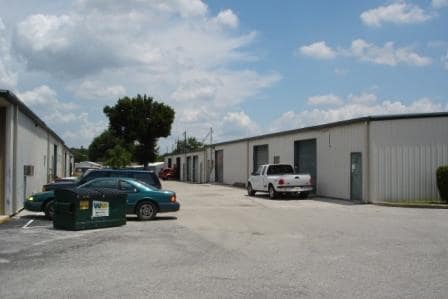
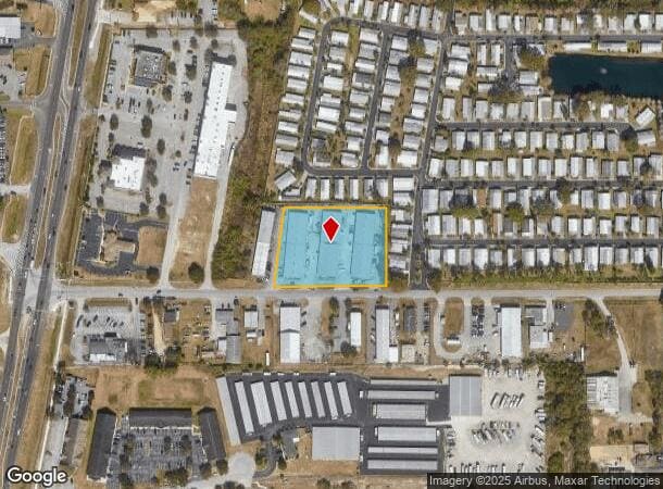
503 W Brannen Rd
23-29-13-000000-014130
Brannen Industrial Complex
Warehouse
BEG SW COR OF SW1/4 OF NE1/4 RUN N 400 FT E 239.71 FT FOR POB CONT E 446.26 FT N 310 FT W 391.5 FT S10-05-31W 314.5 FT TO POB LESS S 60 FT FOR BRANNEN RD R/W & LESS COMM AT SW COR OF SW1/4 OF NE1/4 RUN N 400 FT E 239.71 FT TO POB CONT E 80.54 FT RUN
X
Polk
12105C0480G
Florida
2024
1.96 AC
2025
Polk County
011836
Tampa/St Petersburg
35,880 SF
Lakeland-Winter Haven, FL
DEMOGRAPHICS near 503 W Brannen Rd
1 Mile
3 Mile
5 Mile
2024 Total Population
7,281
51,778
123,439
2029 Population
8,635
61,343
146,795
Pop Growth 2024-2029
+ 18.60%
+ 18.47%
+ 18.92%
Average Age
40
41
40
2024 Total Households
2,792
19,949
47,895
HH Growth 2024-2029
+ 18.59%
+ 18.39%
+ 18.89%
Median Household Inc
$67,918
$80,122
$71,556
Avg Household Size
2.60
2.60
2.50
2024 Avg HH Vehicles
2.00
2.00
2.00
Median Home Value
$280,999
$275,344
$247,402
Median Year Built
1985
1988
1986
Nearby Places
Map Layers
Map Styles
 Street
 Aerial
- Restaurants
- Banks
- Shops
- Fitness
- Groceries
PUBLIC TRANSPORTATION
COMMUTER RAIL
DRIVE
WALK
Distance
14 min
6.4 mi
AIRPORT
Tampa International
DRIVE
WALK
Distance
Tampa International
59 min
43.4 mi
Freight Ports
Port of Tampa Bay
DRIVE
WALK
Distance
Port of Tampa Bay
52 min
37.6 mi
Nearby Properties
Address
Land Use
TOTAL SIZE
Lot Size
Zoning
Address
Land Use
TOTAL SIZE
Lot Size
Zoning
292,243 SF
11.94 AC
PUD
Address
Land Use
TOTAL SIZE
Lot Size
Zoning
306,126 SF
25.03 AC
Address
Land Use
TOTAL SIZE
Lot Size
Zoning
336,260 SF
93.82 AC
RE1
Address
Land Use
TOTAL SIZE
Lot Size
Zoning
364,518 SF
23.38 AC
Address
Land Use
TOTAL SIZE
Lot Size
Zoning
363,147 SF
76.15 AC
Address
Land Use
TOTAL SIZE
Lot Size
Zoning
202,378 SF
14.39 AC
PUD
Address
Land Use
TOTAL SIZE
Lot Size
Zoning
75,580 SF
8.92 AC
RE1
Address
Land Use
TOTAL SIZE
Lot Size
Zoning
214,889 SF
23.50 AC
Address
Land Use
TOTAL SIZE
Lot Size
Zoning
242,284 SF
22.90 AC
C4
Address
Land Use
TOTAL SIZE
Lot Size
Zoning
126,269 SF
16.35 AC
Address
Land Use
TOTAL SIZE
Lot Size
Zoning
112,538 SF
23.44 AC
Address
Land Use
TOTAL SIZE
Lot Size
Zoning
106,312 SF
22.64 AC
RC
Address
Land Use
TOTAL SIZE
Lot Size
Zoning
162,990 SF
11.47 AC
MF16
Address
Land Use
TOTAL SIZE
Lot Size
Zoning
106,000 SF
15.35 AC
RA3
Address
Land Use
TOTAL SIZE
Lot Size
Zoning
76,527 SF
17.51 AC
R1
Address
Land Use
TOTAL SIZE
Lot Size
Zoning
101,103 SF
13.87 AC
Address
Land Use
TOTAL SIZE
Lot Size
Zoning
147,718 SF
52.29 AC
PUD
Address
Land Use
TOTAL SIZE
Lot Size
Zoning
77,232 SF
0.46 AC
Address
Land Use
TOTAL SIZE
Lot Size
Zoning
70,604 SF
7.79 AC
Address
Land Use
TOTAL SIZE
Lot Size
Zoning
149,602 SF
13.36 AC
Address
Land Use
TOTAL SIZE
Lot Size
Zoning
145,672 SF
16 AC
Address
Land Use
TOTAL SIZE
Lot Size
Zoning
119,901 SF
8.46 AC
Address
Land Use
TOTAL SIZE
Lot Size
Zoning
199,906 SF
19.73 AC
R2
Address
Land Use
TOTAL SIZE
Lot Size
Zoning
77,297 SF
11.02 AC
Address
Land Use
TOTAL SIZE
Lot Size
Zoning
121,220 SF
10.36 AC
Address
Land Use
TOTAL SIZE
Lot Size
Zoning
129,544 SF
11.27 AC
Address
Land Use
TOTAL SIZE
Lot Size
Zoning
75,566 SF
12 AC
RA1
Address
Land Use
TOTAL SIZE
Lot Size
Zoning
95,322 SF
37 AC
RA3
Address
Land Use
TOTAL SIZE
Lot Size
Zoning
55,612 SF
1.79 AC
Address
Land Use
TOTAL SIZE
Lot Size
Zoning
77,246 SF
2.64 AC
The World's #1 Commercial Real Estate Marketplace
Connect with us
© 2026 CoStar Group
The information above has been obtained from sources believed reliable. While we do not doubt its accuracy we have not verified it and make no guarantee, warranty or representation about it. It is your responsibility to independently confirm its accuracy and completeness. Any projections, opinions, assumptions, or estimates used are for example only and do not represent the current or future performance of the property. The value of this transaction to you depends on tax and other factors which should be evaluated by your tax, financial, and legal advisors. You and your advisors should conduct a careful, independent investigation of the property to determine to your satisfaction the suitability of the property for your needs.