Property Record
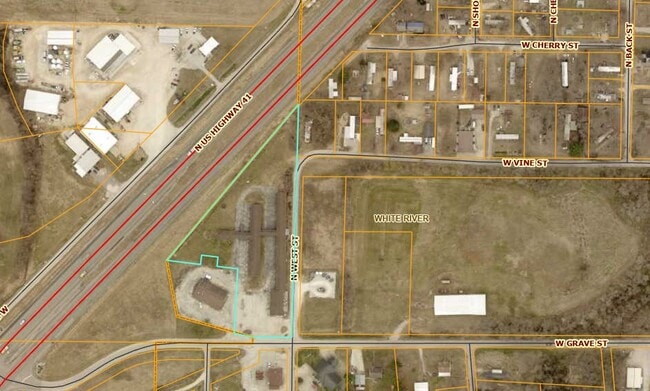
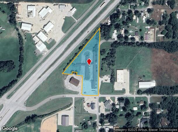
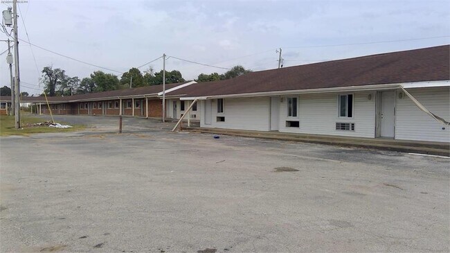
503 W Grave St, Patoka, IN 47666
This Property Is For Sale
NEARBY LISTINGS FOR SALE OR LEASE
-
-
View all Patoka listings for sale on LoopNet.com
Property Detail
503 W Grave St
Apartment
PT SE 23-1-11 3.02 AC
X
Gibson
18051C0115E
Indiana
2024
3.02 AC
2024
Gibson County
050401
Evansville
1,200 SF
26-04-23-400-000.209-020
DEMOGRAPHICS near 503 W Grave St
1 Mile
3 Mile
5 Mile
2024 Total Population
655
1,490
11,808
2029 Population
645
1,478
11,980
Pop Growth 2024-2029
(1.53%)
(0.81%)
+ 1.46%
Average Age
43
43
41
2024 Total Households
263
595
4,926
HH Growth 2024-2029
(1.52%)
(0.84%)
+ 1.48%
Median Household Inc
$57,031
$65,125
$57,020
Avg Household Size
2.50
2.50
2.30
2024 Avg HH Vehicles
2.00
2.00
2.00
Median Home Value
$139,436
$159,999
$130,308
Median Year Built
1969
1971
1972
Nearby Places
- Restaurants
- Banks
- Shops
- Fitness
- Groceries
PUBLIC TRANSPORTATION
AIRPORT
Evansville Regional
DRIVE
WALK
Distance
Evansville Regional
39 min
28.3 mi
Nearby Properties
Address
Land Use
TOTAL SIZE
Lot Size
Zoning
Address
Land Use
TOTAL SIZE
Lot Size
Zoning
17,940 SF
445.05 AC
Address
Land Use
TOTAL SIZE
Lot Size
Zoning
139,050 SF
49.13 AC
Address
Land Use
TOTAL SIZE
Lot Size
Zoning
20,434 SF
15 AC
Address
Land Use
TOTAL SIZE
Lot Size
Zoning
160 SF
146.25 AC
Address
Land Use
TOTAL SIZE
Lot Size
Zoning
1,490 SF
14.35 AC
Address
Land Use
TOTAL SIZE
Lot Size
Zoning
14,808 SF
8.02 AC
Address
Land Use
TOTAL SIZE
Lot Size
Zoning
11,700 SF
10 AC
Address
Land Use
TOTAL SIZE
Lot Size
Zoning
8,864 SF
47.69 AC
Address
Land Use
TOTAL SIZE
Lot Size
Zoning
9,280 SF
1.45 AC
Address
Land Use
TOTAL SIZE
Lot Size
Zoning
327.93 AC
Address
Land Use
TOTAL SIZE
Lot Size
Zoning
22,050 SF
7.35 AC
Address
Land Use
TOTAL SIZE
Lot Size
Zoning
243.39 AC
Address
Land Use
TOTAL SIZE
Lot Size
Zoning
6,480 SF
0.31 AC
Address
Land Use
TOTAL SIZE
Lot Size
Zoning
9,608 SF
3.76 AC
Address
Land Use
TOTAL SIZE
Lot Size
Zoning
268.77 AC
Address
Land Use
TOTAL SIZE
Lot Size
Zoning
68.43 AC
Address
Land Use
TOTAL SIZE
Lot Size
Zoning
294.40 AC
Address
Land Use
TOTAL SIZE
Lot Size
Zoning
153 AC
Address
Land Use
TOTAL SIZE
Lot Size
Zoning
138.15 AC
Address
Land Use
TOTAL SIZE
Lot Size
Zoning
4,000 SF
3.10 AC
Address
Land Use
TOTAL SIZE
Lot Size
Zoning
112.07 AC
Address
Land Use
TOTAL SIZE
Lot Size
Zoning
1,718 SF
171.41 AC
Address
Land Use
TOTAL SIZE
Lot Size
Zoning
142 AC
Address
Land Use
TOTAL SIZE
Lot Size
Zoning
4,840 SF
40.72 AC
Address
Land Use
TOTAL SIZE
Lot Size
Zoning
232.08 AC
Address
Land Use
TOTAL SIZE
Lot Size
Zoning
115 AC
Address
Land Use
TOTAL SIZE
Lot Size
Zoning
210 AC
Address
Land Use
TOTAL SIZE
Lot Size
Zoning
110 AC
Address
Land Use
TOTAL SIZE
Lot Size
Zoning
19,158 SF
2.18 AC
Address
Land Use
TOTAL SIZE
Lot Size
Zoning
10,395 SF
3.47 AC
The World's #1 Commercial Real Estate Marketplace
Connect with us
© 2025 CoStar Group
The information above has been obtained from sources believed reliable. While we do not doubt its accuracy we have not verified it and make no guarantee, warranty or representation about it. It is your responsibility to independently confirm its accuracy and completeness. Any projections, opinions, assumptions, or estimates used are for example only and do not represent the current or future performance of the property. The value of this transaction to you depends on tax and other factors which should be evaluated by your tax, financial, and legal advisors. You and your advisors should conduct a careful, independent investigation of the property to determine to your satisfaction the suitability of the property for your needs.