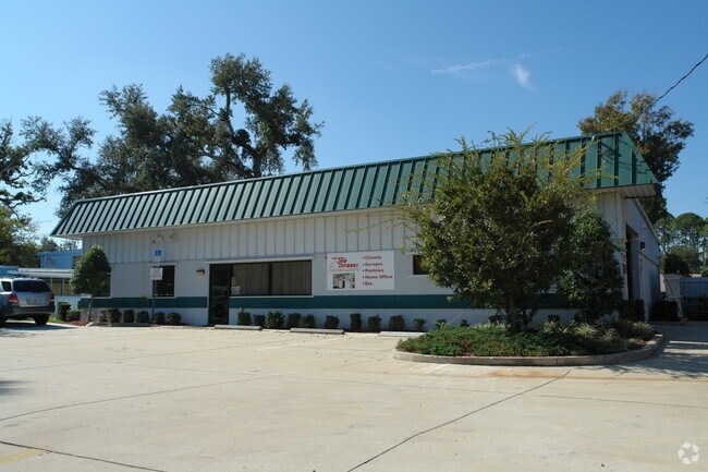
Property Record
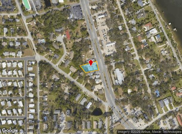
5030 S Ridgewood Ave, Port Orange, FL 32127

NEARBY LISTINGS FOR SALE OR LEASE
Property Detail
5030 S Ridgewood Ave
Deltona-Daytona Beach-Ormond Beach, FL
Norwood
6310-12-06-0110
LOTS 11 & 12 EXC RD RWY BLK 6 NORWOOD PER OR 4699 PG 0827 PER OR 8162 PG 4097
Lightindustrial
Volusia
X
Florida
12127C0388J
11,12
2025
0.39 AC
2025
South Beach Cities
082511
Deltona/Daytona Beach
3,710 SF
DEMOGRAPHICS near 5030 S Ridgewood Ave
1 Mile
3 Mile
5 Mile
2024 Total Population
5,616
52,090
112,487
2029 Population
6,225
58,226
125,220
Pop Growth 2024-2029
+ 10.84%
+ 11.78%
+ 11.32%
Average Age
48
48
47
2024 Total Households
2,747
24,476
51,268
HH Growth 2024-2029
+ 10.99%
+ 12.18%
+ 11.82%
Median Household Inc
$37,387
$53,548
$54,489
Avg Household Size
2.00
2.10
2.10
2024 Avg HH Vehicles
1.00
2.00
2.00
Median Home Value
$108,091
$231,743
$242,592
Median Year Built
1976
1981
1984
Nearby Places
Map Layers
Map Styles
 Street
 Aerial
- Restaurants
- Banks
- Shops
- Fitness
- Groceries
PUBLIC TRANSPORTATION
AIRPORT
Daytona Beach International
DRIVE
WALK
Distance
Daytona Beach International
17 min
8.3 mi
Orlando Sanford International
DRIVE
WALK
Distance
Orlando Sanford International
58 min
40.0 mi
Freight Ports
Port Canaveral
DRIVE
WALK
Distance
Port Canaveral
82 min
68.6 mi
Nearby Properties
Address
Land Use
TOTAL SIZE
Lot Size
Zoning
Address
Land Use
TOTAL SIZE
Lot Size
Zoning
448,867 SF
5.54 AC
Address
Land Use
TOTAL SIZE
Lot Size
Zoning
330,883 SF
19.59 AC
Address
Land Use
TOTAL SIZE
Lot Size
Zoning
325,744 SF
12.23 AC
Address
Land Use
TOTAL SIZE
Lot Size
Zoning
300,516 SF
70 AC
A2
Address
Land Use
TOTAL SIZE
Lot Size
Zoning
150,197 SF
16.07 AC
Address
Land Use
TOTAL SIZE
Lot Size
Zoning
94,338 SF
7.39 AC
Address
Land Use
TOTAL SIZE
Lot Size
Zoning
184,242 SF
14.43 AC
Address
Land Use
TOTAL SIZE
Lot Size
Zoning
9,952 SF
9.30 AC
16RMH
Address
Land Use
TOTAL SIZE
Lot Size
Zoning
269,160 SF
72.17 AC
16A
Address
Land Use
TOTAL SIZE
Lot Size
Zoning
156,994 SF
47.82 AC
16A
Address
Land Use
TOTAL SIZE
Lot Size
Zoning
155,590 SF
11.08 AC
16R3H
Address
Land Use
TOTAL SIZE
Lot Size
Zoning
9,061 SF
0.23 AC
16RMH
Address
Land Use
TOTAL SIZE
Lot Size
Zoning
148,848 SF
9.99 AC
16R3H
Address
Land Use
TOTAL SIZE
Lot Size
Zoning
3,886 SF
3.99 AC
16RMH
Address
Land Use
TOTAL SIZE
Lot Size
Zoning
Address
Land Use
TOTAL SIZE
Lot Size
Zoning
173,765 SF
0.32 AC
Address
Land Use
TOTAL SIZE
Lot Size
Zoning
9,833 SF
52.38 AC
16RMH
Address
Land Use
TOTAL SIZE
Lot Size
Zoning
131,376 SF
1.88 AC
03T
Address
Land Use
TOTAL SIZE
Lot Size
Zoning
4,166 SF
51.05 AC
Address
Land Use
TOTAL SIZE
Lot Size
Zoning
157,147 SF
47.79 AC
16A
Address
Land Use
TOTAL SIZE
Lot Size
Zoning
327,223 SF
21.66 AC
Address
Land Use
TOTAL SIZE
Lot Size
Zoning
19,753 SF
1.17 AC
Address
Land Use
TOTAL SIZE
Lot Size
Zoning
212,681 SF
21.50 AC
Address
Land Use
TOTAL SIZE
Lot Size
Zoning
111,379 SF
16.62 AC
Address
Land Use
TOTAL SIZE
Lot Size
Zoning
109,265 SF
13.45 AC
Address
Land Use
TOTAL SIZE
Lot Size
Zoning
138,930 SF
13.70 AC
16PCD
Address
Land Use
TOTAL SIZE
Lot Size
Zoning
79,205 SF
1.13 AC
03T
Address
Land Use
TOTAL SIZE
Lot Size
Zoning
95,455 SF
1.45 AC
03T
Address
Land Use
TOTAL SIZE
Lot Size
Zoning
91,967 SF
7.31 AC
16CC
Address
Land Use
TOTAL SIZE
Lot Size
Zoning
80,836 SF
3.03 AC
R3
The World's #1 Commercial Real Estate Marketplace
Connect with us
© 2025 CoStar Group
The information above has been obtained from sources believed reliable. While we do not doubt its accuracy we have not verified it and make no guarantee, warranty or representation about it. It is your responsibility to independently confirm its accuracy and completeness. Any projections, opinions, assumptions, or estimates used are for example only and do not represent the current or future performance of the property. The value of this transaction to you depends on tax and other factors which should be evaluated by your tax, financial, and legal advisors. You and your advisors should conduct a careful, independent investigation of the property to determine to your satisfaction the suitability of the property for your needs.