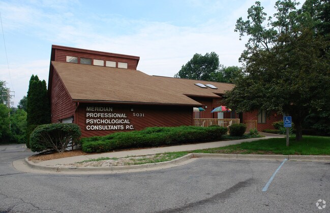
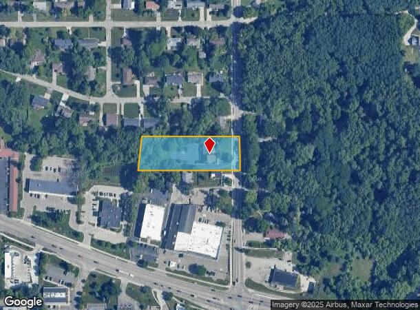
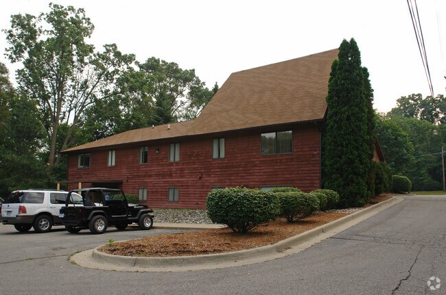
Property Record
5031 Park Lake Rd, East Lansing, MI 48823
NEARBY LISTINGS FOR SALE OR LEASE
Property Detail
5031 Park Lake Rd
02-02-17-460-015
Eastwood Acres
Officebuilding
M17-39-1 BEG AT PT WHICH LIES 426.65 FT W OF E 1/8 LN OF SEC 17 WHICH IS 1095 FT S OF NE COR OF SW 1/4 OF SE 1/4 SEC 17- E
X
Ingham
26065C0152D
Michigan
2024
1.38 AC
2025
East Lansing
004301
West Michigan
2,504 SF
Lansing-East Lansing, MI
DEMOGRAPHICS near 5031 Park Lake Rd
1 Mile
3 Mile
5 Mile
2024 Total Population
7,269
67,949
126,152
2029 Population
7,167
67,936
126,244
Pop Growth 2024-2029
(1.40%)
(0.02%)
+ 0.07%
Average Age
34
35
36
2024 Total Households
3,378
27,971
53,595
HH Growth 2024-2029
(1.48%)
0.00%
+ 0.05%
Median Household Inc
$42,047
$57,111
$56,083
Avg Household Size
2.10
2.20
2.20
2024 Avg HH Vehicles
2.00
2.00
2.00
Median Home Value
$221,266
$258,882
$220,161
Median Year Built
1982
1978
1977
Nearby Places
Map Layers
Map Styles
 Street
 Aerial
- Restaurants
- Banks
- Shops
- Fitness
- Groceries
PUBLIC TRANSPORTATION
COMMUTER RAIL
East Lansing Amtrak Station (Blue Water - Amtrak)
DRIVE
WALK
Distance
East Lansing Amtrak Station (Blue Water - Amtrak)
8 min
3.4 mi
AIRPORT
Capital Region International
DRIVE
WALK
Distance
Capital Region International
20 min
9.0 mi
Freight Ports
Port of Toledo
DRIVE
WALK
Distance
Port of Toledo
145 min
119.5 mi
Nearby Properties
Address
Land Use
TOTAL SIZE
Lot Size
Zoning
Address
Land Use
TOTAL SIZE
Lot Size
Zoning
66,818 SF
0.99 AC
EV
Address
Land Use
TOTAL SIZE
Lot Size
Zoning
14,304 SF
3.37 AC
MIXED Z
Address
Land Use
TOTAL SIZE
Lot Size
Zoning
49,959 SF
15.71 AC
RP
Address
Land Use
TOTAL SIZE
Lot Size
Zoning
222,869 SF
0.10 AC
B3
Address
Land Use
TOTAL SIZE
Lot Size
Zoning
98,513 SF
7.86 AC
C-2
Address
Land Use
TOTAL SIZE
Lot Size
Zoning
274,720 SF
10.55 AC
Address
Land Use
TOTAL SIZE
Lot Size
Zoning
12,435 SF
0.52 AC
B3
Address
Land Use
TOTAL SIZE
Lot Size
Zoning
13.13 AC
Address
Land Use
TOTAL SIZE
Lot Size
Zoning
812,293 SF
62.18 AC
C-3
Address
Land Use
TOTAL SIZE
Lot Size
Zoning
149,799 SF
9.60 AC
Address
Land Use
TOTAL SIZE
Lot Size
Zoning
179,376 SF
6.03 AC
RM32
Address
Land Use
TOTAL SIZE
Lot Size
Zoning
32,946 SF
64.40 AC
RD
Address
Land Use
TOTAL SIZE
Lot Size
Zoning
51,122 SF
9.05 AC
RAA
Address
Land Use
TOTAL SIZE
Lot Size
Zoning
188,175 SF
4.37 AC
EV
Address
Land Use
TOTAL SIZE
Lot Size
Zoning
215,335 SF
38.10 AC
RM08
Address
Land Use
TOTAL SIZE
Lot Size
Zoning
129,030 SF
RP
Address
Land Use
TOTAL SIZE
Lot Size
Zoning
61,198 SF
13.10 AC
C-2
Address
Land Use
TOTAL SIZE
Lot Size
Zoning
119,182 SF
19.33 AC
C-3
Address
Land Use
TOTAL SIZE
Lot Size
Zoning
35,523 SF
6.23 AC
C-2
Address
Land Use
TOTAL SIZE
Lot Size
Zoning
38,332 SF
7.44 AC
C-2
Address
Land Use
TOTAL SIZE
Lot Size
Zoning
9,628 SF
1.86 AC
B2
Address
Land Use
TOTAL SIZE
Lot Size
Zoning
179,376 SF
5.68 AC
Address
Land Use
TOTAL SIZE
Lot Size
Zoning
9,280 SF
24.38 AC
RC
Address
Land Use
TOTAL SIZE
Lot Size
Zoning
141,026 SF
0.45 AC
B3
Address
Land Use
TOTAL SIZE
Lot Size
Zoning
4,784 SF
24.06 AC
RC
Address
Land Use
TOTAL SIZE
Lot Size
Zoning
189,280 SF
6.03 AC
RCC
Address
Land Use
TOTAL SIZE
Lot Size
Zoning
112,248 SF
3.70 AC
B2
Address
Land Use
TOTAL SIZE
Lot Size
Zoning
25,308 SF
45.28 AC
RD
Address
Land Use
TOTAL SIZE
Lot Size
Zoning
131,040 SF
2.36 AC
Address
Land Use
TOTAL SIZE
Lot Size
Zoning
15,067 SF
15.64 AC
RC
The World's #1 Commercial Real Estate Marketplace
Connect with us
© 2025 CoStar Group
The information above has been obtained from sources believed reliable. While we do not doubt its accuracy we have not verified it and make no guarantee, warranty or representation about it. It is your responsibility to independently confirm its accuracy and completeness. Any projections, opinions, assumptions, or estimates used are for example only and do not represent the current or future performance of the property. The value of this transaction to you depends on tax and other factors which should be evaluated by your tax, financial, and legal advisors. You and your advisors should conduct a careful, independent investigation of the property to determine to your satisfaction the suitability of the property for your needs.