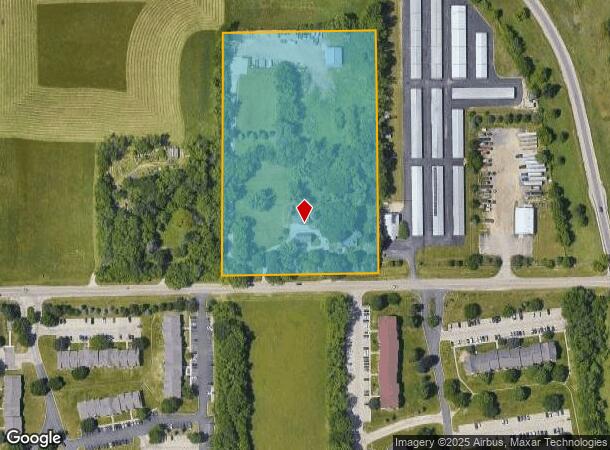
Property Record
5034 Linden Rd, Rockford, IL 61109
NEARBY LISTINGS FOR SALE OR LEASE
Property Detail
5034 Linden Rd
Rockford, IL
Winnebago
16-09-151-005
Illinois
Sfr
7.69 AC
X
I-39 Corr/Winnebago Cnty
17141C0150D
Chicago
5,466 SF
DEMOGRAPHICS near 5034 Linden Rd
1 Mile
3 Mile
5 Mile
2024 Total Population
3,340
39,802
96,352
2029 Population
3,303
39,166
95,098
Pop Growth 2024-2029
(1.11%)
(1.60%)
(1.30%)
Average Age
38
40
40
2024 Total Households
1,782
16,124
39,402
HH Growth 2024-2029
(1.07%)
(1.57%)
(1.29%)
Median Household Inc
$44,315
$54,829
$51,286
Avg Household Size
1.90
2.40
2.40
2024 Avg HH Vehicles
2.00
2.00
2.00
Median Home Value
$161,538
$128,027
$122,021
Median Year Built
1975
1972
1966
Nearby Places
Map Layers
Map Styles
 Street
 Aerial
- Restaurants
- Banks
- Shops
- Fitness
- Groceries
PUBLIC TRANSPORTATION
AIRPORT
Chicago/Rockford International
DRIVE
WALK
Distance
Chicago/Rockford International
17 min
7.5 mi
Freight Ports
Port Milwaukee
DRIVE
WALK
Distance
Port Milwaukee
112 min
95.6 mi
SALE & LEASE HISTORY
LISTING DATE
SALE/LEASE

Sep 24, 2016
For Sale
Mar 25, 2019
For Sale
Aug 28, 2024
For Sale
Nearby Properties
Address
Land Use
TOTAL SIZE
Lot Size
Zoning
Address
Land Use
TOTAL SIZE
Lot Size
Zoning
559,880 SF
56.87 AC
CC
Address
Land Use
TOTAL SIZE
Lot Size
Zoning
680,704 SF
43.11 AC
R3
Address
Land Use
TOTAL SIZE
Lot Size
Zoning
920,723 SF
82.07 AC
Address
Land Use
TOTAL SIZE
Lot Size
Zoning
551,795 SF
36 AC
R3
Address
Land Use
TOTAL SIZE
Lot Size
Zoning
96,130 SF
12.47 AC
R2
Address
Land Use
TOTAL SIZE
Lot Size
Zoning
147,900 SF
7.78 AC
Address
Land Use
TOTAL SIZE
Lot Size
Zoning
77,718 SF
11.12 AC
C2
Address
Land Use
TOTAL SIZE
Lot Size
Zoning
199,330 SF
15.02 AC
CG
Address
Land Use
TOTAL SIZE
Lot Size
Zoning
145,014 SF
12.06 AC
CC
Address
Land Use
TOTAL SIZE
Lot Size
Zoning
174,318 SF
17.97 AC
Address
Land Use
TOTAL SIZE
Lot Size
Zoning
133,394 SF
14.08 AC
C3
Address
Land Use
TOTAL SIZE
Lot Size
Zoning
86,720 SF
3.91 AC
R4
Address
Land Use
TOTAL SIZE
Lot Size
Zoning
10,970 SF
26.80 AC
R2
Address
Land Use
TOTAL SIZE
Lot Size
Zoning
111,311 SF
7.85 AC
I1
Address
Land Use
TOTAL SIZE
Lot Size
Zoning
128,066 SF
4.15 AC
CC
Address
Land Use
TOTAL SIZE
Lot Size
Zoning
41,388 SF
6.90 AC
R3
Address
Land Use
TOTAL SIZE
Lot Size
Zoning
10.92 AC
Address
Land Use
TOTAL SIZE
Lot Size
Zoning
146,148 SF
1.14 AC
CC
Address
Land Use
TOTAL SIZE
Lot Size
Zoning
52,340 SF
14.36 AC
Address
Land Use
TOTAL SIZE
Lot Size
Zoning
72,451 SF
8.50 AC
I1
Address
Land Use
TOTAL SIZE
Lot Size
Zoning
73,558 SF
10.20 AC
CC
Address
Land Use
TOTAL SIZE
Lot Size
Zoning
23,721 SF
3.66 AC
R2
Address
Land Use
TOTAL SIZE
Lot Size
Zoning
93,480 SF
9.30 AC
CC
Address
Land Use
TOTAL SIZE
Lot Size
Zoning
57,808 SF
6.64 AC
CG
Address
Land Use
TOTAL SIZE
Lot Size
Zoning
73,998 SF
7.56 AC
I1
Address
Land Use
TOTAL SIZE
Lot Size
Zoning
27,920 SF
R2
Address
Land Use
TOTAL SIZE
Lot Size
Zoning
78,334 SF
9.78 AC
I3
Address
Land Use
TOTAL SIZE
Lot Size
Zoning
64,666 SF
2.35 AC
C2
Address
Land Use
TOTAL SIZE
Lot Size
Zoning
310,853 SF
14.51 AC
C2
Address
Land Use
TOTAL SIZE
Lot Size
Zoning
28,876 SF
3.96 AC
I1
The World's #1 Commercial Real Estate Marketplace
Connect with us
© 2025 CoStar Group
The information above has been obtained from sources believed reliable. While we do not doubt its accuracy we have not verified it and make no guarantee, warranty or representation about it. It is your responsibility to independently confirm its accuracy and completeness. Any projections, opinions, assumptions, or estimates used are for example only and do not represent the current or future performance of the property. The value of this transaction to you depends on tax and other factors which should be evaluated by your tax, financial, and legal advisors. You and your advisors should conduct a careful, independent investigation of the property to determine to your satisfaction the suitability of the property for your needs.