Property Record
5035 Dawn Dr, Lumberton, NC 28360

Save to a Folder
{{folder.Name}}
{{folder.ListingIds.length}} Properties
{{folder.ListingIds.length}} Property
Create a New Folder
Property Detail
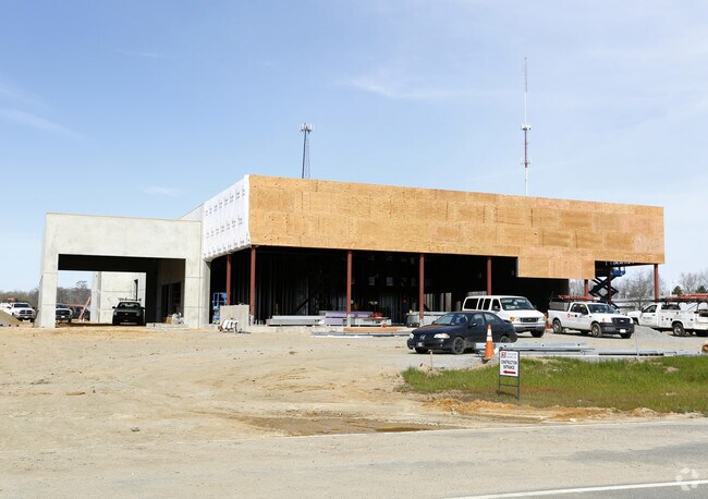
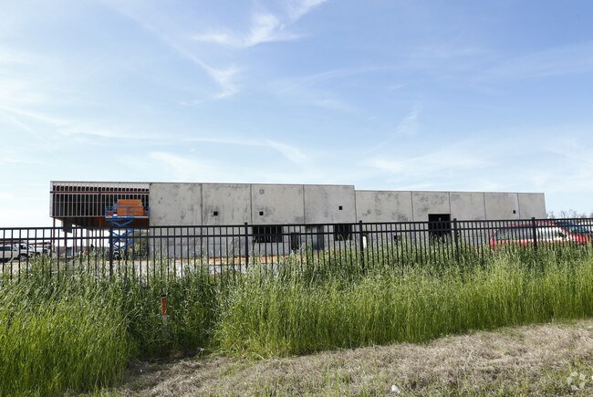
5035 Dawn Dr
1006-01-01217
A G G FRENCH LAND AA MEET ING HALL
Autorepair
Robeson
B and X Area of moderate flood hazard, usually the area between the limits of the 100-year and 500-year floods.
North Carolina
2025
3.50 AC
2025
North Carolina Southeast Area
960701
Other Market Areas
22,010 SF
Lumberton, NC
NEARBY LISTINGS FOR SALE OR LEASE
DEMOGRAPHICS near 5035 Dawn Dr
1 mile
3 mile
5 mile
2025 Total Population
1,844
16,650
31,621
2030 Population
1,883
17,063
32,708
Pop Growth 2025-2030
+ 2.11%
+ 2.48%
+ 3.44%
Average Age
45
40
39
2025 Total Households
739
6,528
12,129
HH Growth 2025-2030
+ 2.30%
+ 2.53%
+ 3.58%
Median Household Inc
$79,545
$55,414
$47,059
Avg Household Size
2.30
2.40
2.40
2025 Avg HH Vehicles
2.00
2.00
2.00
Median Home Value
$246,616
$162,875
$130,969
Median Year Built
1991
1980
1980
Nearby Places
Map Layers
Map Styles
 Street
 Aerial
Layers
 Traffic
 Biking
Places
Listings with unknown addresses are not visible on the map
- Restaurants
- Banks
- Shops
- Fitness
- Groceries
PUBLIC TRANSPORTATION
AIRPORT
Fayetteville Regional/Grannis Field
Drive
Walk
Distance
Fayetteville Regional/Grannis Field
34 min
26.0 mi
Freight Ports
Port of Wilmington
Drive
Walk
Distance
Port of Wilmington
113 min
77.1 mi
Nearby Properties
Address
Land Use
TOTAL SIZE
Lot Size
Zoning
Address
Land Use
TOTAL SIZE
Lot Size
Zoning
116,616 SF
10.18 AC
B6
Address
Land Use
TOTAL SIZE
Lot Size
Zoning
82,115 SF
39.22 AC
R15
Address
Land Use
TOTAL SIZE
Lot Size
Zoning
24,173 SF
44.32 AC
B3
Address
Land Use
TOTAL SIZE
Lot Size
Zoning
54,400 SF
69.94 AC
R20
Address
Land Use
TOTAL SIZE
Lot Size
Zoning
204,470 SF
18.21 AC
B4
Address
Land Use
TOTAL SIZE
Lot Size
Zoning
88,206 SF
19.07 AC
B4
Address
Land Use
TOTAL SIZE
Lot Size
Zoning
134,160 SF
0.26 AC
B6
Address
Land Use
TOTAL SIZE
Lot Size
Zoning
128,531 SF
22.20 AC
B4
Address
Land Use
TOTAL SIZE
Lot Size
Zoning
139,629 SF
19.05 AC
B4
Address
Land Use
TOTAL SIZE
Lot Size
Zoning
134,785 SF
17.82 AC
CUPB4
Address
Land Use
TOTAL SIZE
Lot Size
Zoning
36,329 SF
16.87 AC
R6
Address
Land Use
TOTAL SIZE
Lot Size
Zoning
60,906 SF
26.55 AC
Address
Land Use
TOTAL SIZE
Lot Size
Zoning
90,800 SF
36.65 AC
R20
Address
Land Use
TOTAL SIZE
Lot Size
Zoning
69,234 SF
3.18 AC
B5
Address
Land Use
TOTAL SIZE
Lot Size
Zoning
59,624 SF
2.19 AC
B4
Address
Land Use
TOTAL SIZE
Lot Size
Zoning
56,932 SF
1.37 AC
B4
Address
Land Use
TOTAL SIZE
Lot Size
Zoning
69,765 SF
9.51 AC
B4
Address
Land Use
TOTAL SIZE
Lot Size
Zoning
23,442 SF
7.22 AC
R6
Address
Land Use
TOTAL SIZE
Lot Size
Zoning
63,964 SF
5.65 AC
B5
Address
Land Use
TOTAL SIZE
Lot Size
Zoning
33,546 SF
4.97 AC
B4
Address
Land Use
TOTAL SIZE
Lot Size
Zoning
48,260 SF
2.95 AC
B5
Address
Land Use
TOTAL SIZE
Lot Size
Zoning
95,143 SF
7.55 AC
B4
Address
Land Use
TOTAL SIZE
Lot Size
Zoning
51,003 SF
8.49 AC
B3
Address
Land Use
TOTAL SIZE
Lot Size
Zoning
34,998 SF
3.15 AC
B5
Address
Land Use
TOTAL SIZE
Lot Size
Zoning
59,635 SF
10.24 AC
R11
Address
Land Use
TOTAL SIZE
Lot Size
Zoning
42,543 SF
14.78 AC
B4
Address
Land Use
TOTAL SIZE
Lot Size
Zoning
75,000 SF
13.84 AC
B4
Address
Land Use
TOTAL SIZE
Lot Size
Zoning
54,726 SF
16.22 AC
RA
Address
Land Use
TOTAL SIZE
Lot Size
Zoning
7,700 SF
10.66 AC
M1
Address
Land Use
TOTAL SIZE
Lot Size
Zoning
39,439 SF
1.10 AC
B5
The World's #1 Commercial Real Estate Marketplace
Connect with us
© 2026 CoStar Group
The information above has been obtained from sources believed reliable. While we do not doubt its accuracy we have not verified it and make no guarantee, warranty or representation about it. It is your responsibility to independently confirm its accuracy and completeness. Any projections, opinions, assumptions, or estimates used are for example only and do not represent the current or future performance of the property. The value of this transaction to you depends on tax and other factors which should be evaluated by your tax, financial, and legal advisors. You and your advisors should conduct a careful, independent investigation of the property to determine to your satisfaction the suitability of the property for your needs.