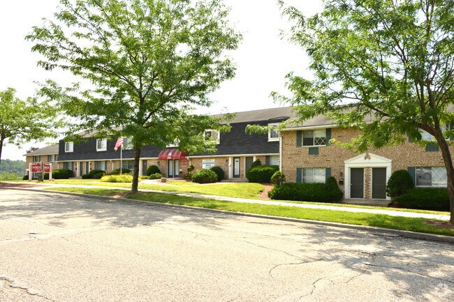
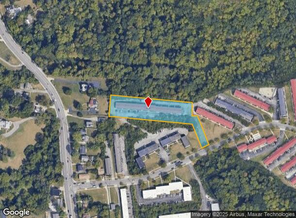
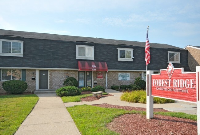
Property Record
5036 Hawaiian Ter, Cincinnati, OH 45223
NEARBY LISTINGS FOR SALE OR LEASE
Property Detail
5036 Hawaiian Ter
Cincinnati, OH-KY-IN
Hawaiian Village Sub
227-0001-0106
HAWAIIAN TER 50.06 FT IRR PT LOT 3 HAWAIIAN VILLAGE SUB BLK B
Apartment
Hamilton
X
Ohio
39061C0212E
3
2024
1.80 AC
2024
Mount Airy
008501
Cincinnati/Dayton
37,350 SF
DEMOGRAPHICS near 5036 Hawaiian Ter
1 Mile
3 Mile
5 Mile
2024 Total Population
9,452
97,920
283,357
2029 Population
9,703
97,456
281,703
Pop Growth 2024-2029
+ 2.66%
(0.47%)
(0.58%)
Average Age
37
39
38
2024 Total Households
3,786
41,900
117,385
HH Growth 2024-2029
+ 2.56%
(0.63%)
(0.68%)
Median Household Inc
$32,878
$45,134
$46,921
Avg Household Size
2.30
2.20
2.20
2024 Avg HH Vehicles
1.00
1.00
2.00
Median Home Value
$151,980
$156,106
$157,777
Median Year Built
1968
1960
1959
Nearby Places
Map Layers
Map Styles
 Street
 Aerial
- Restaurants
- Banks
- Shops
- Fitness
- Groceries
PUBLIC TRANSPORTATION
COMMUTER RAIL
Cincinnati Union Terminal (Cardinal - Amtrak)
DRIVE
WALK
Distance
Cincinnati Union Terminal (Cardinal - Amtrak)
14 min
6.5 mi
AIRPORT
Cincinnati/Northern Kentucky International
DRIVE
WALK
Distance
Cincinnati/Northern Kentucky International
38 min
20.5 mi
Freight Ports
Port of Toledo
DRIVE
WALK
Distance
Port of Toledo
244 min
205.3 mi
Nearby Properties
Address
Land Use
TOTAL SIZE
Lot Size
Zoning
Address
Land Use
TOTAL SIZE
Lot Size
Zoning
Address
Land Use
TOTAL SIZE
Lot Size
Zoning
26.16 AC
Address
Land Use
TOTAL SIZE
Lot Size
Zoning
112.35 AC
RM20
Address
Land Use
TOTAL SIZE
Lot Size
Zoning
29.60 AC
IR
Address
Land Use
TOTAL SIZE
Lot Size
Zoning
Address
Land Use
TOTAL SIZE
Lot Size
Zoning
60.86 AC
Address
Land Use
TOTAL SIZE
Lot Size
Zoning
Address
Land Use
TOTAL SIZE
Lot Size
Zoning
6,620 SF
16.91 AC
Address
Land Use
TOTAL SIZE
Lot Size
Zoning
41,564 SF
13.21 AC
Address
Land Use
TOTAL SIZE
Lot Size
Zoning
11,664 SF
29.27 AC
RM20
Address
Land Use
TOTAL SIZE
Lot Size
Zoning
50.02 AC
Address
Land Use
TOTAL SIZE
Lot Size
Zoning
13.81 AC
Address
Land Use
TOTAL SIZE
Lot Size
Zoning
Address
Land Use
TOTAL SIZE
Lot Size
Zoning
60,614 SF
13.35 AC
SF6
Address
Land Use
TOTAL SIZE
Lot Size
Zoning
Address
Land Use
TOTAL SIZE
Lot Size
Zoning
8.66 AC
SF2
Address
Land Use
TOTAL SIZE
Lot Size
Zoning
6.15 AC
SF2
Address
Land Use
TOTAL SIZE
Lot Size
Zoning
10,036 SF
22.06 AC
RM20
Address
Land Use
TOTAL SIZE
Lot Size
Zoning
8.57 AC
Address
Land Use
TOTAL SIZE
Lot Size
Zoning
1,860 SF
12.01 AC
A2
Address
Land Use
TOTAL SIZE
Lot Size
Zoning
20.33 AC
SF6
Address
Land Use
TOTAL SIZE
Lot Size
Zoning
50,196 SF
17.64 AC
RM20
Address
Land Use
TOTAL SIZE
Lot Size
Zoning
49,056 SF
5.70 AC
RM20
Address
Land Use
TOTAL SIZE
Lot Size
Zoning
148,224 SF
5.50 AC
RM12
Address
Land Use
TOTAL SIZE
Lot Size
Zoning
Address
Land Use
TOTAL SIZE
Lot Size
Zoning
5,984 SF
15.91 AC
Address
Land Use
TOTAL SIZE
Lot Size
Zoning
4.28 AC
OO
Address
Land Use
TOTAL SIZE
Lot Size
Zoning
84,810 SF
12.66 AC
C
Address
Land Use
TOTAL SIZE
Lot Size
Zoning
3.97 AC
RM20
Address
Land Use
TOTAL SIZE
Lot Size
Zoning
9.47 AC
SF6
The World's #1 Commercial Real Estate Marketplace
Connect with us
© 2025 CoStar Group
The information above has been obtained from sources believed reliable. While we do not doubt its accuracy we have not verified it and make no guarantee, warranty or representation about it. It is your responsibility to independently confirm its accuracy and completeness. Any projections, opinions, assumptions, or estimates used are for example only and do not represent the current or future performance of the property. The value of this transaction to you depends on tax and other factors which should be evaluated by your tax, financial, and legal advisors. You and your advisors should conduct a careful, independent investigation of the property to determine to your satisfaction the suitability of the property for your needs.