Property Record
5037 E Brundage Ln, Bakersfield, CA 93307
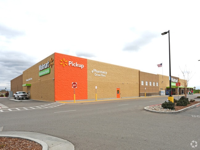

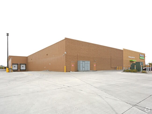

Property Detail
5037 E Brundage Ln
173-680-06-00-7
SECTION 2 , TOWNSHIP 30 , RANGE 28 , QUARTER
Supermarket
Kern
C-2 PD
California
B and X Area of moderate flood hazard, usually the area between the limits of the 100-year and 500-year floods.
5.96 AC
2024
Southeast Bakersfield
2025
Bakersfield
002303
Bakersfield-Delano, CA
41,089 SF
NEARBY LISTINGS FOR SALE OR LEASE
DEMOGRAPHICS near 5037 E Brundage Ln
1 mile
3 mile
5 mile
2025 Total Population
12,450
98,592
218,485
2030 Population
12,662
99,626
220,873
Pop Growth 2025-2030
+ 1.70%
+ 1.05%
+ 1.09%
Average Age
33
33
34
2025 Total Households
3,203
27,213
65,139
HH Growth 2025-2030
+ 1.65%
+ 1.03%
+ 1.13%
Median Household Inc
$61,200
$50,265
$52,787
Avg Household Size
3.80
3.50
3.20
2025 Avg HH Vehicles
2.00
2.00
2.00
Median Home Value
$295,603
$268,153
$282,893
Median Year Built
1996
1971
1970
Nearby Places
Map Layers
Map Styles
 Street
 Aerial
Layers
 Traffic
 Biking
Places
Listings with unknown addresses are not visible on the map
- Restaurants
- Banks
- Shops
- Fitness
- Groceries
PUBLIC TRANSPORTATION
COMMUTER RAIL
Drive
Walk
Distance
10 min
4.7 mi
AIRPORT
Meadows Field
Drive
Walk
Distance
Meadows Field
22 min
12.2 mi
Nearby Properties
Address
Land Use
TOTAL SIZE
Lot Size
Zoning
Address
Land Use
TOTAL SIZE
Lot Size
Zoning
18,000 SF
35.01 AC
M-2
Address
Land Use
TOTAL SIZE
Lot Size
Zoning
825 SF
9.60 AC
M-3
Address
Land Use
TOTAL SIZE
Lot Size
Zoning
112,052 SF
3.14 AC
R3
Address
Land Use
TOTAL SIZE
Lot Size
Zoning
66,139 SF
4.48 AC
CO
Address
Land Use
TOTAL SIZE
Lot Size
Zoning
127,308 SF
8.25 AC
R-2
Address
Land Use
TOTAL SIZE
Lot Size
Zoning
161,946 SF
17.84 AC
C2 PD
Address
Land Use
TOTAL SIZE
Lot Size
Zoning
79,987 SF
3.22 AC
SP
Address
Land Use
TOTAL SIZE
Lot Size
Zoning
50,445 SF
2.53 AC
C2
Address
Land Use
TOTAL SIZE
Lot Size
Zoning
10.31 AC
Address
Land Use
TOTAL SIZE
Lot Size
Zoning
2.14 AC
C2
Address
Land Use
TOTAL SIZE
Lot Size
Zoning
17,567 SF
19.39 AC
M2
Address
Land Use
TOTAL SIZE
Lot Size
Zoning
19,350 SF
2.05 AC
Address
Land Use
TOTAL SIZE
Lot Size
Zoning
115,058 SF
13.02 AC
C2
Address
Land Use
TOTAL SIZE
Lot Size
Zoning
1.06 AC
R-1
Address
Land Use
TOTAL SIZE
Lot Size
Zoning
0.41 AC
R1
Address
Land Use
TOTAL SIZE
Lot Size
Zoning
74,890 SF
3.61 AC
SP
Address
Land Use
TOTAL SIZE
Lot Size
Zoning
74,890 SF
3.75 AC
SP
Address
Land Use
TOTAL SIZE
Lot Size
Zoning
68,264 SF
6.56 AC
C2
Address
Land Use
TOTAL SIZE
Lot Size
Zoning
4.94 AC
R-3
Address
Land Use
TOTAL SIZE
Lot Size
Zoning
46,522 SF
3.35 AC
R2
Address
Land Use
TOTAL SIZE
Lot Size
Zoning
22,944 SF
6.51 AC
R2
Address
Land Use
TOTAL SIZE
Lot Size
Zoning
29,440 SF
2.83 AC
C-2
Address
Land Use
TOTAL SIZE
Lot Size
Zoning
101,437 SF
9.05 AC
PCD
Address
Land Use
TOTAL SIZE
Lot Size
Zoning
11.05 AC
C2/PCD
Address
Land Use
TOTAL SIZE
Lot Size
Zoning
95,258 SF
5.34 AC
PUD
Address
Land Use
TOTAL SIZE
Lot Size
Zoning
171,948 SF
10.93 AC
M-3
Address
Land Use
TOTAL SIZE
Lot Size
Zoning
9,627 SF
12.37 AC
C2
Address
Land Use
TOTAL SIZE
Lot Size
Zoning
93,070 SF
7.98 AC
PUD
Address
Land Use
TOTAL SIZE
Lot Size
Zoning
97,900 SF
6.98 AC
M-2 PD
Address
Land Use
TOTAL SIZE
Lot Size
Zoning
44,779 SF
2.17 AC
M2
The World's #1 Commercial Real Estate Marketplace
Connect with us
© 2026 CoStar Group
The information above has been obtained from sources believed reliable. While we do not doubt its accuracy we have not verified it and make no guarantee, warranty or representation about it. It is your responsibility to independently confirm its accuracy and completeness. Any projections, opinions, assumptions, or estimates used are for example only and do not represent the current or future performance of the property. The value of this transaction to you depends on tax and other factors which should be evaluated by your tax, financial, and legal advisors. You and your advisors should conduct a careful, independent investigation of the property to determine to your satisfaction the suitability of the property for your needs.