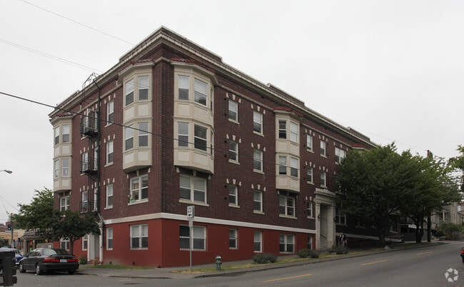
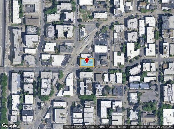
Property Record
504 E Denny Way, Seattle, WA 98122

NEARBY LISTINGS FOR SALE OR LEASE
Property Detail
504 E Denny Way
Seattle-Tacoma-Bellevue, WA
Pontius 2Nd Add Supl
684820-0650
PONTIUS 2ND ADD SUPL BEG ON WLY LN BLK 48 OF SUPL PLAT OF PONTIUS SECOND ADD AAP 300 FT S OF NW COR SD BLK WCH PT IS NW COR LOT 6 TH SLY ALG WLY LN SD BLK 72.99 FT TO NLY MGN E DENNY WAY TH ELY ALG SD NLY MGN 120 FT TO WLY LN OF ALLEY TH NLY ALG SD W
Apartment
King
X
Washington
53033C0630G
6
2025
0.20 AC
2024
Capitol Hill
007405
Seattle/Puget Sound
24,000 SF
DEMOGRAPHICS near 504 E Denny Way
1 mile
3 mile
5 mile
2024 Total Population
96,267
276,017
514,008
2029 Population
98,906
282,448
522,782
Pop Growth 2024-2029
+ 2.74%
+ 2.33%
+ 1.71%
Average Age
37
38
38
2024 Total Households
59,844
149,885
255,259
HH Growth 2024-2029
+ 2.72%
+ 2.36%
+ 1.80%
Median Household Inc
$107,481
$110,415
$117,415
Avg Household Size
1.50
1.70
1.90
2024 Avg HH Vehicles
1.00
1.00
1.00
Median Home Value
$897,970
$996,734
$971,665
Median Year Built
2000
1990
1982
Nearby Places
Map Layers
Map Styles
 Street
 Aerial
Transit
 Traffic
 Biking
Places
Listings with unknown addresses are not visible on the map
- Restaurants
- Banks
- Shops
- Fitness
- Groceries
PUBLIC TRANSPORTATION
TRANSIT/SUBWAY
Westlake & Denny (South Lake Union Streetcar - Seattle Streetcar)
Drive
Walk
Distance
Westlake & Denny (South Lake Union Streetcar - Seattle Streetcar)
3 min
13 min
0.6 mi
Westlake & 7th South (South Lake Union Streetcar - Seattle Streetcar)
Drive
Walk
Distance
Westlake & 7th South (South Lake Union Streetcar - Seattle Streetcar)
3 min
15 min
0.7 mi
Terry & Thomas (South Lake Union Streetcar - Seattle Streetcar)
Drive
Walk
Distance
Terry & Thomas (South Lake Union Streetcar - Seattle Streetcar)
3 min
15 min
0.8 mi
Westlake Center (Seattle Center Monorail - Seattle Monorail Services (Seattle Monorail))
Drive
Walk
Distance
Westlake Center (Seattle Center Monorail - Seattle Monorail Services (Seattle Monorail))
3 min
15 min
0.8 mi
Westlake (Central Link - Central Puget Sound Regional Transit Authority Rail (Link Light Rail/Sounder))
Drive
Walk
Distance
Westlake (Central Link - Central Puget Sound Regional Transit Authority Rail (Link Light Rail/Sounder))
3 min
16 min
0.8 mi
COMMUTER RAIL
King Street (Seattle) Station (Sounder South Line - Central Puget Sound Regional Transit Authority Rail (Link Light Rail/Sounder))
Drive
Walk
Distance
King Street (Seattle) Station (Sounder South Line - Central Puget Sound Regional Transit Authority Rail (Link Light Rail/Sounder))
6 min
2.0 mi
AIRPORT
Seattle-Tacoma International
Drive
Walk
Distance
Seattle-Tacoma International
24 min
15.2 mi
Seattle Paine Field International
Drive
Walk
Distance
Seattle Paine Field International
33 min
23.0 mi
Freight Ports
Port of Seattle
Drive
Walk
Distance
Port of Seattle
12 min
5.7 mi
SALE & LEASE HISTORY
LISTING DATE
SALE/LEASE

Mar 19, 2025
For Sale
Nearby Properties
Address
Land Use
TOTAL SIZE
Lot Size
Zoning
Address
Land Use
TOTAL SIZE
Lot Size
Zoning
800,000 SF
8.57 AC
SM-UP 95 (
Address
Land Use
TOTAL SIZE
Lot Size
Zoning
471.20 AC
MIO-37-LR1
Address
Land Use
TOTAL SIZE
Lot Size
Zoning
2.84 AC
DMC 340/29
Address
Land Use
TOTAL SIZE
Lot Size
Zoning
793,990 SF
30.81 AC
UI U/85
Address
Land Use
TOTAL SIZE
Lot Size
Zoning
946,212 SF
1.58 AC
DMC 340/29
Address
Land Use
TOTAL SIZE
Lot Size
Zoning
686,722 SF
1.26 AC
SM-SLU 240
Address
Land Use
TOTAL SIZE
Lot Size
Zoning
36,864 SF
8.02 AC
SM-UP 95 (
Address
Land Use
TOTAL SIZE
Lot Size
Zoning
992,925 SF
4.28 AC
MIO-240-HR
Address
Land Use
TOTAL SIZE
Lot Size
Zoning
1,526,621 SF
1.36 AC
DOC1 U/450
Address
Land Use
TOTAL SIZE
Lot Size
Zoning
716,128 SF
1.41 AC
SM-SLU 175
Address
Land Use
TOTAL SIZE
Lot Size
Zoning
1,062,251 SF
1.47 AC
DOC2 500/3
Address
Land Use
TOTAL SIZE
Lot Size
Zoning
763,898 SF
2.03 AC
DOC2 500/3
Address
Land Use
TOTAL SIZE
Lot Size
Zoning
1,137,666 SF
2.07 AC
DOC1 U/450
Address
Land Use
TOTAL SIZE
Lot Size
Zoning
7,930 SF
4.14 AC
MIO-240-HR
Address
Land Use
TOTAL SIZE
Lot Size
Zoning
6,379 SF
127.60 AC
MML U/85
Address
Land Use
TOTAL SIZE
Lot Size
Zoning
1,128,575 SF
1.30 AC
DOC1 U/450
Address
Land Use
TOTAL SIZE
Lot Size
Zoning
615,000 SF
0.88 AC
DOC2 500/3
Address
Land Use
TOTAL SIZE
Lot Size
Zoning
861,221 SF
1.30 AC
DMC 340/29
Address
Land Use
TOTAL SIZE
Lot Size
Zoning
565,110 SF
29.11 AC
II U/85
Address
Land Use
TOTAL SIZE
Lot Size
Zoning
377,813 SF
1.65 AC
DOC2 500/3
Address
Land Use
TOTAL SIZE
Lot Size
Zoning
1,011,547 SF
0.35 AC
DOC1 U/450
Address
Land Use
TOTAL SIZE
Lot Size
Zoning
1,478,612 SF
0.80 AC
DOC2 500/3
Address
Land Use
TOTAL SIZE
Lot Size
Zoning
67,235 SF
0.45 AC
DOC2 500/3
Address
Land Use
TOTAL SIZE
Lot Size
Zoning
922,344 SF
1.33 AC
DRC 85-170
Address
Land Use
TOTAL SIZE
Lot Size
Zoning
413,982 SF
0.58 AC
DMC 340/29
Address
Land Use
TOTAL SIZE
Lot Size
Zoning
412,000 SF
1.27 AC
DOC1 U/450
Address
Land Use
TOTAL SIZE
Lot Size
Zoning
943,610 SF
1.24 AC
DOC1 U/450
Address
Land Use
TOTAL SIZE
Lot Size
Zoning
155,795 SF
7.89 AC
SM-UP 95 (
The World's #1 Commercial Real Estate Marketplace
Connect with us
© 2026 CoStar Group
The information above has been obtained from sources believed reliable. While we do not doubt its accuracy we have not verified it and make no guarantee, warranty or representation about it. It is your responsibility to independently confirm its accuracy and completeness. Any projections, opinions, assumptions, or estimates used are for example only and do not represent the current or future performance of the property. The value of this transaction to you depends on tax and other factors which should be evaluated by your tax, financial, and legal advisors. You and your advisors should conduct a careful, independent investigation of the property to determine to your satisfaction the suitability of the property for your needs.