Property Record
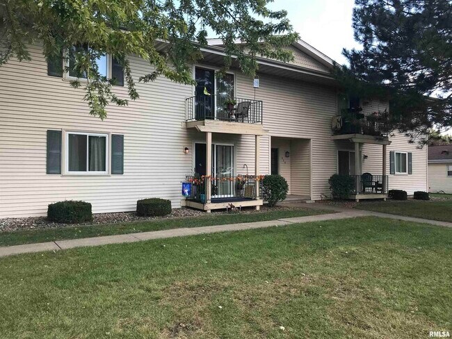
504 S Sweetbriar Dr, Chillicothe, IL 61523


NEARBY LISTINGS FOR SALE OR LEASE
-
-
View all Chillicothe listings for sale on LoopNet.com
Property Detail
504 S Sweetbriar Dr
Peoria
Park Hill
Peoria, IL
PARK HILL ESTATES SW 1/4 & SE 1/4 SEC 29-11-9E LOTS 2 THRU 7 (85-23045/98-00052)
0529378003
Peoria
Commercialnec
Illinois
2024
2-7
2024
1.39 AC
003601
Outlying Peoria County
1,352 SF
DEMOGRAPHICS near 504 S Sweetbriar Dr
1 Mile
3 Mile
5 Mile
2024 Total Population
2,326
7,758
10,427
2029 Population
2,213
7,412
9,964
Pop Growth 2024-2029
(4.86%)
(4.46%)
(4.44%)
Average Age
43
43
43
2024 Total Households
948
3,250
4,288
HH Growth 2024-2029
(5.17%)
(4.65%)
(4.62%)
Median Household Inc
$60,423
$58,143
$63,090
Avg Household Size
2.40
2.30
2.40
2024 Avg HH Vehicles
2.00
2.00
2.00
Median Home Value
$144,969
$140,159
$156,075
Median Year Built
1971
1967
1969
Nearby Places
Map Layers
Map Styles
 Street
 Aerial
- Restaurants
- Banks
- Shops
- Fitness
- Groceries
PUBLIC TRANSPORTATION
AIRPORT
General Downing - Peoria International
DRIVE
WALK
Distance
General Downing - Peoria International
34 min
24.2 mi
Freight Ports
Port Milwaukee
DRIVE
WALK
Distance
Port Milwaukee
244 min
207.8 mi
Nearby Properties
Address
Land Use
TOTAL SIZE
Lot Size
Zoning
Address
Land Use
TOTAL SIZE
Lot Size
Zoning
3,540 SF
6.08 AC
Address
Land Use
TOTAL SIZE
Lot Size
Zoning
Address
Land Use
TOTAL SIZE
Lot Size
Zoning
3.06 AC
Address
Land Use
TOTAL SIZE
Lot Size
Zoning
1.76 AC
Address
Land Use
TOTAL SIZE
Lot Size
Zoning
0.22 AC
Address
Land Use
TOTAL SIZE
Lot Size
Zoning
2,728 SF
1.97 AC
Address
Land Use
TOTAL SIZE
Lot Size
Zoning
Address
Land Use
TOTAL SIZE
Lot Size
Zoning
Address
Land Use
TOTAL SIZE
Lot Size
Zoning
1.41 AC
Address
Land Use
TOTAL SIZE
Lot Size
Zoning
2,406 SF
0.92 AC
Address
Land Use
TOTAL SIZE
Lot Size
Zoning
1.63 AC
Address
Land Use
TOTAL SIZE
Lot Size
Zoning
14.16 AC
Address
Land Use
TOTAL SIZE
Lot Size
Zoning
0.50 AC
Address
Land Use
TOTAL SIZE
Lot Size
Zoning
1.14 AC
Address
Land Use
TOTAL SIZE
Lot Size
Zoning
2,168 SF
0.84 AC
Address
Land Use
TOTAL SIZE
Lot Size
Zoning
Address
Land Use
TOTAL SIZE
Lot Size
Zoning
3.71 AC
Address
Land Use
TOTAL SIZE
Lot Size
Zoning
732 SF
0.66 AC
Address
Land Use
TOTAL SIZE
Lot Size
Zoning
0.80 AC
Address
Land Use
TOTAL SIZE
Lot Size
Zoning
0.62 AC
Address
Land Use
TOTAL SIZE
Lot Size
Zoning
1,344 SF
0.93 AC
Address
Land Use
TOTAL SIZE
Lot Size
Zoning
1,000 SF
14.79 AC
Address
Land Use
TOTAL SIZE
Lot Size
Zoning
Address
Land Use
TOTAL SIZE
Lot Size
Zoning
Address
Land Use
TOTAL SIZE
Lot Size
Zoning
Address
Land Use
TOTAL SIZE
Lot Size
Zoning
0.44 AC
Address
Land Use
TOTAL SIZE
Lot Size
Zoning
0.63 AC
Address
Land Use
TOTAL SIZE
Lot Size
Zoning
0.29 AC
Address
Land Use
TOTAL SIZE
Lot Size
Zoning
1.14 AC
The World's #1 Commercial Real Estate Marketplace
Connect with us
© 2025 CoStar Group
The information above has been obtained from sources believed reliable. While we do not doubt its accuracy we have not verified it and make no guarantee, warranty or representation about it. It is your responsibility to independently confirm its accuracy and completeness. Any projections, opinions, assumptions, or estimates used are for example only and do not represent the current or future performance of the property. The value of this transaction to you depends on tax and other factors which should be evaluated by your tax, financial, and legal advisors. You and your advisors should conduct a careful, independent investigation of the property to determine to your satisfaction the suitability of the property for your needs.