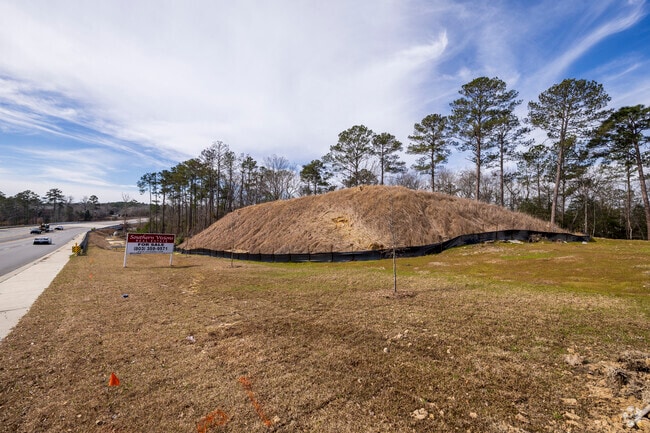
Property Record
5041 E Hard Scrabble Rd, Columbia, SC 29229
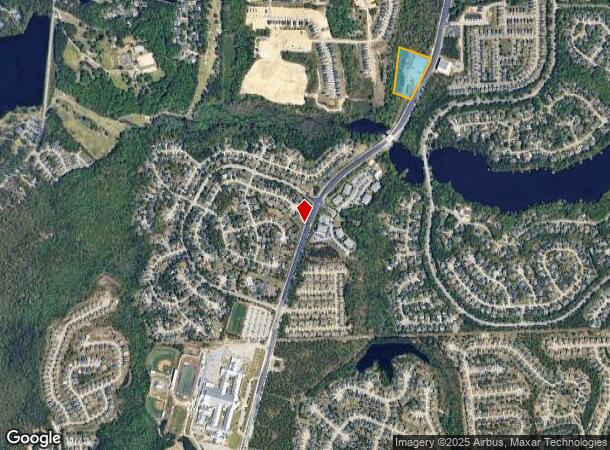
NEARBY LISTINGS FOR SALE OR LEASE
Property Detail
5041 E Hard Scrabble Rd
20400-01-19
588X247.7X61.1X365.2X168.5X447.8 #PR RB1294-3249
Agriculturalland
Richland
X
South Carolina
45079C0142L
4.63 AC
2025
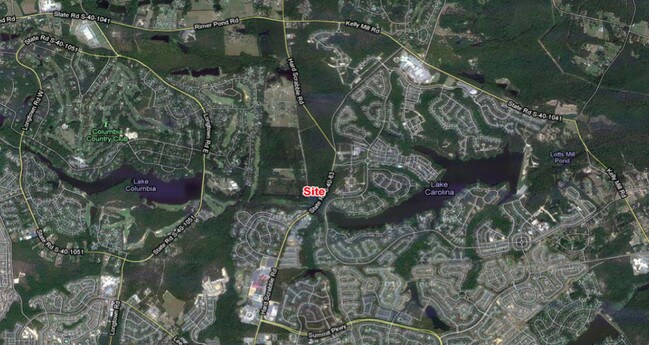
Northeast Columbia
2024
Columbia
010107
Columbia, SC
DEMOGRAPHICS near 5041 E Hard Scrabble Rd
1 Mile
3 Mile
5 Mile
2024 Total Population
7,762
53,654
93,084
2029 Population
7,882
54,377
94,733
Pop Growth 2024-2029
+ 1.55%
+ 1.35%
+ 1.77%
Average Age
37
37
38
2024 Total Households
2,847
19,235
34,719
HH Growth 2024-2029
+ 1.55%
+ 1.33%
+ 1.83%
Median Household Inc
$66,678
$76,947
$73,244
Avg Household Size
2.70
2.70
2.60
2024 Avg HH Vehicles
2.00
2.00
2.00
Median Home Value
$251,806
$215,227
$216,620
Median Year Built
2006
2004
2003
Nearby Places
Map Layers
Map Styles
 Street
 Aerial
- Restaurants
- Banks
- Shops
- Fitness
- Groceries
PUBLIC TRANSPORTATION
AIRPORT
Columbia Metro
DRIVE
WALK
Distance
Columbia Metro
47 min
27.5 mi
Freight Ports
North Charleston Terminal
DRIVE
WALK
Distance
North Charleston Terminal
146 min
124.7 mi
SALE & LEASE HISTORY
LISTING DATE
SALE/LEASE

Sep 24, 2016
For Sale
Feb 06, 2017
For Sale
Apr 27, 2017
For Sale
Apr 27, 2017
For Sale
Nearby Properties
Address
Land Use
TOTAL SIZE
Lot Size
Zoning
Address
Land Use
TOTAL SIZE
Lot Size
Zoning
231,760 SF
23.84 AC
M-1
Address
Land Use
TOTAL SIZE
Lot Size
Zoning
333,002 SF
8.39 AC
GC
Address
Land Use
TOTAL SIZE
Lot Size
Zoning
309,478 SF
8.87 AC
PDD
Address
Land Use
TOTAL SIZE
Lot Size
Zoning
306,612 SF
20.94 AC
GC
Address
Land Use
TOTAL SIZE
Lot Size
Zoning
232,148 SF
14.16 AC
PDD
Address
Land Use
TOTAL SIZE
Lot Size
Zoning
147,916 SF
4.69 AC
OI
Address
Land Use
TOTAL SIZE
Lot Size
Zoning
91,672 SF
12.18 AC
GC
Address
Land Use
TOTAL SIZE
Lot Size
Zoning
275,753 SF
26.21 AC
HI
Address
Land Use
TOTAL SIZE
Lot Size
Zoning
148,809 SF
17.52 AC
M-1
Address
Land Use
TOTAL SIZE
Lot Size
Zoning
143,072 SF
12.61 AC
PDD
Address
Land Use
TOTAL SIZE
Lot Size
Zoning
75,893 SF
10 AC
PDD
Address
Land Use
TOTAL SIZE
Lot Size
Zoning
68,091 SF
4.35 AC
OI
Address
Land Use
TOTAL SIZE
Lot Size
Zoning
125,894 SF
7.77 AC
PDD
Address
Land Use
TOTAL SIZE
Lot Size
Zoning
73,901 SF
8.83 AC
PUD
Address
Land Use
TOTAL SIZE
Lot Size
Zoning
117,832 SF
10.82 AC
PDD
Address
Land Use
TOTAL SIZE
Lot Size
Zoning
42,938 SF
7.30 AC
HI
Address
Land Use
TOTAL SIZE
Lot Size
Zoning
103,719 SF
4.05 AC
RM-HD
Address
Land Use
TOTAL SIZE
Lot Size
Zoning
74,014 SF
22.02 AC
HI
Address
Land Use
TOTAL SIZE
Lot Size
Zoning
2,574 SF
5.83 AC
GC
Address
Land Use
TOTAL SIZE
Lot Size
Zoning
44.55 AC
PDD
Address
Land Use
TOTAL SIZE
Lot Size
Zoning
75,250 SF
4.12 AC
PDD
Address
Land Use
TOTAL SIZE
Lot Size
Zoning
14,736 SF
1.45 AC
GC
Address
Land Use
TOTAL SIZE
Lot Size
Zoning
69,202 SF
11.98 AC
PDD
Address
Land Use
TOTAL SIZE
Lot Size
Zoning
2,000 SF
6.21 AC
HI
Address
Land Use
TOTAL SIZE
Lot Size
Zoning
43,822 SF
4.35 AC
GC
Address
Land Use
TOTAL SIZE
Lot Size
Zoning
36.46 AC
PDD
Address
Land Use
TOTAL SIZE
Lot Size
Zoning
15,009 SF
1.69 AC
M-1
Address
Land Use
TOTAL SIZE
Lot Size
Zoning
43,600 SF
5.61 AC
HI
Address
Land Use
TOTAL SIZE
Lot Size
Zoning
54,254 SF
6.83 AC
PDD
Address
Land Use
TOTAL SIZE
Lot Size
Zoning
17,805 SF
4.65 AC
RU
The World's #1 Commercial Real Estate Marketplace
Connect with us
© 2026 CoStar Group
The information above has been obtained from sources believed reliable. While we do not doubt its accuracy we have not verified it and make no guarantee, warranty or representation about it. It is your responsibility to independently confirm its accuracy and completeness. Any projections, opinions, assumptions, or estimates used are for example only and do not represent the current or future performance of the property. The value of this transaction to you depends on tax and other factors which should be evaluated by your tax, financial, and legal advisors. You and your advisors should conduct a careful, independent investigation of the property to determine to your satisfaction the suitability of the property for your needs.