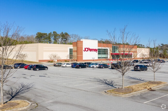
Property Record
5043 Jimmy Lee Smith Pkwy, Hiram, GA 30141
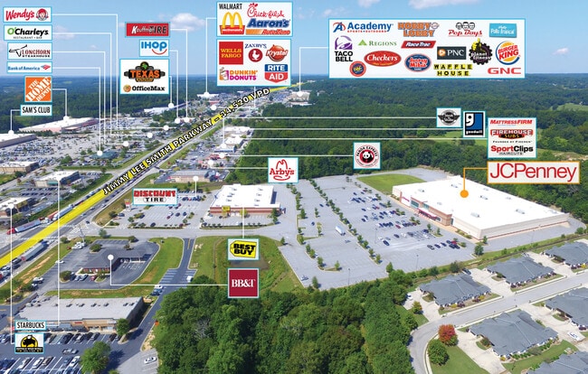

NEARBY LISTINGS FOR SALE OR LEASE
Property Detail
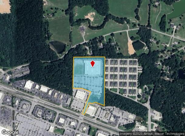
5043 Jimmy Lee Smith Pkwy
Atlanta-Sandy Springs-Roswell, GA
REAL PROPERTY
176.2.1.016.0000
Paulding
Storebuilding
Georgia
2024
612
2024
13.41 AC
120206
Paulding Cnty/Dallas
103,185 SF
Atlanta
DEMOGRAPHICS near 5043 Jimmy Lee Smith Pkwy
1 Mile
3 Mile
5 Mile
2024 Total Population
2,762
34,705
93,125
2029 Population
3,163
38,450
101,588
Pop Growth 2024-2029
+ 14.52%
+ 10.79%
+ 9.09%
Average Age
40
39
39
2024 Total Households
1,137
12,412
32,742
HH Growth 2024-2029
+ 14.42%
+ 11.09%
+ 9.33%
Median Household Inc
$75,154
$93,970
$95,441
Avg Household Size
2.40
2.80
2.80
2024 Avg HH Vehicles
2.00
2.00
2.00
Median Home Value
$194,359
$267,858
$276,677
Median Year Built
2001
1997
1996
Nearby Places
Map Layers
Map Styles
 Street
 Aerial
- Restaurants
- Banks
- Shops
- Fitness
- Groceries
PUBLIC TRANSPORTATION
AIRPORT
Hartsfield - Jackson Atlanta International
DRIVE
WALK
Distance
Hartsfield - Jackson Atlanta International
52 min
34.2 mi
SALE & LEASE HISTORY
LISTING DATE
SALE/LEASE

Sep 28, 2017
For Sale
Oct 13, 2017
For Sale
Oct 12, 2017
For Sale
Jun 20, 2022
For Sale
Nearby Properties
Address
Land Use
TOTAL SIZE
Lot Size
Zoning
Address
Land Use
TOTAL SIZE
Lot Size
Zoning
62,628 SF
32.23 AC
B2
Address
Land Use
TOTAL SIZE
Lot Size
Zoning
69.17 AC
Address
Land Use
TOTAL SIZE
Lot Size
Zoning
126,638 SF
20.26 AC
R4
Address
Land Use
TOTAL SIZE
Lot Size
Zoning
93.77 AC
Address
Land Use
TOTAL SIZE
Lot Size
Zoning
187,435 SF
31.39 AC
R55
Address
Land Use
TOTAL SIZE
Lot Size
Zoning
25.10 AC
Address
Land Use
TOTAL SIZE
Lot Size
Zoning
37.28 AC
Address
Land Use
TOTAL SIZE
Lot Size
Zoning
15.02 AC
Address
Land Use
TOTAL SIZE
Lot Size
Zoning
238,291 SF
22.51 AC
B2
Address
Land Use
TOTAL SIZE
Lot Size
Zoning
19,718 SF
0.52 AC
B1
Address
Land Use
TOTAL SIZE
Lot Size
Zoning
141,658 SF
17.36 AC
PSC
Address
Land Use
TOTAL SIZE
Lot Size
Zoning
35,442 SF
0.66 AC
B1
Address
Land Use
TOTAL SIZE
Lot Size
Zoning
Address
Land Use
TOTAL SIZE
Lot Size
Zoning
25.34 AC
Address
Land Use
TOTAL SIZE
Lot Size
Zoning
198,684 SF
21.35 AC
B2
Address
Land Use
TOTAL SIZE
Lot Size
Zoning
171,184 SF
14.63 AC
PSC
Address
Land Use
TOTAL SIZE
Lot Size
Zoning
151,906 SF
21.07 AC
B2
Address
Land Use
TOTAL SIZE
Lot Size
Zoning
71,122 SF
30.70 AC
C2
Address
Land Use
TOTAL SIZE
Lot Size
Zoning
149,128 SF
108.92 AC
I1
Address
Land Use
TOTAL SIZE
Lot Size
Zoning
133,006 SF
15.53 AC
PSC
Address
Land Use
TOTAL SIZE
Lot Size
Zoning
67,341 SF
9.07 AC
GC
Address
Land Use
TOTAL SIZE
Lot Size
Zoning
44,972 SF
7.81 AC
B2
Address
Land Use
TOTAL SIZE
Lot Size
Zoning
71,301 SF
3.88 AC
B1
Address
Land Use
TOTAL SIZE
Lot Size
Zoning
136,556 SF
7.24 AC
B2
Address
Land Use
TOTAL SIZE
Lot Size
Zoning
185,183 SF
6.99 AC
OI
Address
Land Use
TOTAL SIZE
Lot Size
Zoning
74,036 SF
23.20 AC
B2
Address
Land Use
TOTAL SIZE
Lot Size
Zoning
367,298 SF
15.38 AC
LI
Address
Land Use
TOTAL SIZE
Lot Size
Zoning
7.69 AC
Address
Land Use
TOTAL SIZE
Lot Size
Zoning
86,556 SF
8.10 AC
PSC
The World's #1 Commercial Real Estate Marketplace
Connect with us
© 2025 CoStar Group
The information above has been obtained from sources believed reliable. While we do not doubt its accuracy we have not verified it and make no guarantee, warranty or representation about it. It is your responsibility to independently confirm its accuracy and completeness. Any projections, opinions, assumptions, or estimates used are for example only and do not represent the current or future performance of the property. The value of this transaction to you depends on tax and other factors which should be evaluated by your tax, financial, and legal advisors. You and your advisors should conduct a careful, independent investigation of the property to determine to your satisfaction the suitability of the property for your needs.