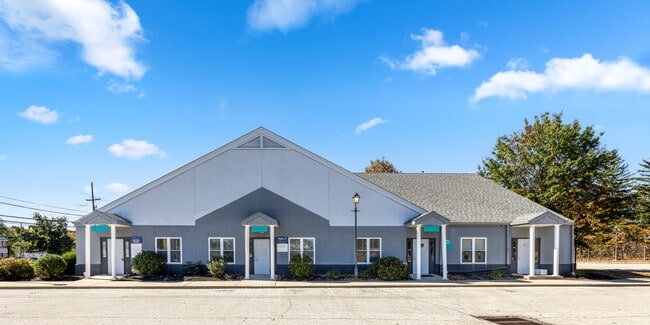
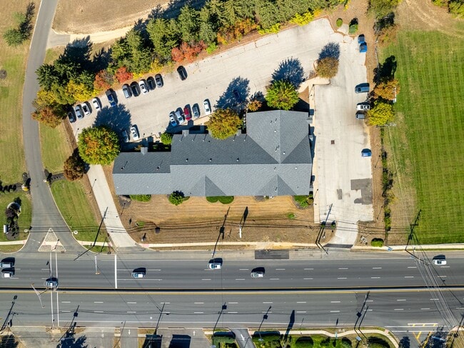
Property Record
5045 Route 130, Delran, NJ 08075

Property Detail
5045 Route 130
10-00046-0000-00018
Burlington
Vacantlandnec
New Jersey
B and X Area of moderate flood hazard, usually the area between the limits of the 100-year and 500-year floods.
18
2024
1.95 AC
2025
North Burlington County
700603
Philadelphia
15,585 SF
Philadelphia-Camden-Wilmington, PA-NJ-DE-MD
NEARBY LISTINGS FOR SALE OR LEASE
DEMOGRAPHICS near 5045 Route 130
1 mile
3 mile
5 mile
2025 Total Population
10,959
61,115
236,702
2030 Population
11,300
62,820
238,964
Pop Growth 2025-2030
+ 3.11%
+ 2.79%
+ 0.96%
Average Age
40
42
41
2025 Total Households
4,208
23,438
90,924
HH Growth 2025-2030
+ 3.23%
+ 2.62%
+ 0.91%
Median Household Inc
$97,046
$98,845
$90,906
Avg Household Size
2.50
2.60
2.50
2025 Avg HH Vehicles
2.00
2.00
2.00
Median Home Value
$349,802
$334,730
$294,856
Median Year Built
1969
1970
1964
Nearby Places
Map Layers
Map Styles
 Street
 Aerial
Transit
 Traffic
 Biking
Places
Listings with unknown addresses are not visible on the map
- Restaurants
- Banks
- Shops
- Fitness
- Groceries
PUBLIC TRANSPORTATION
AIRPORT
Philadelphia International
Drive
Walk
Distance
Philadelphia International
37 min
22.4 mi
Trenton Mercer
Drive
Walk
Distance
Trenton Mercer
41 min
25.0 mi
Freight Ports
Port of Philadelphia
Drive
Walk
Distance
Port of Philadelphia
17 min
10.0 mi
SALE & LEASE HISTORY
LISTING DATE
SALE/LEASE

Sep 18, 2024
For Lease
Oct 10, 2024
For Sale
Jan 17, 2019
For Lease
Jan 08, 2020
For Lease
Nearby Properties
Address
Land Use
TOTAL SIZE
Lot Size
Zoning
Address
Land Use
TOTAL SIZE
Lot Size
Zoning
2,183 SF
61.10 AC
Address
Land Use
TOTAL SIZE
Lot Size
Zoning
95.79 AC
Address
Land Use
TOTAL SIZE
Lot Size
Zoning
16.69 AC
Address
Land Use
TOTAL SIZE
Lot Size
Zoning
5.70 AC
R2
Address
Land Use
TOTAL SIZE
Lot Size
Zoning
15.02 AC
Address
Land Use
TOTAL SIZE
Lot Size
Zoning
22.49 AC
Address
Land Use
TOTAL SIZE
Lot Size
Zoning
27.33 AC
Address
Land Use
TOTAL SIZE
Lot Size
Zoning
82.32 AC
Address
Land Use
TOTAL SIZE
Lot Size
Zoning
19 AC
Address
Land Use
TOTAL SIZE
Lot Size
Zoning
79.78 AC
Address
Land Use
TOTAL SIZE
Lot Size
Zoning
Address
Land Use
TOTAL SIZE
Lot Size
Zoning
24.56 AC
Address
Land Use
TOTAL SIZE
Lot Size
Zoning
205,472 SF
8.40 AC
RM2
Address
Land Use
TOTAL SIZE
Lot Size
Zoning
20.30 AC
Address
Land Use
TOTAL SIZE
Lot Size
Zoning
19.97 AC
Address
Land Use
TOTAL SIZE
Lot Size
Zoning
39.58 AC
Address
Land Use
TOTAL SIZE
Lot Size
Zoning
208,527 SF
7.80 AC
RM2
Address
Land Use
TOTAL SIZE
Lot Size
Zoning
152,835 SF
4.46 AC
RM2
Address
Land Use
TOTAL SIZE
Lot Size
Zoning
3.44 AC
I-2
Address
Land Use
TOTAL SIZE
Lot Size
Zoning
28.64 AC
Address
Land Use
TOTAL SIZE
Lot Size
Zoning
130,000 SF
12.50 AC
RM2
Address
Land Use
TOTAL SIZE
Lot Size
Zoning
7.97 AC
Address
Land Use
TOTAL SIZE
Lot Size
Zoning
28.32 AC
CD
Address
Land Use
TOTAL SIZE
Lot Size
Zoning
1,808 SF
16.06 AC
I-2
Address
Land Use
TOTAL SIZE
Lot Size
Zoning
59.32 AC
Address
Land Use
TOTAL SIZE
Lot Size
Zoning
53,009 SF
5.44 AC
RM2
Address
Land Use
TOTAL SIZE
Lot Size
Zoning
25.70 AC
Address
Land Use
TOTAL SIZE
Lot Size
Zoning
Address
Land Use
TOTAL SIZE
Lot Size
Zoning
13.28 AC
Address
Land Use
TOTAL SIZE
Lot Size
Zoning
1,384 SF
15.47 AC
The World's #1 Commercial Real Estate Marketplace
Connect with us
© 2026 CoStar Group
The information above has been obtained from sources believed reliable. While we do not doubt its accuracy we have not verified it and make no guarantee, warranty or representation about it. It is your responsibility to independently confirm its accuracy and completeness. Any projections, opinions, assumptions, or estimates used are for example only and do not represent the current or future performance of the property. The value of this transaction to you depends on tax and other factors which should be evaluated by your tax, financial, and legal advisors. You and your advisors should conduct a careful, independent investigation of the property to determine to your satisfaction the suitability of the property for your needs.