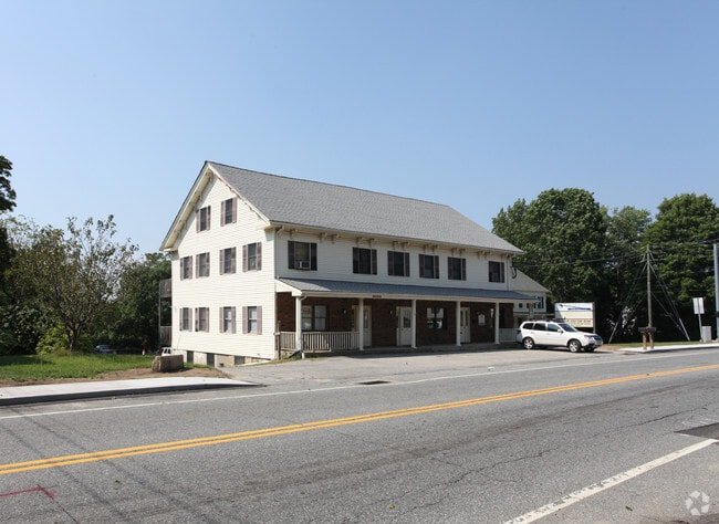
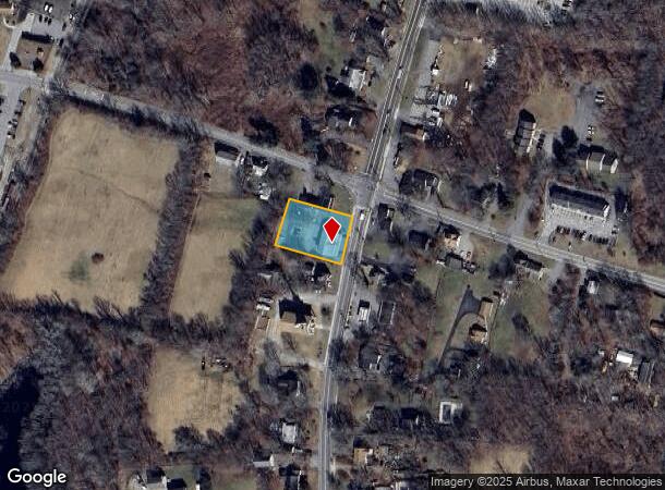
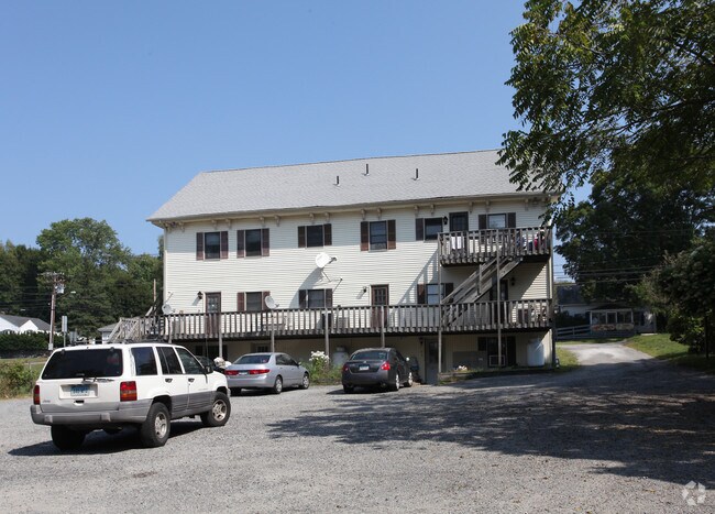
Property Record
505 Norwich Rd, Plainfield, CT 06374
NEARBY LISTINGS FOR SALE OR LEASE
-
-
View all Plainfield listings for lease on LoopNet.com
Property Detail
505 Norwich Rd
PLAI-000001P-000039-000004
Windham
Commercialofficeresidentialmixeduse
Connecticut
X
4
09015C0366F
0.58 AC
2024
Windham County
2025
Hartford
907300
Willimantic, CT
5,439 SF
DEMOGRAPHICS near 505 Norwich Rd
1 Mile
3 Mile
5 Mile
2024 Total Population
3,054
10,456
19,805
2029 Population
3,052
10,403
19,641
Pop Growth 2024-2029
(0.07%)
(0.51%)
(0.83%)
Average Age
43
41
41
2024 Total Households
1,228
4,145
7,758
HH Growth 2024-2029
(0.16%)
(0.53%)
(0.81%)
Median Household Inc
$60,908
$65,926
$74,550
Avg Household Size
2.40
2.40
2.50
2024 Avg HH Vehicles
2.00
2.00
2.00
Median Home Value
$179,287
$213,130
$239,612
Median Year Built
1967
1968
1971
Nearby Places
Map Layers
Map Styles
 Street
 Aerial
- Restaurants
- Banks
- Shops
- Fitness
- Groceries
PUBLIC TRANSPORTATION
AIRPORT
Rhode Island Tf Green International
DRIVE
WALK
Distance
Rhode Island Tf Green International
51 min
37.5 mi
Freight Ports
Port of Davisville, RI
DRIVE
WALK
Distance
Port of Davisville, RI
62 min
35.3 mi
SALE & LEASE HISTORY
LISTING DATE
SALE/LEASE

Jul 17, 2025
For Lease
Jul 13, 2020
For Lease
Nearby Properties
Address
Land Use
TOTAL SIZE
Lot Size
Zoning
Address
Land Use
TOTAL SIZE
Lot Size
Zoning
202.19 AC
IND
Address
Land Use
TOTAL SIZE
Lot Size
Zoning
202,044 SF
52.20 AC
I
Address
Land Use
TOTAL SIZE
Lot Size
Zoning
37.12 AC
RA60
Address
Land Use
TOTAL SIZE
Lot Size
Zoning
54,304 SF
28.41 AC
IND-2
Address
Land Use
TOTAL SIZE
Lot Size
Zoning
13,444 SF
10.94 AC
RA30
Address
Land Use
TOTAL SIZE
Lot Size
Zoning
27,400 SF
4.34 AC
C2
Address
Land Use
TOTAL SIZE
Lot Size
Zoning
55,128 SF
5 AC
RA19
Address
Land Use
TOTAL SIZE
Lot Size
Zoning
15.20 AC
C
Address
Land Use
TOTAL SIZE
Lot Size
Zoning
10.29 AC
RA19
Address
Land Use
TOTAL SIZE
Lot Size
Zoning
2,836 SF
139.54 AC
I
Address
Land Use
TOTAL SIZE
Lot Size
Zoning
35,165 SF
6.63 AC
RA30
Address
Land Use
TOTAL SIZE
Lot Size
Zoning
800 SF
15.50 AC
Address
Land Use
TOTAL SIZE
Lot Size
Zoning
11.29 AC
C
Address
Land Use
TOTAL SIZE
Lot Size
Zoning
6.26 AC
C
Address
Land Use
TOTAL SIZE
Lot Size
Zoning
Address
Land Use
TOTAL SIZE
Lot Size
Zoning
34,830 SF
2.52 AC
C2
Address
Land Use
TOTAL SIZE
Lot Size
Zoning
80,180 SF
9.66 AC
IND-1
Address
Land Use
TOTAL SIZE
Lot Size
Zoning
10,937 SF
2.54 AC
C2
Address
Land Use
TOTAL SIZE
Lot Size
Zoning
11.40 AC
CI
Address
Land Use
TOTAL SIZE
Lot Size
Zoning
28,494 SF
6.67 AC
C2
Address
Land Use
TOTAL SIZE
Lot Size
Zoning
8.30 AC
RA30
Address
Land Use
TOTAL SIZE
Lot Size
Zoning
13,812 SF
1.70 AC
RA19
Address
Land Use
TOTAL SIZE
Lot Size
Zoning
26,796 SF
2.89 AC
I
Address
Land Use
TOTAL SIZE
Lot Size
Zoning
233,322 SF
13.60 AC
I
Address
Land Use
TOTAL SIZE
Lot Size
Zoning
18,600 SF
2.50 AC
RA19
Address
Land Use
TOTAL SIZE
Lot Size
Zoning
12,692 SF
2.46 AC
C2
Address
Land Use
TOTAL SIZE
Lot Size
Zoning
334 AC
RA60
Address
Land Use
TOTAL SIZE
Lot Size
Zoning
52.63 AC
IND-1
Address
Land Use
TOTAL SIZE
Lot Size
Zoning
10,000 SF
6.25 AC
IND
Address
Land Use
TOTAL SIZE
Lot Size
Zoning
6,889 SF
1.04 AC
C
The World's #1 Commercial Real Estate Marketplace
Connect with us
© 2026 CoStar Group
The information above has been obtained from sources believed reliable. While we do not doubt its accuracy we have not verified it and make no guarantee, warranty or representation about it. It is your responsibility to independently confirm its accuracy and completeness. Any projections, opinions, assumptions, or estimates used are for example only and do not represent the current or future performance of the property. The value of this transaction to you depends on tax and other factors which should be evaluated by your tax, financial, and legal advisors. You and your advisors should conduct a careful, independent investigation of the property to determine to your satisfaction the suitability of the property for your needs.