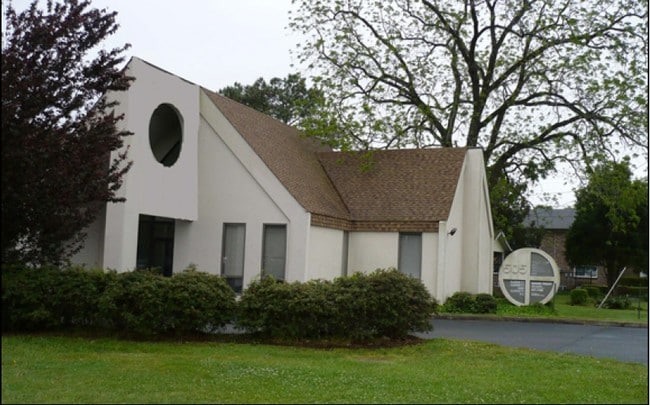
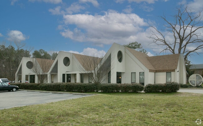
Property Record
505 Cedar Rd, Chesapeake, VA 23322
Current Lease Availabilities
Property Detail
505 Cedar Rd
0470000000783
PTS PAR A MIKE RUFFIN PROP & 20FT LANE 0.978AC
Officebuilding
CHESAPEAKE
O-I: OFFIC
Virginia
B and X Area of moderate flood hazard, usually the area between the limits of the 100-year and 500-year floods.
1.22 AC
2024
Southern Chesapeake
2025
Hampton Roads
021010
Virginia Beach-Chesapeake-Norfolk, VA-NC
5,220 SF
NEARBY LISTINGS FOR SALE OR LEASE
DEMOGRAPHICS near 505 Cedar Rd
1 mile
3 mile
5 mile
2024 Total Population
10,386
59,597
126,998
2029 Population
10,504
60,276
128,809
Pop Growth 2024-2029
+ 1.14%
+ 1.14%
+ 1.43%
Average Age
39
40
40
2024 Total Households
3,516
22,135
46,479
HH Growth 2024-2029
+ 1.25%
+ 1.20%
+ 1.47%
Median Household Inc
$113,215
$112,714
$110,214
Avg Household Size
2.60
2.60
2.70
2024 Avg HH Vehicles
2.00
2.00
2.00
Median Home Value
$420,506
$424,823
$429,409
Median Year Built
1988
1992
1993
Nearby Places
Map Layers
Map Styles
 Street
 Aerial
Transit
 Traffic
 Biking
Places
Listings with unknown addresses are not visible on the map
- Restaurants
- Banks
- Shops
- Fitness
- Groceries
PUBLIC TRANSPORTATION
AIRPORT
Norfolk International
Drive
Walk
Distance
Norfolk International
28 min
17.0 mi
Freight Ports
Virginia Port Authority - Portsmouth
Drive
Walk
Distance
Virginia Port Authority - Portsmouth
27 min
15.7 mi
Nearby Properties
Address
Land Use
TOTAL SIZE
Lot Size
Zoning
Address
Land Use
TOTAL SIZE
Lot Size
Zoning
470,098 SF
14.10 AC
O-I: OFFIC
Address
Land Use
TOTAL SIZE
Lot Size
Zoning
6,820 SF
89.90 AC
R15S: RESI
Address
Land Use
TOTAL SIZE
Lot Size
Zoning
141,461 SF
169.22 AC
C1: CONSER
Address
Land Use
TOTAL SIZE
Lot Size
Zoning
26.78 AC
RMF1: MULT
Address
Land Use
TOTAL SIZE
Lot Size
Zoning
299,727 SF
170.79 AC
C1: CONSER
Address
Land Use
TOTAL SIZE
Lot Size
Zoning
154,540 SF
1.68 AC
O-I: OFFIC
Address
Land Use
TOTAL SIZE
Lot Size
Zoning
286,936 SF
15 AC
RMF1: MULT
Address
Land Use
TOTAL SIZE
Lot Size
Zoning
140,369 SF
10.35 AC
PUD: PLANN
Address
Land Use
TOTAL SIZE
Lot Size
Zoning
264,336 SF
73.49 AC
A1: AGRICU
Address
Land Use
TOTAL SIZE
Lot Size
Zoning
277,846 SF
12.50 AC
RMF1: MULT
Address
Land Use
TOTAL SIZE
Lot Size
Zoning
75,936 SF
11.13 AC
MULTI: MUL
Address
Land Use
TOTAL SIZE
Lot Size
Zoning
188,683 SF
13.14 AC
O-I: OFFIC
Address
Land Use
TOTAL SIZE
Lot Size
Zoning
256,041 SF
12.32 AC
RMF1: MULT
Address
Land Use
TOTAL SIZE
Lot Size
Zoning
63,050 SF
27.71 AC
O-I: OFFIC
Address
Land Use
TOTAL SIZE
Lot Size
Zoning
196,905 SF
46.84 AC
R15S: RESI
Address
Land Use
TOTAL SIZE
Lot Size
Zoning
67,508 SF
16.63 AC
O-I: OFFIC
Address
Land Use
TOTAL SIZE
Lot Size
Zoning
152,650 SF
5.53 AC
O-I: OFFIC
Address
Land Use
TOTAL SIZE
Lot Size
Zoning
175,028 SF
12.41 AC
RMF1: MULT
Address
Land Use
TOTAL SIZE
Lot Size
Zoning
99,662 SF
15.68 AC
B2: GENERA
Address
Land Use
TOTAL SIZE
Lot Size
Zoning
1,188 SF
73.88 AC
A1: AGRICU
Address
Land Use
TOTAL SIZE
Lot Size
Zoning
190,194 SF
12.40 AC
RMF1: MULT
Address
Land Use
TOTAL SIZE
Lot Size
Zoning
50,416 SF
13.30 AC
RMF1: MULT
Address
Land Use
TOTAL SIZE
Lot Size
Zoning
27,696 SF
15.80 AC
B1: NEIGHB
Address
Land Use
TOTAL SIZE
Lot Size
Zoning
201,130 SF
5.44 AC
RMF1: MULT
Address
Land Use
TOTAL SIZE
Lot Size
Zoning
110,988 SF
6.33 AC
O-I: OFFIC
Address
Land Use
TOTAL SIZE
Lot Size
Zoning
91,968 SF
6.33 AC
O-I: OFFIC
Address
Land Use
TOTAL SIZE
Lot Size
Zoning
129,138 SF
8.86 AC
RMF1: MULT
Address
Land Use
TOTAL SIZE
Lot Size
Zoning
50,978 SF
10.43 AC
B2: GENERA
Address
Land Use
TOTAL SIZE
Lot Size
Zoning
38,354 SF
2.23 AC
PUD: PLANN
Address
Land Use
TOTAL SIZE
Lot Size
Zoning
103,693 SF
5.83 AC
O-I: OFFIC
The World's #1 Commercial Real Estate Marketplace
Connect with us
© 2026 CoStar Group
The information above has been obtained from sources believed reliable. While we do not doubt its accuracy we have not verified it and make no guarantee, warranty or representation about it. It is your responsibility to independently confirm its accuracy and completeness. Any projections, opinions, assumptions, or estimates used are for example only and do not represent the current or future performance of the property. The value of this transaction to you depends on tax and other factors which should be evaluated by your tax, financial, and legal advisors. You and your advisors should conduct a careful, independent investigation of the property to determine to your satisfaction the suitability of the property for your needs.